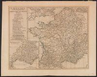
Anville, Jean Baptiste Bourguignon d', 1697-1782 Chapman, Thomas, fl. 1790-1803 Neele, Samuel John, 1758-1824, engraver Pauw, Cornelius, 1739-1799. Philosophical dissertations on the Egyptians and Chinese
Published / Created:
Jany. 1st, 1795.
Call Number:
1977 Folio 177
Image Count:
2
Resource Type:
Maps, Atlases & Globes
Description:
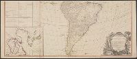
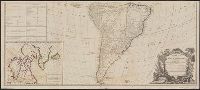
"Neele, sculpt.", Ms. note at head of title: De Pauw. Sheet measures 50.7 x 63.8 cm. No. 15 of 34 maps bound together., Prime meridians: Ferro., Relief shown pictorially., and Watermark.
Both sheets backed with paper., Includes text and historical notes., Inset: Chart of Falkland Islands named by the French Malouine Islands and discovered by Hawkins in the year 1593., Outline color., Prime meridian: Ferro., Relief sh, and Watermarks on both sheets.
Publisher:
Sayer and Bennett,
Subject (Geographic):
Falkland Islands--Maps--Early works to 1800 and South America--Maps--Early works to 1800
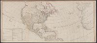
"Publish'd by Laurie & Whittle, No. 53 Fleet Street, as the Act directs, 12th May 1794.", Appears in Thomas Kitchin's General atlas, describing the whole universe., Includes table, "The Continent and Islands of America are Divided and Possessed as follows viz.", Inset: The supplement to North America containing the countries adjoining to Baffins & Hudson bays., Joined into two sheets measuring 53.8 x 121.6 cm. and 53.8 x 121.2 cm. Stamped number on top sheet: 60. Stamped number on top sheet: 61. Cross Collection no. 139., Prime meridian: Ferro., Re-issue of John Gibson's map of [1763], 1772, 1777, 1783, and 1786., Relief shown pictorially., Shows the Western Hemisphere with some political borders, tabular information indicates national possessions; cities and rivers., and Title from ornamental cartouche.
Publisher:
Laurie & Whittle,
Subject (Geographic):
America--Maps--Early works to 1800 and West Indies--Maps--Early works to 1800
Subject (Name):
Gibson, J. (John), Kitchin, Thomas, d. 1784. General atlas describing the whole universe, Pownall, Thomas, 1722-1805, and Robert Laurie and James Whittle
"Publish'd by Laurie & Whittle, No. 53 Fleet Street, as the Act directs, 12th May 1794.", Appears in Thomas Kitchin's General atlas, describing the whole universe., Copy 2: Joined into two sheets measuring 53.7 x 125.6 cm. and 53.7 x 125.6 cm. Stamped number on sheets: 34. Franklin Collection no. 131 1794 11-12., Includes table, "The Continent and Islands of America are Divided and Possessed as follows viz.", Inset: The supplement to North America containing the countries adjoining to Baffins & Hudson bays., Prime meridian: Ferro., Re-issue of John Gibson's map of [1763], 1772, 1777, 1783, and 1786., Relief shown pictorially., Shows the Western Hemisphere with some political borders, tabular information indicates national possessions; cities and rivers., and Title from ornamental cartouche.
Publisher:
Laurie & Whittle,
Subject (Geographic):
America--Maps--Early works to 1800 and West Indies--Maps--Early works to 1800
Subject (Name):
Gibson, J. (John), Kitchin, Thomas, d. 1784. General atlas describing the whole universe, Pownall, Thomas, 1722-1805, and Robert Laurie and James Whittle
"Publish'd by Laurie & Whittle, No. 53 Fleet Street, as the Act directs, 12th May 1794.", Appears in Thomas Kitchin's General atlas, describing the whole universe., Copy 3: Joined into two sheets measuring 54.7 x 123.5 cm. and 54.6 x 123.4 cm. Stamped number on top sheet: 32. Stamped number on top sheet: 33. Franklin Collection no. 131 1794 13-14., Includes table, "The Continent and Islands of America are Divided and Possessed as follows viz.", Inset: The supplement to North America containing the countries adjoining to Baffins & Hudson bays., Prime meridian: Ferro., Re-issue of John Gibson's map of [1763], 1772, 1777, 1783, and 1786., Relief shown pictorially., Shows the Western Hemisphere with some political borders, tabular information indicates national possessions; cities and rivers., and Title from ornamental cartouche.
Publisher:
Laurie & Whittle,
Subject (Geographic):
America--Maps--Early works to 1800 and West Indies--Maps--Early works to 1800
Subject (Name):
Gibson, J. (John), Kitchin, Thomas, d. 1784. General atlas describing the whole universe, Pownall, Thomas, 1722-1805, and Robert Laurie and James Whittle
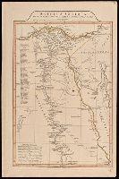
"9"--Manuscript note in upper right corner of sheet. Accompanied by: Title page: A complete body of ancient geography by Mons. D'Anville ... London : James Whittle and Richard Holmes Laurie, 1818 (1 sheet)., Includes index., Includes six bar scales., Prime meridian: Ferro., Relief shown by hachures., and Watermark.
Publisher:
Laurie & Whittle,
Subject (Geographic):
Egypt--Administrative and political divisions--Maps. and Egypt--Maps.