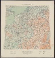
Great Britain. War Office. General Staff. Geographical Section
Published / Created:
1915
Call Number:
11hc 1915E
Image Count:
1
Resource Type:
Maps, Atlases & Globes
Alternative Title:
Geographical Section General Staff ; 3024 and GSGS (Series) ; 3024.
Description:
Ms. notes outside bottom right margin: "Based on Paris M31, Frankfurt M32, Lyons L31 & Milan L32, of Europe 1:1,000,000.", Relief shown as contours and gradient tints., and Shows: international boundaries, relative importance of towns, railways (2 categories),
Publisher:
G.S.G.S.,
Subject (Geographic):
Belgium--Maps and France--Maps
Subject (Topic):
World War, 1914-1918--Belgium--Maps and World War, 1914-1918--France--Maps
Coordinates not present on item and are approximated., Insets: Plan of Salesbury -- Image of Stone Henge -- 14 coats of arms of the "Earles of Wilshyre & Salesburye." Images of "The armes of the Earles of Wilshyre & Salesburye ..." appear in the lower left of the map., On verso: English text with running-title "Book I. Wilt-Shire. Chap. 14", Signature "R", p. 25 and 26., Originally issued ca. 1610 and appeared in: Theatre of the Empire of Great Britaine. London, Sudbury & Humble, 1614 (i.e. 1616)., and Relief shown pictorially.
Publisher:
Performed by Iohn Speed and are to be sold in Popes head alley against the Exchange by Iohn Sudbury and G. Humble, cum privilegio,
Subject (Geographic):
Salisbury (England)--Maps--Early works to 1800, Stonehenge (England)--Maps--Early works to 1800, and Wiltshire (England)--Maps--Early works to 1800
Subject (Name):
Humble, George, -1640, Speed, John, 1552?-1629. Theatre of the Empire of Great Britaine, and Sudbury, John
From the Atlantic Neptune, Vol.3, ,,, the coast and harbours of New England ... From the surveys ... by Samuel Holland, Esq. Part II. Plate "9". and Stipple engraved sailing chart, land col. pale brown by hand, modified for individual holdings, cities red. Hi
Des Barres, Joseph F. W. (Joseph Frederick Wallet), 1722-1824
Published / Created:
Augt. 1st, 1781.
Call Number:
734 S46 1781
Container / Volume:
BRBL_00380
Image Count:
1
Resource Type:
Maps, Atlases & Globes
Description:
Appears in the author's Atlantic neptune., Has watermark., Oriented with north to the right., Relief shown by hachures and shading. Depths shown by soundings., and Title supplied by cataloger.
Publisher:
J.F.W. Des Barres,
Subject (Geographic):
Sept-Iles (Québec)--Maps--Early works to 1800 and Seven Islands Bay (Québec)--Maps--Early works to 1800
Subject (Name):
Des Barres, Joseph F. W. (Joseph Frederick Wallet), 1722-1824. Atlantic neptune
Subject (Topic):
Harbors--Québec--Sept-Iles--Maps--Early works to 1800
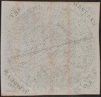
The earth's eastern planisphere., The earth's western planisphere., The eastern planisphere of the heavens., and The western planisphere of the heavens.
Description:
2 astronomical charts, 2 hemispherical maps, 1 untitled slider sheet. and Imperfect: Sheet 5 trimmed, with some loss of text.
Publisher:
Published ... by S. Dunn & W. Owen,
Subject (Geographic):
Eastern Hemisphere--Maps--Early works to 1800 and Western Hemisphere--Maps--Early works to 1800
Subject (Name):
Dunn, Samuel, d. 1794, publisher
Subject (Topic):
Constellations--Charts, diagrams, etc.--Early works to 1800