John Huighen van Linschoten, his Discours of Voyages into ye Easte & West Indies
Image Count:
1
Description:
[Scale ca. 1:13,500,000]., Bound in following p. 32., and Map has several small brown marks on the left portion that can also be seen on the verso.
Subject (Geographic):
Borneo --Maps --Early works to 1800, China --Maps --1368-1644, Japan --Maps --Early works to 1800, Java (Indonesia) --Maps --Early works to 1800, and Sumatra (Indonesia) --Maps
Subject (Name):
Wolfe, John, d. 1601, printer
Subject (Topic):
Voyages and travels --Early works to 1800
Collection Created:
[London] : Printed at London by [John Windet for] Iohn Wolfe, printer to ye Honorable Cittie of London, [1598]
Insets: Vista de ma Mina de Corbou descubierta per F. Ferrer en Choutáles -- Plan y vista de las Minas Luigalpa en Choudales -- Plan de hatogrande en Choudales., Prime meridians: Washington - Greenwich., and Relief shown by hachures; depths shown by isolines.
In bottom margin: Andrew B. Graham, photo-litho, Washington, D.C., In English and Spanish., and Prime meridians: Greenwich and Paris.
Publisher:
Andrew B. Graham?],
Subject (Name):
Andrew B. Graham Co, International American Conference (2nd : 1901-1902 : Mexico), Pan-American Railway--Maps, and Permanent Pan-American Railway Committee
Subject (Topic):
Railroads--Latin America--Maps and Railroads--North America--Maps
Manuscript copy in Spanish of a 1793 Spanish land grant by Louisiana Governor Francisco Louis Hector Carondelet to Don Joseph Valliere, and signed by Carlos Trudeau, Royal and Private Surveyor of the Province of Louisiana. The grant contains a map showing the location of the land on the White River in the present-day states of Arkansas and Missouri, and is impressed with the seal of the State of Louisiana, certified in English, dated December 7, 1840, and signed by L. Bringier, Surveyor General of Louisiana. The land grant copy is accompanied by an English translation of the grant and copies in an unidentified hand of three letters regarding the property including that of John Wilson to W. A. Bradley, Washington City (October 17, 1841); a letter to Wilson from [Beragency?], New Orleans (undated); and to John Wilson from H. H. Williams, New Orleans (June 19, 1841).
Description:
Joseph Valliere was a Captain in the Spanish Army and served in Louisiana; he died in 1799. and Purchased from Fred A. Rosenstock on the Frederick W. & Carrie S. Beinecke Fund for Western Americana, 1975.
Subject (Name):
Bradley, W. A, Bringier, Louis, Louisiana.--Governor (1791-1797 : Carondelet), Louisiana.--Surveyor General's Office, Trudeau, Charles, Valliere, Joseph,---approximately 1799, Williams, H. H., and Wilson, John,--active 1841
Inset map of England and Wales on same scale., Issued, Map shows major methods of communication and transportation., Map text and explanation in Spanish and English., and On verso: 37p. description of the country with statistical information by Eduardo Higginson.
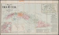
Includes text., Insets: [Spanish territory in Western Hemisphere]--City of Habana--Province of Havana., Relief shown by hachures., and Shows railroads, provinces, roads, light houses, and territory held by Spain.
Publisher:
J.L. Smith,
Subject (Geographic):
Cuba., Cuba--Maps., and Spain--Colonies--Cuba--Maps.