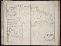
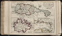
The English pilot: describing the West-India navigation, from Hudson's-Bay to the river Amazones
Image Count:
1
Subject (Geographic):
Atlantic Ocean --Maps --Early works to 1800, Jamaica --Maps --Early works to 1800, Port Royal (Jamaica) --Maps --Early works to 1800, and West Indies --Maps --Early works to 1800
Subject (Topic):
Navigation --Early works to 1800, Pilot guides --Atlantic Coast (U.S.) --Early works to 1800, and Pilot guides --Caribbean Area --Early works to 1800
Collection Created:
London : Printed for Thomas Page, William and Fisher Mount, in Postern-Row on Tower-hill, MDCCXXV [1725]
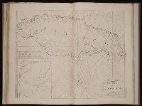
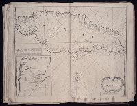
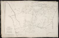
The English pilot: describing the sea-coasts, capes, head-lands, rivers, bays, roads, havens
Image Count:
1
Description:
Most maps numbered in pencil on verso, some on recto.
Subject (Geographic):
Atlantic Ocean --Maps --Early works to 1800, Jamaica --Maps --Early works to 1800, and West Indies --Maps --Early works to 1800
Subject (Topic):
Navigation --Early works to 1800, Pilot guides --Atlantic Coast (U.S.) --Early works to 1800, and Pilot guides --Caribbean Area --Early works to 1800
Collection Created:
London : Printed for John Thornton, at the sign of the England, Scotland, and Ireland, in the Minories, and Richard Mount, at the Postern on Tower-Hill, 1698London : Printed for John Thornton, at the sign of the England, Scotland, and Ireland, in the Minories, and Richard Mount, at the Postern on Tower-Hill, 1698
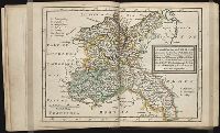
Also appeared in Kitchin's General atlas describing the whole universe. London : Printed Robert Sayer and J. Bennet, 1773; and General atlas describing the whole universe. London : Printed and sold for R. Sayer and J. Bennet, 1780., Ferro meridian., Ms. notes on, and newspaper clipping pasted to, verso. No. 14 of 43 maps bound together in composite atlas., Relief shown pictorially., Scale [1:2,300,000]., and Shows boundaries, rivers and settlements.
Publisher:
Printed for Rob. Sayer
Subject (Geographic):
Iberian Peninsula, Portugal --Maps --Early works to 1800, and Spain --Maps --Early works to 1800
Allan, A., Capt Beatson, Alexander, 1759-1833 Harmar, Thomas Rennell, James, 1742-1830, creator
Published / Created:
1792 February 21
Call Number:
1982 Folio 10
Image Count:
1
Description:
Compiled from the original maps, drawn by Capt. A. Beatson and Capt. A. Allan ; with some particulars added in explanation by J. Rennell ; plan work by I. Walker ; writing by T. Harmar., Map with relief shown pictorially., No. 33 of 43 maps bound together in composite atlas., and Scale [ca. 1:750,000].
Publisher:
J. Rennell
Subject (Geographic):
India, South --History, Military --Maps --Early works to 1800
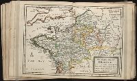
Twenty four new and accurate maps of the several parts of Europe ... : all (except the last) new
Image Count:
1
Alternative Title:
The north-east part of Germany, containing the dutchies of Mecklenburg and Pomerania, Brandenburgh, Saxony, Silesia, the marquisate of Lusatia, &c
Description:
In pencil on verso: 8.
Subject (Geographic):
Brandenburg (Brandenburg, Germany) --Maps --Early works to 1800, Germany --Maps --Early works to 1800, Lusatia (Germany) --Maps --Early works to 1800, Mecklenburg (Germany : Region) --Maps --Early works to 1800, Pomerania (Poland and Germany) --Maps --Early works to 1800, Saxony (Germany) --Maps --Early works to 1800, and Silesia, Lower (Poland and Germany) --Maps
Subject (Name):
Barker, B. (Benjamin), d. 1764, bookseller, Clements, Henry, d. 1719, bookseller, King, Charles, d. 1735, bookseller, Nicholson, John, d. ca. 1717, bookseller, Parker, Richard, fl. 1692-1725, bookseller, and Tooke, Benjamin, d. 1716, bookseller
Subject (Topic):
Atlases --Early works to 1800
Collection Created:
[London] : Sold by J. Nicholson at the King’s-Arms in Little Britain, Benj. Barker and Charles King ..., Benj. Tooke ..., Hen. Clements ..., R. Parker and Ralph Smith under the Royal-Exchange ..., [1715?]
Twenty four new and accurate maps of the several parts of Europe ... : all (except the last) new
Image Count:
1
Alternative Title:
The north part of France, viz. Picardy, Normandy, Bretagne, Isle de France, Champagne and Orleanois
Description:
In pencil on verso: 16.
Subject (Geographic):
Champagne-Ardenne (France) --Maps, France --Maps --Early works to 1800, Normandy (France) --Maps --Early works to 1800, and Picardy (France) --Maps
Subject (Name):
Barker, B. (Benjamin), d. 1764, bookseller, Clements, Henry, d. 1719, bookseller, King, Charles, d. 1735, bookseller, Nicholson, John, d. ca. 1717, bookseller, Parker, Richard, fl. 1692-1725, bookseller, and Tooke, Benjamin, d. 1716, bookseller
Subject (Topic):
Atlases --Early works to 1800
Collection Created:
[London] : Sold by J. Nicholson at the King’s-Arms in Little Britain, Benj. Barker and Charles King ..., Benj. Tooke ..., Hen. Clements ..., R. Parker and Ralph Smith under the Royal-Exchange ..., [1715?]