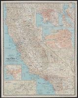
National Geographic Society (U.S.). Cartographic Section
Published / Created:
1954
Call Number:
844 1954
Container / Volume:
BRBL_00603
Image Count:
1
Resource Type:
Maps, Atlases & Globes
Description:
"Compiled by R.J. Darley, R.G. Fritz, A.D. Grazzini, R.E. McAleer, R.W. Northrop, W.T. Peele, F.W. Sheppard, and C.L. Stern. Physiography by J.J. Brehm and A.E. Holdstock. Typography by C.E. Riddiford." and Ancillary maps: Los Angeles [Scale 1:380,160] -- San Francisco Bay region [Scale 1:380,160] -- San Francisco [Scale ca. 1:41,000] -- San Diego [Scale 1:190,080] -- Yosemite Valley, Yosemite National Park [Scale 1:63,360].
Publisher:
National Geographic Society,
Subject (Geographic):
California--Maps
Subject (Name):
Brehm, J. J, Darley, Richard J, Fritz, R. G, Grazzini, Athos D, Holdstock, A. E, McAleer, Ralph E, Northrop, R. W, Peele, William T, Riddiford, Charles E, and S
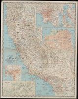
Big Black River Valley, Mississippi showing proposed plan of flood control, Bulletin of the U.S. Department of Agriculture ; no. 181, Drainage investigations, and Watershed map of Big Black River, Mississippi, and index of map, figure 10
Description:
"April 12, 1915.", Caption title., Imperfect: text wanting; maps only., and Nine folded maps, two folded charts inserted.
Publisher:
U.S. Dept. of Agriculture,
Subject (Geographic):
Mississippi--Maps
Subject (Name):
Ramser, C. E. (Charles Ernest), b. 1885 and Schlick, W. J. (William Japhia), 1887-
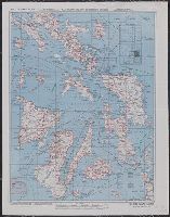
Chart No. C-42, Samar Island, No. C41, Mindoro Island, and Philippine series
Description:
Includes index to sheets, wind force and steadiness of direction of currents., On verso: Chart No. C-42, Samar Island., and Relief shown by gradient tints, contours, and spot heights.
Publisher:
Aeronautical Chart Service,
Subject (Geographic):
Mindoro (Philippines)--Maps and Samar Island (Philippines)--Maps
Subject (Topic):
Aeronautical charts--Philippines--Mindoro--Maps, Aeronautical charts--Philippines--Samar--Maps, Military geography--Philippines--Mindoro--Maps, Military geography--Philippines--Samar--Maps, and World War, 1939-1945-
National Geographic Society (U.S.). Cartographic Section
Published / Created:
c1943.
Call Number:
60 1943
Container / Volume:
BRBL_00329
Image Count:
1
Resource Type:
Maps, Atlases & Globes
Description:
"International boundaries as of Sept. 1, 1939.", Includes a chart of airline distances., Inset: Relief. Scale 562 miles to 1 inch., Issued with the National Geographic magazine, v. 83, no. 2, February 1943., and Relief shown by hachures and spot heights.