[Atlas nouveau contenant toutes les parties du monde ou sont exactement marques les empires
Image Count:
1
Resource Type:
Maps, Atlases & Globes
Abstract:
Factitious collection of about 549 maps taken from the atlases of the 17th and the beginning of the 18th century, put together with the title "Atlas" and bound in 6 volumes. These volumes originally bore the imprint: Amstelaedamii apvd Reiniervm & Josvam Ottens. Over these words on the title pages of volumes 1-2 and 4-6 is the name of Henrik de Leth who painted them.
Description:
Verso blank.
Subject (Geographic):
British Isles --Maps --Early works to 1800
Subject (Name):
Leth, Hendrik de, 1703-1766, Reiner et Josua Ottens (Firm), Schenck, Peter, 1661-1715, Schenck, Peter, ca. 1698-1752, Valck, G. (Gerard), 1651 or 2-1726, and Wit, Frederik de
Subject (Topic):
Atlases --Early works to 1800
Collection Created:
[A Amsterdam, chez J. Covens & C. Mortier, ca. 1730-ca. 1800]
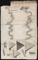
Forty-two new maps of Asia, Africa, and America ... : all engrav’d, according to the latest
Image Count:
1
Alternative Title:
The River Nile, with all the pyramids
Description:
Imperfect: tear at bottom center fold with no loss of text., In ink on verso: 15., and Includes "The draught of ye pyramids taken exactly from Mr. Greaves".
Subject (Geographic):
Africa --Maps --Early works to 1800 and Nile River
[Atlas factice of 32 maps and 1 distance table, produced by the Homann Erben firm]
Image Count:
2
Alternative Title:
Belgium Catholicum seu decem provinciae Germaniae inferioris and Carte des Pais Bas catholiques ou des X provinces de l’Allegmagne inferieure, etc. dessinee au juste selon les exactes observations astronomiques et operations geometriques des Messur. Cassini, Snellius, Muschenbrok, etc. dressee par Sr. Tobias Maier, mathematicien; aux depens des Heritiers de Homann
Subject (Geographic):
Belgium --Maps --Early works to 1800 and Luxembourg --Maps --Early works to 1800