Skip to search
Skip to main content
Skip to first result
Search
You Searched For
Format
cartographic
Subject (Name)
Bien, Julius, 1826-1909
Subject (Name)
Roeser, C. (Charles)
New Search
Search Results
Creator:
Published / Created:
[1878?].
Call Number:
75 1878
Container / Volume:
BRBL_00406
Image Count:
16
Resource Type:
Maps, Atlases & Globes
Alternative Title:
Centennial map of the United States and territories and Centennial map of the United States, 1879.
Description:
Imperfect: Sheet 5 wanting., In portfolio., and Relief shown by hachures.
Publisher:
J. Bien,
Subject (Geographic):
United States--Maps
Subject (Name):
Bien, Julius, 1826-1909, Roeser, C. (Charles), United States. General Land Office, and Woods, William L
Found in:
Beinecke Rare Book and Manuscript Library > 1876 Centennial map of the United States and territories : showing the extent of public surveys, indian and military reservations, land grant R.R. rail roads, canals, cities, towns & other details / compiled from the official surveys of the General Land O
Creator:
Published / Created:
1876
Call Number:
75 1876
Container / Volume:
BRBL_00405
Image Count:
6
Resource Type:
Maps, Atlases & Globes
Description:
Insets: Alaska and Aleutian Islands. and Relief shown by hachures.
Publisher:
Photolith. and printed by J. Bien,
Subject (Name):
Bien, Julius, 1826-1909 and Roeser, C. (Charles)
Subject (Topic):
Canals--United States--Maps, Indian reservations--United States--Maps, Military reservations--United States--Maps, Railroad land grants--United States--Maps, Railroads--United States--Maps, and Surveying-
Found in:
Beinecke Rare Book and Manuscript Library > Map of the United States and territories, showing the extent of public surveys, Indian and military reservations, land grant R.R., rail roads, canals, and other details / compiled from the official surveys of the General Land Office, and other authentic s
Creator:
Published / Created:
1878
Call Number:
818 1878
Container / Volume:
BRBL_00565
Image Count:
1
Resource Type:
Maps, Atlases & Globes
Description:
"J. A. Williamson, Commissioner"., Gives longitude west from Washington and Greenwich., and Relief shown by hachures.
Publisher:
General Land Office.,
Subject (Geographic):
Arkansas--Maps
Subject (Name):
Bien, Julius, 1826-1909 and Roeser, C. (Charles)
Found in:
Beinecke Rare Book and Manuscript Library > State of Arkansas / compiled from the official records of the General Land Office and other sources by C. Roeser, Principal Draughtsman, GLO, Department of the Interior.
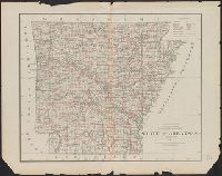
Creator:
Published / Created:
1878
Call Number:
815 1878
Container / Volume:
BRBL_00560
Image Count:
1
Resource Type:
Maps, Atlases & Globes
Description:
Prime meridians: Greenwich and Washington., Relief shown by hachures., and Shows county boundaries, towns and railroads.
Publisher:
General Land Office,
Subject (Geographic):
Iowa--Maps
Subject (Name):
Bien, Julius, 1826-1909 and Roeser, C. (Charles)
Found in:
Beinecke Rare Book and Manuscript Library > State of Iowa / Department of the Interior, General Land Office, J.A. Williamson, Commissioner ; compiled from the official records of the General Land Office and other sources by C. Roeser, Principal Draughtsman, G.L.O.
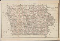
Creator:
Published / Created:
1879
Call Number:
795 1879
Container / Volume:
BRBL_00521
Image Count:
1
Resource Type:
Maps, Atlases & Globes
Description:
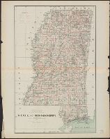
"J.A. Williamson, Commissioner.", Prime meridians: Washington and Greenwich., and Shows county boundaries and county seats, private grants, etc.
Publisher:
The Office,
Subject (Geographic):
Louisiana--Maps
Subject (Name):
Bien, Julius, 1826-1909 and Roeser, C. (Charles)
Found in:
Beinecke Rare Book and Manuscript Library > State of Louisiana / compiled from the official records of the General Land Office and other sources by C. Roeser, Principal Draughtsman, G.L.O.
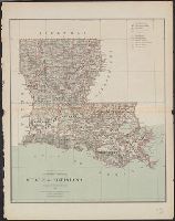
Creator:
Published / Created:
1879
Call Number:
837 1879
Container / Volume:
BRBL_00594
Image Count:
1
Resource Type:
Maps, Atlases & Globes
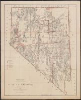
Description:
"J.S. Williamson, Commissioner.", Prime meridans: Greenwich and Washington., Relief shown by hachures., and Shows drainage, county boundaries, railroads, military & Indian reservations, townships, etc.
Publisher:
General Land Office,
Subject (Geographic):
Nevada--Maps and Nevada--Surveys--Maps
Subject (Name):
Bien, Julius, 1826-1909 and Roeser, C. (Charles)
Found in:
Beinecke Rare Book and Manuscript Library > State of Nevada / compiled from the official records of the General Land Office and other sources by C. Roeser, Principal Draughtsman, G.L.O.
Branch:v1.64.0 ,Deployed:2024-09-11T10:25:40-04:00