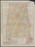
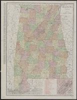
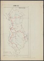
Rand McNally & Co.'s indexed county and township pocket map and shippers' guide of Alabama and Rand McNally and Co.'s indexed county and township pocket map and shippers' guide of Alabama
Description:
Includes key to railroads numbered 1-160 (with gaps in numbering) beneath added title: Alabama railroads., Inset (12 x 11 cm.): Environs of Birmingham., and Without accompanying index. Numerous cities on map with printed circles.
National Geographic Society (U.S.). Cartographic Division
Published / Created:
1983
Call Number:
848 1983
Container / Volume:
BRBL_00631
Image Count:
2
Resource Type:
Maps, Atlases & Globes
Alternative Title:
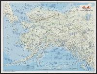
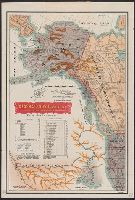
The making of America: Alaska.
Description:
"Supplement to the National Geographic, January 1984, page 50A, vol. 165, no. 1.", Inset: Continuation of the Aleutian Islands on same scale as main map., Relief shown by shading and spot heights., Text, maps, ill. on verso., and Title when folded: The making of America: Alaska.
"No. 20"--Upper right margin., "The Yukon River, ranges of mountains, shores of Norton Sound and many features of the interior from a reconnaissance by W.H. Dall, Director of the Scientific Corps, of the W.U. Tel. Expedition, 1865-1868.", and Inset: Aleutian Islands.
Publisher:
U.S. Coast Survey,
Subject (Geographic):
Alaska--Maps and Yukon Territory--Maps
Subject (Name):
Dall, William Healey, 1845-1927 and Lindenkohl, H. (Henry)
Great Britain. Royal Air Force. Central Interpretation Unit
Published / Created:
1943
Call Number:
475 1944
Container / Volume:
BRBL_00262
Image Count:
1
Resource Type:
Maps, Atlases & Globes
Alternative Title:
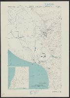
Geographical Section, General Staff ; no. 4415, GSGS (Series) ; 4415., and Vlonë (Valona) city plan
Description:
"1-44.", "1943.", "First G.S.G.S. edition, 1943.", "Ground information supplied by I.S.T.D.", "War Office 1943.", Inset: [Krionero]., Military grid., and Relief shown by contours, land form drawings, and one spot height.
"War Office, November 1918." and Red overprint: At head of map, "Map No.1, Portion of sheets Sofiya & Athenai. International Map 1:1,000,000"; on body of map, reference chart showing land claims corresponding to lines on map; at bottom left margin, "Geographi