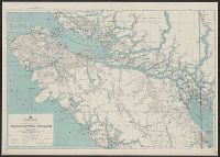
A.M.S. ; 6201 and Series (Standard map series designation system) ; 6201.
Description:
Elevations are shown by hachures and spot heights in meters., Inset with detailed transportation information., and Two classes of roads and eight classes of railroads are shown.
Publisher:
The Service,
Subject (Topic):
Transportation--Finland--Maps and Transportation--Sweden--Maps
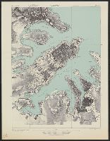
[Series] M991, Malta 1:7,500, Malta 1:7,500., and Valletta
Description:
"A.M.S. M991.", "Copied from British Admiralty H.O. chart no. 974.", "First edition 1943.", 3-43.", Relief shown by form lines., and Some streets and other features are named.
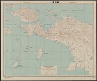
AMS ; A521 and Series (Standard map series designation system) ; A521.
Description:
Map originallly published by British Columbia Dept. of Lands., Northerly portion Vancouver Island, 1929, Map No. 2C -- Southerly portion Vancouver Island, 1938, Map No. 2A., Relief shown by s, and South sheet contains index map, location map, and mileage charts.