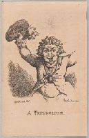
"Half length portrait of a man full faced with raised arms and frenzied expression, waving a hat with a large election favour, a second favour on his coat, and a medallion hung from his neck."--British Museum catalogue.
Description:
Numbered "10" in upper right corner., Plate from: A lecture on heads / by Geo. Alex. Stevens ; with additions, as delivered by Mr. Charles Lee Lewes ; ... embellished with twenty-five humourous characteristic prints, from drawings by G.M. Woodward, Esq. London : Printed for Vernor, Hood, and Sharpe ..., 1808., Publisher and date of publication from engraved frontispiece to the volume; see no. 11155 in the Catalogue of prints and drawings in the British Museum. Division I, political and personal satires, v. 8., and Title etched below image.
Publisher:
Thos. Tegg, No. 111 Cheapside
Subject (Name):
Auchincloss, Hugh Dudley--Ownership., Harvey, Francis--Ownership., Stevens, George Alexander,--1710-1784.--Lecture on heads., Tegg, Thomas, 1776-1845, publisher., and Woodward, G. M. (George Moutard), approximately 1760-1809, artist.
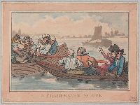
"A Thames pair-oar wherry, with two passengers, a man and woman, is about to collide with a sturdier boat in which are three men and a stout trollop, whose shouts and gesture shock the passengers in the wherry. The river is wide, with trees on the opposite shore and a sailing-barge in the middle distance."--British Museum online catalogue, description of variant state.
Alternative Title:
Freshwater salute
Description:
Date from Grego., For variant state with artist's signature, see no. 9464 in the Catalogue of prints and drawings in the British Museum. Division I, political and personal satires, v. 7., Rowlandson attribution from artist's signature on variant state: Rowlandson delt., and Title etched below image.
Subject (Name):
Auchincloss, Hugh Dudley--Ownership., Harvey, Francis--Ownership., and Rowlandson, Thomas, 1756-1827, artist.
Subject (Topic):
Caricatures and cartoons --England and Satires (Visual works) --England
The English pilot: describing the sea-coasts, capes, head-lands, rivers, bays, roads, havens
Image Count:
1
Description:
Most maps numbered in pencil on verso, some on recto.
Subject (Geographic):
Atlantic Ocean --Maps --Early works to 1800 and West Indies --Maps --Early works to 1800
Subject (Topic):
Navigation --Early works to 1800, Pilot guides --Atlantic Coast (U.S.) --Early works to 1800, and Pilot guides --Caribbean Area --Early works to 1800
Collection Created:
London : Printed for John Thornton, at the sign of the England, Scotland, and Ireland, in the Minories, and Richard Mount, at the Postern on Tower-Hill, 1698London : Printed for John Thornton, at the sign of the England, Scotland, and Ireland, in the Minories, and Richard Mount, at the Postern on Tower-Hill, 1698
The English pilot: describing the West-India navigation, from Hudson's-Bay to the river Amazones
Image Count:
1
Description:
Imperfect: mutilated with some loss of image.
Subject (Geographic):
Africa, West --Maps --Early works to 1800, Atlantic Ocean --Maps --Early works to 1800, New England --Maps --Early works to 1800, Newfoundland and Labrador --Maps --Early works to 1800, Portugal --Maps --Early works to 1800, South America --Maps --Early works to 1800, and West Indies --Maps --Early works to 1800
Subject (Topic):
Navigation --Early works to 1800, Pilot guides --Atlantic Coast (U.S.) --Early works to 1800, and Pilot guides --Caribbean Area --Early works to 1800
The English pilot: describing the West-India navigation, from Hudson's-Bay to the river Amazones
Image Count:
1
Resource Type:
Maps, Atlases & Globes
Subject (Geographic):
Africa, West --Maps --Early works to 1800, Atlantic Ocean --Maps --Early works to 1800, New England --Maps --Early works to 1800, Newfoundland and Labrador --Maps --Early works to 1800, Portugal --Maps --Early works to 1800, South America --Maps --Early works to 1800, and West Indies --Maps --Early works to 1800
Subject (Topic):
Navigation --Early works to 1800, Pilot guides --Atlantic Coast (U.S.) --Early works to 1800, and Pilot guides --Caribbean Area --Early works to 1800
Collection Created:
London : Printed for W. and J. Mount, T. Page and son, on Tower-Hill, MDCCLIX [1759]
Northern British Colonies and Seat of war, in the northern colonies, containing the province of Quebec, Newfoundland, Nova-Scotia, New-England, New-York, New-Jersey, Pennsylvania, and Maryland
Description:
For variant (earlier) issue of map, see B.B. McCorkle, New England in early printed maps, 776.11., From Robert Sayer and John Bennett's American military pocket atlas (1776)., Relief shown pictorially., and Watermark.
Subject (Geographic):
Canada--Maps--Early works to 1800 and New England--Maps--Early works to 1800
Subject (Name):
Holland, Samuel, 1728-1801, Pownall, Thomas, 1722-1805, and Robert Sayer and John Bennett (Firm). American military pocket atlas
Northern British Colonies and Seat of war, in the northern colonies, containing the province of Quebec, Newfoundland, Nova-Scotia, New-England, New-York, New-Jersey, Pennsylvania, &ca.
Description:
From Robert Sayer and John Bennett's American military pocket atlas (1776)., Imperfect: torn at bottom middle along fold, with some loss of text. Manuscript number of vero: 3., Relief shown pictorially., and Watermark.
Subject (Geographic):
Canada--Maps--Early works to 1800 and New England--Maps--Early works to 1800
Subject (Name):
Holland, Samuel, 1728-1801, Pownall, Thomas, 1722-1805, and Robert Sayer and John Bennett (Firm). American military pocket atlas
The English pilot: describing the sea-coasts, capes, head-lands, rivers, bays, roads, havens
Image Count:
1
Description:
Most maps numbered in pencil on verso, some on recto.
Subject (Geographic):
Africa --Maps --Early works to 1800, Atlantic Ocean --Maps --Early works to 1800, Canada --Maps --Early works to 1800, Central America --Maps --Early works to 1800, Great Britain --Maps --Early works to 1800, Newfoundland and Labrador --Maps --Early works to 1800, North America --Maps --Early works to 1800, South America --Maps --Early works to 1800, Spain --Maps --Early works to 1800, and West Indies --Maps --Early works to 1800
Subject (Topic):
Navigation --Early works to 1800, Pilot guides --Atlantic Coast (U.S.) --Early works to 1800, and Pilot guides --Caribbean Area --Early works to 1800
Collection Created:
London : Printed for John Thornton, at the sign of the England, Scotland, and Ireland, in the Minories, and Richard Mount, at the Postern on Tower-Hill, 1698London : Printed for John Thornton, at the sign of the England, Scotland, and Ireland, in the Minories, and Richard Mount, at the Postern on Tower-Hill, 1698
The English pilot: describing the West-India navigation, from Hudson's-Bay to the river Amazones
Image Count:
2
Description:
Mathematical notations on one verso.
Subject (Geographic):
Africa, West --Maps --Early works to 1800, Atlantic Coast (North America) --Maps --Early works to 1800, Atlantic Ocean --Maps --Early works to 1800, Newfoundland and Labrador --Maps --Early works to 1800, South America --Maps --Early works to 1800, and West Indies --Maps --Early works to 1800
Subject (Topic):
Navigation --Early works to 1800, Pilot guides --Atlantic Coast (U.S.) --Early works to 1800, and Pilot guides --Caribbean Area --Early works to 1800
Collection Created:
London : Printed for W. and J. Mount, T. Page and son, on Tower-Hill, MDCCLX [1760]