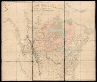
BEIN 71 1820B: Dissected and mounted on linen., Relief shown by hachures., "Additions to 1814" underneath "humble" in title., and "Additions to 1802" follows publication statement at bottom of map.
Publisher:
Published Jan. 1, 1795 by A. Arrowsmith, No. 10 Soho Square
Title supplied by cataloger., Nineteenth century forgery of a portlan chart., Manuscript note in accompanying case: A manuscript portolan on vellum probably executed by a Spanish chartmaker circa 1550, the coasts outlined in green with place names in gothic letters of red and black, decorated with devices of the sun and moon in umber heightened with gold, 14 x 9 inches. This chart is a rare example from its unusally small size. RH. 7487., and Pen and ink wash color on parchment, in Italian, in unidentified hand.
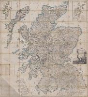
Scotland drawn and engraved from a series of angles and astronomical observations
Description:
Title from cartouche., Engraved throughout., Relief shown by contour lines and pictures., Scale of miles 69 1/2 to a degree., Another imprint: "Published according to Act of Parliament Jan. 1st. 1789 by John Ainslie ... and William Faden ..." at bottom of sheet., Inset maps: "Shetland Islands laid down upon a less scale than the map ... "; "A Map of the Orkney Islands ...", Distance tables and lists of heights of hills and roads from Edinburgh to London., Edinburgh meridian, with note of degrees from Greenwich., Title cartouche shows men fishing and herding cattle, with sheep goats and foliage., Six compass roses., This issue not in Chubb, T. Printed maps in the atlases of Great Britain and Ireland., and Scotland.
Publisher:
Printed and sold by the proprietor Thomas Brown, North Bridge Street, Edinburgh and Publish'd according to Act of Parliament with improvements till 1800 by Thomas Brown ... Edinburgh and William Faden ... London
Subject (Geographic):
Scotland, Orkney (Scotland), Shetland (Scotland), Scotland., Orkney., and Shetland.
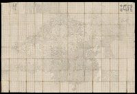
Bankoku ichiranzu, Bankoku ichiran zusetsu, and (Explanation of the visualized map of all the countries)
Description:
BEIN 2018 +512: Manuscript annotations in English on margins of map., Cover attached; cover and map title the same., Accompanied by: BANKOKU ICHIRAN ZUSETSU : (Explanation of the visualized map of all the countries) / Koyano Yoshiharu. -- Bunka 7 : (1810). -- 2 v., ill. ; 25.2 x 18 cm., Kôzanrō is a private school of Koyano Yoshiharu., and California shown as an island.
Publisher:
Kôzanrô, (June, 1809)
Subject (Geographic):
Japan and Japan.
Subject (Topic):
World maps, Geography, Study and teaching, and Prints, Japanese
Title supplied by cataloger. and "This book of charts was taken out of a Chinese trading junk of between 400 & 500 tons burden, trading from the gulf of Pechili in China to the straits of Singapore, by Philip Bean, of H.M.S. Herald, in the year of 1841; the junk being taken as a seige by the 'Herald'"--inscription from front free endpaper in 19th century hand.