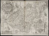
... Iohn Hvighen van Linschoten. his Discours of Voyages into ye Easte & West Indies. Deuided into
Image Count:
1
Description:
[Scale ca. 1:19,000,000]., Bound in following p. 216., In ink on verso: "197" in upper left corner, which has also been crossed out in ink with three lines., Map has been repaired with tape on verso., Map has one vertical tear just left of center., Map has several small brown and yellow marks that can be seen mostly on verso., and Map properly belongs to the Dutch edition of 1596.
Subject (Geographic):
Brazil --Maps --Early works to 1800, Chile --Maps --Early works to 1800, Cuba --Maps --Early works to 1800, Florida --Maps --Early works to 1800, Peru --Maps --Early works to 1800, South America --Maps --Early works to 1800, Tierra del Fuego (Argentina) --Maps --Early works to 1800, and West Indies --Maps --Early works to 1800
Subject (Topic):
Voyages and travels --Early works to 1800
Collection Created:
Printed at London by Iohn Wolfe Printer to ye Honorable Cittie of London [1598]
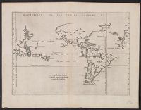
From Herrera y Tordesillas's Descripción de las Indias Occidentales ... Amstelodami : Apud M. Colinium, 1622., Map of the World from China, west to Spain showing the 'Merida, Relief shown pictorially., and Sheet measures 28.5 x 36.9 cm. Cross Collection no. 112.
Publisher:
Michiel Colijn,
Subject (Geographic):
World maps--Early works to 1800
Subject (Name):
Colijn, Michiel, Herrera y Tordesillas, Antonio de, d. 1625. Descripción de las Indias Occidentales. Latin, and Portugal.--Treaties, etc.--Spain--(1494 June 7)
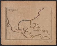
Appears in French eds. of Herrera y Tordesilla's Descripción de las Indias Occidentales published in Amsterdam., Sheet measures 28.7 x 35.2 cm. Cross Collection no. 227., and Shows coasts of the southern part of North America, Central America, northern coast of South America, and West Indies.
Publisher:
s.n. ,
Subject (Name):
Herrera y Tordesillas, Antonio de, d. 1625. Descripción de las Indias Occidentales. French
Subject (Topic):
Coasts--Central America--Maps--Early works to 1800, Coasts--North America--Maps--Early works to 1800, Coasts--South America--Maps--Early works to 1800, and Coasts--West Indies--Maps--Early works to 1800
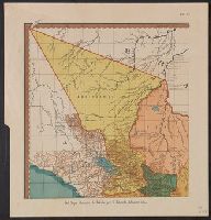
Color: pen with coasts outlined in grey watercolor, gold lettering., Invoice from H.P. Kraus Rare Books., and Lower Miss. Valley before New Orleans. 15 Indian Villages and French forts.
Subject (Geographic):
Mississippi River--Maps, Manuscript--Early works to 1800
Mexico. Dirección de Estudios Geográficos y Climatológicos
Published / Created:
[1922]
Call Number:
887 1922
Container / Volume:
BRBL_00655
Image Count:
2
Resource Type:
Maps, Atlases & Globes
Description:
"No. 9.", Accompanied by physiographic plate covering same area, showing only relief and drainage (1 sheet : col. ; 56 cm.)., Appears in Atlas geográfico de la República Mexicana., and Relief shown by shading.
Publisher:
La Dirección,
Subject (Geographic):
Distrito Federal (Mexico)--Maps
Subject (Name):
Mexico. Dirección de Estudios Geográficos y Climatológicos. Atlas geográfico de la República Mexicana