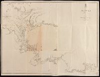
At head of title: Australia N.W. Coast., Coordinates not present on map and are approximated., Imperfect: mutilated and repaired, with no loss of text., In lower right corner: 1705., and Relief shown by hachures; soundings in fathoms.
Publisher:
Hydrographic Office of the Admiralty,
Subject (Geographic):
Victoria River (N.T.)--Maps. and Victoria River (N.T.)--Navigation--Maps.
Subject (Name):
Bate, R. B. (Robert Brettell), bookseller., Great Britain. Hydrographic Office, publisher., and J. & C. Walker (Firm), engraver.
From Thomas Jeffery's American atlas. 1778., Imperfect: southern portion of text torn along fold and separated. Sheets pasted together to form one map. No. "17" stamped on verso, upper right corner., Insets: A chart of the mouth of Hudson's River, from Sandy Hook to New York.--A plan of the city of New York.--Plan of Amboy, with its environs, from an actual survey., Prime meridian: London., Relief shown pictorially., Shows administrative divisions., and Watermarks.
Publisher:
Printed for Robt. Sayer & John Bennett ...,
Subject (Geographic):
New Jersey--Administrative and political divisions--Maps--Early works to 1800., New Jersey--Maps--Early works to 1800., New York (N.Y.)--Maps--Early works to 1800, New York (State)--Administrative and political divisions--Maps--Early works to 1800., Northeastern States, Northeastern States--Maps--Early works to 1800., Perth Amboy (N.J.)--Maps--Early works to 1800., and Québec (Province)--Maps--Early works to 1800
Subject (Name):
Holland, Samuel, 1728-1801 and Robert Sayer and John Bennett (Firm)
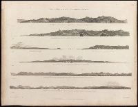
Voyage of discovery to the North Pacific ocean, and round the world.
Image Count:
1
Resource Type:
Maps, Atlases & Globes
Description:
Cape Mendocino ... / J. Sykes, delt. -- Cape Orford ... / J. Sykes -- Cape Orford bear[in]g. S.S.E. 10 miles distant / J. Sykes -- Cape Gregory -- Point Grenville ... / J. Sykes -- Entrance to the Straits of Juan de Fuca ... / H. Humphrys, delt. -- A continuation of the above coast s[out]hward. from Cape Flattery, Mount Olympus ... / H. Humphrys. and Seven views on 1 sheet.
Publisher:
Published May 1st, 1798, by R. Edwards, New Bond Street, J. Edwards Pall Mall & G. Robinson, Paternoster Row,
Subject (Name):
Alexander, William (1767-1816), Edwards, James, 1756-1816, Edwards, Richard, Humphrys, Henry, -1799, and Pouncy, Benjamin Thomas, d.
Subject (Topic):
Coasts--Northwest Coast of North America--Pictorial works--Early works to 1800.
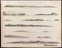
Voyage of discovery to the North Pacific ocean, and round the world.
Image Count:
1
Resource Type:
Maps, Atlases & Globes
Alternative Title:
Cape Colnett., Entrance of Port St. Diego., Entrance of Port St. Francisco., Point Pinos ... River Carmelo., Punto de los Reyes ... and the Bay of Sir Francis Drake., Santa Barbara., and Two remarkable mountains to the southward of St. Diego.
Description:
Punto de los Reyes ... and the Bay of Sir Francis Drake ... / H. Humphrys, delt. -- The entrance of Port St. Francisco ... / T. Heddington, delt.-- Point Pinos ... River Carmelo ... / H. Humphreys, delt. -- Santa Barbara ... / J. Sykes, delt. -- The entrance of Port St. Diego ... Punta de Loma ... / T. Heddington, delt. -- Two remarkable mountains to the southward of St. Diego / T. Heddington, delt. -- Cape Colnett ... / T. Heddington, delt. and Seven views on 1 sheet.
Publisher:
Published May 1st, 1798, by R. Edwards, New Bond Street, J. Edwards Pall Mall & G. Robinson, Paternoster Row,
Subject (Name):
Alexander, William (1767-1816), Edwards, James, 1756-1816, Edwards, Richard, Fittler, James, 1758-1835, and Robinson, George, 1736-18
Subject (Topic):
Coasts--California--Pictorial works--Early works to 1800. and Coasts--Mexico--Baja California (State)--Pictorial works--Early works to 1800.
Voyage of discovery to the North Pacific ocean, and round the world.
Image Count:
1
Resource Type:
Maps, Atlases & Globes
Description:
Six views on 1 sheet. and The westernmost of Scots Islands ... / T. Heddington, delt. -- Cape Scot ... / J. Sykes, delt. -- Woody Point ... / J. Sykes -- The entrance of Nootka Sound ... / H. Humphrys, delt. -- The entrance of Columbia River, Cape Disappointment ... / H. Humphrys -- Punto Barro de Arena ... / H. Humphrys.
Publisher:
Published May 1st, 1798, by R. Edwards, New Bond Street, J. Edwards Pall Mall & G. Robinson, Paternoster Row,
Subject (Name):
Alexander, William (1767-1816), Edwards, James, 1756-1816, Edwards, Richard, Heddington, Thomas, 1775 or 1776-1860, and Humphrys, Hen
Subject (Topic):
Coasts--Northwest Coast of North America--Pictorial works--Early works to 1800.
Voyage of discovery to the North Pacific ocean, and round the world.
Image Count:
1
Resource Type:
Maps, Atlases & Globes
Description:
Nine views in 10 segments on 1 sheet. and Tscherikow's Island ... / H. Humphries, delt. -- The entrance of Port Chatham, Cook's Inlet ... / T. Heddington -- Wingham's Island ... the w[es]t point of Kaye's Island ... & Cape Hammond ... / J. Sykes -- Cape Ommaney ... s[ou]th point of Coronation Island ... Mount Calder ... / J. Sykes -- Cape St. Lucas, [Baja] California ... / T. Heddington -- The Maria Islands lying off Port San Blas, Mexico ... T. Heddington -- Cape Corrientes ... -- The islet of Diego Ramirez to the s[ou]th of Cape Horn ... / J. Sykes -- The coast to the s[ou]th of Valparaiso, Point Quraumilla ... / J. Sykes.
Publisher:
Published May 1st, 1798, by J. Edwards Pall Mall & G. Robinson, Paternoster Row,
Subject (Geographic):
Pacific Coast (Mexico)--Pictorial works--Early works to 1800.
Subject (Name):
Alexander, William (1767-1816), Edwards, James, 1756-1816, Fittler, James, 1758-1835, Heddington, Thomas, 1775 or 1776-1860, and Humph
Subject (Topic):
Coasts--Alaska--Pictorial works--Early works to 1800. and Coasts--Chile--Pictorial works--Early works to 1800.