
You Searched For
« Previous
| 11 - 20 of 20 |
Next »
Search Results

12.
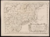
- Creator:
- Bellin, Jacques Nicolas, 1703-1772
- Published / Created:
- 1757
- Call Number:
- BrSides 2018 139
- Image Count:
- 1
- Resource Type:
- Maps, Atlases & Globes
- Description:
- "Tom. XIV. in 4°, no. 9. Tome 14. in 8°, page 97." in lower margin., Appears in Jean François de La Harpe's Abrégé de l'histoire générale des voyages. 1780., Covers the area from Penobscot Bay to Chesapeake Bay and west to Lake Erie., Prime meridian: Paris., Relief shown pictorially., Shows provices, towns, forts, rivers, Indian tribal territory, and relief., and Watermark.
- Publisher:
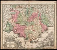
- [publisher not identified],
- Subject (Geographic):
- Middle Atlantic States--Maps--Early works to 1800. and New England--Maps--Early works to 1800.
- Subject (Name):
- La Harpe, Jean-François de, 1739-1803. Abrégé de l'histoire générale des voyages.
- Found in:
- Beinecke Rare Book and Manuscript Library > Carte de la Nouvelle Angleterre, Nouvelle Yorck, et Pensilvanie / pour servir à l'Histoire générale des voyages. Par M.B., ing. de la mare.
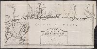
13.

- Published / Created:
- 1st June 1776.
- Call Number:
- 771cea N49 1776
- Container / Volume:
- BRBL_00493
- Image Count:
- 1
- Resource Type:
- Maps, Atlases & Globes
- Alternative Title:
- North-American pilot for New England, New York, Pensilvania, Maryland, and Virginia.
- Description:
- A Scale of 5 "English Miles" is given below the title at upper left., Below the scale: The Light-House of Sandy Hook is 40d. 27m. North Latitude., Coordinates not present on map and are approximated., Depths shown by soundings. Relief shown by hachures., First state., Includes note., Issued separately and in the first edition of Sayer & Bennett's North American Pilot for New England, New York, Pensilvania, Maryland, and Virginia. 1777., Sailing chart of the area around New York Harbor and Long Island; centered on Staten Island, York's Bay and Constable Point, extending north to Hells Gate, New York Island, Netwon Inlet, Bushwick Inlet, Wallabout Bay, Crown Point, the Battery and Ship Yards and south to the Shrewsbury River. The map extends East to include Amboy and the Raritan River, noting (Samuel?) Holland's House and east to Jamaica Bay and Plumb Island., and Watermarks.
- Publisher:
- Printed for Robt. Sayer & John Bennett, sea chart & map-sellers, No. 53, in Fleet Street. Published as the Act directs,
- Subject (Geographic):
- Atlantic Ocean--Lower Bay, Atlantic Ocean--Upper Bay, New Jersey--Sandy Hook, New York Harbor (N.Y. and N.J.) Maps--Early works to 1800., New York Region--Maps--Early works to 1800., and Sandy Hook (N.J.)
- Subject (Name):
- Robert Sayer and John Bennett (Firm), printmaker, printseller
- Subject (Topic):
- Nautical charts, Nautical charts--Hudson River Estuary (N.Y. and N.J.)--Early works to 1800., Nautical charts--Lower Bay (N.Y. and N.J.)--Early works to 1800., and Nautical charts--Upper Bay (N.Y. and N.J.)--Early works to 180
- Found in:
- Beinecke Rare Book and Manuscript Library > Chart of the entrance of Hudson's River, from Sandy Hook to New York [cartographic material] : with the banks, depths of water, sailing-marks, & ca.

- Creator:
- Ross, John, active 1762-1789
- Published / Created:
- 1 June 1775.
- Call Number:
- BrSides Folio 2018 122
- Image Count:
- 1
- Resource Type:
- Maps, Atlases & Globes
- Alternative Title:
- Course of the river Mississippi from the Balise to Fort Chartres
- Description:
- From Thomas Jeffery's The American atlas. 1775. Also published in Faden's North America Atlas, 1777., Imperfect: torn along fold. Title in manuscript on verso., Map of the Mississippi River Valley from the Gulf of Mexico to Fort Chartres, Illinois. Covers the Mississippi Valley from the Delta of the Mississippi where it joins the Gulf of Mexico to Fort Chartres., Prime meridian: New Orleans., Relief shown pictorially and by hachures. Depths shown by soundings., Scale of "Sea Leagues, 20 to a Degree"; and "British Miles, 69 1/2 to a Degree" below the imprint., Second issue. The first issue appeared in 1772. This 1775 issue has many changes in the area around New Orleans including the addition of forts St. Leon and St. Mary. Shows Baton Rouge and Lake Pontchartrain., The first official English survey of the Lower Mississippi, and one of the most historically significant American maps, delineating the British gains from France in the French and Indian War and later establishing the future western boundary of the new United States., The map includes detail of the lands to the immediate east of the Mississippi including numerous tributary rivers: the Pearl River, the Yasous River, the Chickasaw River, and the Ohio River. The locations of tribal lands and villages are noted, as well as alliances, roads to reach the villages, and the number of soldiers for several villages. Some tribes delineated in the map include the Arkansas, Chocktaw, Chicasaw, Yazoo, Wiapes, and Caskaskias., and Watermark.
- Publisher:
- Printed for Robt. Sayer, No. 53 in Fleet Street. Publishd as the Act directs,
- Subject (Geographic):
- Mississippi River Valley--Maps--Early works to 1800. and Mississippi River--Maps--Early works to 1800.
- Subject (Name):
- Jefferys, Thomas, -1771. American atlas. and Sayer, Robert, 1725-1794
- Found in:
- Beinecke Rare Book and Manuscript Library > Course of the river Mississipi [sic] from the Balise to Fort Chartres [cartographic material] ; taken on an expedition to the Illinois, in the latter end of the year 1765. / By Lieut. Ross of the 34th Regiment: Improved from the surveys of the river made
15.
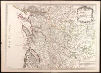
- Creator:
- Jaillot, Alexis Hubert, 1632?-1712
- Published / Created:
- 1722
- Call Number:
- BrSides Double Folio 2019 86
- Image Count:
- 1
- Resource Type:
- Maps, Atlases & Globes
- Description:
- Appeared in Alexis Hubert Jaillot's Atlas, Relief shown by hachures and pictorially., and Watermark.
- Publisher:
- Chez l'auteur, le Sr. Jaillot, Geographe ordinaire du Roy, avec Privilege de sa Majesté,
- Subject (Geographic):
- Charente-Maritime (France)--Administrative and political divisions--Maps--Early works to 1800. and Charente-Maritime (France)--Maps--Early works to 1800.
- Subject (Name):
- Haye, G. de la and Jaillot, Alexis Hubert, 1632?-1712. Atlas françois.
- Subject (Topic):
- Administrative and political divisions.
- Found in:
- Beinecke Rare Book and Manuscript Library > Generalité de La Rochelle divisée en cinq elections : sçavoir La Rochelle dans le pays d'Aunis, St. Jean d'Angely, Saintes, Marennes en Saintonge, Cognac en Angoumois : dressée sur les memoires les plus nouveaux / par le Sr. Jaillot ; Delahaye sculpsit.
16.
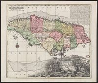
- Creator:
- Seutter, Matthaeus, 1678-1756, cartographer
- Published / Created:
- 1740?]
- Call Number:
- 8555 1740
- Container / Volume:
- BRBL_00642
- Image Count:
- 1
- Resource Type:
- Maps, Atlases & Globes
- Description:
- Appears in: Atlas novus, sive tabulae geographicae totius orbis faciem, partes, imperia et provincias exhibentes ... Augsburg : Matthaeo Seuttero, [1745?] 2 v. (Vol. 1, map no. 143)., Includes a large decorative cartouche showing natives processing sugar, flanked by turtles and a mermaid., and Relief shown pictorially; depths shown by soundings.
- Publisher:
- [M. Seutter,
- Subject (Geographic):
- Jamaica--Maps--Early works to 1800
- Subject (Name):
- Seutter, Matthaeus, 1678-1756. Atlas novus, sive tabulae geographicae totius orbis faciem, partes, imperia et provincias exhibentes
- Found in:
- Beinecke Rare Book and Manuscript Library > Nova designatio Insulae Jamaicae [cartographic material] : ex Antillanis Americae Septentrion. non postremae / secundum gubernationes suas accuratas aeri incisa et publici juris facta a Matthaeo Seuttero, Sac. Caes. et Reg. Cathol. Maj. Geogr.

- Creator:
- Anville, Jean Baptiste Bourguignon d', 1697-1782, cartographer
- Published / Created:
- [1767]
- Call Number:
- 50 1767
- Container / Volume:
- BRBL_00271
- Image Count:
- 1
- Resource Type:
- Maps, Atlases & Globes
- Description:
- Cartographer and publication date from dealer's notes., Country labels in French., Inset: Supplement pour l'Asie et l'Afrique., Relief shown pictorially., Shows most of the Middle East, and part of Egypt., Stamp on verso: 27., and Watermark.
- Publisher:
- [publisher not identified],
- Subject (Geographic):
- Middle East--Maps--Early works to 1800, Palestine--History--To 70 A.D.--Maps--Early works to 1800, and Palestine--Maps--Early works to 1800
- Subject (Name):
- Le Tellier, engraver
- Subject (Topic):
- Bible--Geography--Maps--Early works to 1800
- Found in:
- Beinecke Rare Book and Manuscript Library > Partie Orientale de la carte des anciennes monarchies [cartographic material] : omnis anima potestatibus sublimioribus subdita sit : non est enim potestas nisi à Deo : quae autem sunt, à Deo ordinatae sunt Aux Romains, ch. XIII. v.I / gravé par Le Tell
18.
- Creator:
- Bellin, Jacques Nicolas, 1703-1772, cartographer
- Published / Created:
- 1744
- Call Number:
- 85 1744
- Collection Title:
- Histoire et description generale de la Nouvelle France
- Container / Volume:
- BRBL_00731
- Image Count:
- 1
- Resource Type:
- Maps, Atlases & Globes
- Description:
- Lower left corner: 34., Prime meridian: Paris., Sheet measures 23 x 46 cm. Franklin Collection., and Watermark.
- Publisher:
- Pierre-François Giffart],
- Subject (Geographic):
- Alabama--Maps--Early works to 1800, Florida--Maps--Early works to 1800, Gulf Coast (U.S.)--Maps--Early works to 1800, Louisiana--Maps--Early works to 1800, and Mobile Bay (Ala.)--Maps--Early works to 1800
- Subject (Name):
- Charlevoix, Pierre-François-Xavier de, 1682-1761 and Giffart, Pierre François, 1677-1758
- Subject (Topic):
- Coasts--Alabama--Maps--Early works to 1800, Coasts--Florida--Maps--Early works to 1800, and Coasts--Louisiana--Maps--Early works to 1800
- Found in:
- Beinecke Rare Book and Manuscript Library > Partie de la coste de la Louisiane et de la Floride [cartographic material] : depuis le Mississipi jusqua S[t]. Marc d'Apalache / dressée sur les manuscrits du depost des plans de la Marine par N.B. Ing[r] du Roy et de la Marine.
19.
- Creator:
- Seutter, Matthaeus, 1678-1756
- Published / Created:
- [1740?]
- Call Number:
- BrSides Double Folio 2019 40
- Image Count:
- 1
- Resource Type:
- Maps, Atlases & Globes
- Alternative Title:
- Provence
- Description:
- "Cum Gratia et Privil. S.R.I. Vicariatus in partibus Rheni, Sveviae et juris Franconici.", Ornamental cartouche decorated with coats of arms and mythical figures., Relief shown pictorially., and Watermark. Manuscript number in right corner: 24. From the Karpinski-von Wieser Map Collection.
- Publisher:
- [Mattheus Seutter]
- Subject (Geographic):
- France--Provence-Alpes-Côte d'Azur, Provence-Alpes-Côte d'Azur (France)--Administrative and political divisions--Maps--Early works to 1800., and Provence-Alpes-Côte d'Azur (France)--Maps--Early works to 1800.
- Subject (Name):
- Rogg, Gottfried, 1669-1742
- Subject (Topic):
- Administrative and political divisions
- Found in:
- Beinecke Rare Book and Manuscript Library > Provincia Gallis la Provence dicta : determinata in omnes suas praefecturas cum terris confinibus et alluentib. Maris Mediterranei partibus / cura et caelo Matthaei Seutteri, S.C.M. Geogr. Augustani ; Gottfr. Rogg inv. et delin.
20.
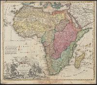
- Creator:
- Homann, Johann Baptist, 1663-1724
- Published / Created:
- 1730?]
- Call Number:
- 60 1730B
- Container / Volume:
- BRBL_00323
- Image Count:
- 1
- Resource Type:
- Maps, Atlases & Globes
- Description:
- Prime meridian: Tenerife. and Relief shown pictorially.
- Publisher:
- s.n.,
- Subject (Geographic):
- Africa--Administrative and political divisions--Maps--Early works to 1800, Africa--Maps--Early works to 1800, and Arabian Peninsula--Maps--Early works to 1800
- Found in:
- Beinecke Rare Book and Manuscript Library > Totius Africae nova repraesentatio, qua praeter diversos in ea status et regiones, etiam origo Nili ex veris rr. pp. missionariorum relationibus ostenditur / â Io. Baptista Homanno ... Norimbergae.