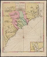
Backed with linen. Sheet measures 63.1 x 51.4 cm. 2nd copy shows different boundary for Colleton County., Bar scales given in "lieues de France et d'Angleterre," "lieues communes d'Allemagne," "lieues communes de Mer"., Prime meridian: Ferro., and Rel
Publisher:
Chez Pierre Mortier,
Subject (Geographic):
North Carolina--Maps--Early works to 1800 and South Carolina--Maps--Early works to 1800
Subject (Name):
Mortier, Pierre. Atlas nouveau and Mortier, Pierre. Suite du Neptune François
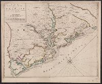
"Avec privilege de nos Seigneurs les Etats.", Bar scales given in "lieues de France et d'Anglete, Mounted on linen. Sheet measures 52.4 x 63.3 cm. Cross Collection no. 221., Relief shown pictorially; depths shown by soundings., and Shows names of property owners.
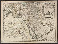
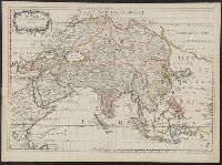
Estats de l'empire dv Grand Seignevr des Tvrqs ou Svltan des Ottomans en Asie, en Afriqve, et en Evrope
Description:
Bar scales given in "lieues com. France" and "mille pas geometri.", From Sanson's Cartes générales de toutes les parties du monde (1658)., Ms. number on verso: 48. Sheet measures 43.1 x 58.2 cm., Prime meridian: Ferro., Relief shown pictorially., and Watermark.
Publisher:
Chez l'autheur,
Subject (Geographic):
Middle East--Maps--Early works to 1800
Subject (Name):
Sanson, Nicolas, 1600-1667. Cartes générales de toutes les parties du monde
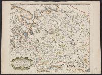
Estats du Czar ou Grand Dvc de la Rvssie Blanche ou Moscovie
Description:
Appeared in Sanson's Cartes générales de toutes les parties du monde., Lacks left border., Prime meridian: Ferro., Relief shown pictorially., Verso: Numbered "152", labeled "moscouie" in ink ms. Sheet measures 42.2 x 57.5 cm. Lada-Mocarski Collection., and Water
Publisher:
Chez l'auteur, avec privil. pour 20 ans aux Galleries du Louvre,
Subject (Geographic):
Europe, Eastern--Maps--Early works to 1800 and Russia--Maps--Early works to 1800
Subject (Name):
Peyrounin, A., engraver and Sanson, Nicolas, 1600-1667. Cartes générales de toutes les parties du monde
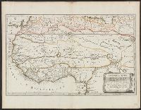
Appears in: Cartes générales de toutes les parties du monde ... / par le sieur Sanson d'Abbéville. Paris : Chez P. Mariette, 1658., Ms. number on verso: 118. Sheet measures 45.3 x 59.3 cm., Prime meridian: Ferro., Relief shown pictorially., and Watermark.
Publisher:
Chez Pierre Mariette ...,
Subject (Geographic):
Morocco--Maps--Early works to 1800
Subject (Name):
Mariette, Pierre, 1603-1657, Sanson, Nicolas, 1600-1667. Cartes générales de toutes les parties du monde, and Somer, Jan, engraver
Europe divided into its principall parts viz. the Brittish [sic] Islands, Scandinavia, Moscovia, France, Germany, Poland, Spain, Italy, Turky [sic] in Europe ... described by Sanson, corrected and amended by William Berry
Description:
Dedicated To the most serene and most sacred majesty of Charles II ... by William Berry., Includes coat of arms and decorative cartouche containing dedication., No. 2 of 69 maps bound together in composite atlas., Prime meridian: Ferro., Relief shown pictorially., and Scale [ca. 1:75 000 000].
Publisher:
Sold by William Berry at ye sign of the globe between Charing-Cross and White-Hall
Subject (Geographic):
Europe --Maps --Early works to 1800, Russia --Maps --Early works to 1800, and Turkey --Maps --Early works to 1800
Italy divided according as its severall principalities extend, which are the territories of the Church, of the Catholick king, which contain the kingdomes of Naples, Sicily, Sardinia, and the Dukedome of Millain ... described by Sanson, corrected and amended by Will. Berry
Description:
Bar scales given in Italian miles, common leagues of Germany, great German leagues, common leagues of France, great French leagues, and common leagues of Spain., Dedicated To the most serene and most sacred majesty of Charles II ... by William Berry., No. 16 of 69 maps bound together in composite atlas., Relief shown pictorially., and Scale [ca. 1:2 300 000].
Publisher:
Sold by William Berry at the signe of the Globe between Charing-Cross and White Hall
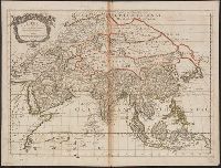
From Guillaume Sanson's Cartes générales de toutes les parties du monde., Prime meridian: Ferro., Relief shown pictorially., Sheet measures 45.5 x 59.9 cm. Bookplate: From the collection of Laura K. and Valerian Lada-Mocarski., and Watermark.
Publisher:
Chez Pierre Mariette, rue St. Iacques à l'Esperance, avec privilege de Sa Majte. pour 20 ans,
Subject (Geographic):
Asia--Maps--Early works to 1800
Subject (Name):
Lada-Mocarski, Laura K.--(Laura Klots),--1902-1997--Bookplate, Lada-Mocarski, Valerian,--1898-1971--Bookplate, Mariette, Pierre, 1634-1716, and Sanson, Guillaume. Cartes générales de toutes les parties du monde
"Avec privilege du Roy, pour vingt ans.", "La coste des Negres, et Guinee, &c. est apres les observations de Samuel Blomart.", Has watermark., Relief shown pictorially., and Verso: numbered "24" in ink in upper right corner.
Publisher:
Chez Pierre Mariette, rue St. Iacques a l'Esperance,
Subject (Geographic):
Africa, North--Maps--Early works to 1800 and Africa, West--Maps--Early works to 1800