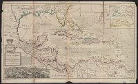
Insets: View of the City of Mexico with index, La Vera Cruz Harbor, Havana Harbor, The bay of Porto Bella, St. Agustin Harbor, Cartagena. and This edition apparently later than *85 1708A, as it has imprint Printed for Thomas Bowels ... and Ion Bowels ... [and] Sold by H. Moll and by I. Ring ...
Insets: View of the City of Mexico with index, La Vera Cruz Harbor, Havana Harbor, The bay of Porto Bella, St. Agustin Harbor, Cartagena. and This edition apparently later than *85 1708A, as it has imprint Printed for Thomas Bowels ... and Ion Bowels ... [and] Sold by H. Moll and by I. Ring ...
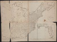
Includes eastern Connecticut ; Massachusetts as far north as Boston, including Cape Cod, Martha's Vineyard, and Nantucket ; and the eastern end of Long Island.
Alternative Title:
Colony of Rhode Island and Rhode Island
Description:
"London Magazine 1778"--Top margin., From The London Magazine (November 1778)., Publisher from bottom margin., Relief shown pictorially., and Sheet measures 21 x 28.4 cm. Inscription on verso: William Akers. Cross Collection no. 198.
Publisher:
Printed for R. Baldwin at the Rose, Pater Noster Row,
Subject (Geographic):
New England--Maps--Early works to 1800
Subject (Name):
Akers, William--Autograph and Baldwin, R. (Robert), 1737-1810
Papers relating to an act of the Assembly of the province of New-York, for encouragement of the
Image Count:
1
Alternative Title:
Map of the countrey of the Five Nations belonging to the province of New York and of the lakes near which the nations of far Indians live with part of Canada
Description:
Formerly bound preceding p. 1 of 2003 +64, now shelved separately as: Broadsides 2008 48.
Subject (Geographic):
Great Britain --Colonies --Commerce, Great Britain. Board of Trade, Great Britain. Sovereign (1714-1727 : George I), New York (State) --Commerce, New York (State) --Maps --Early works to 1800, New York (State). Act for encouragement of the Indian trade, and New York (State). Council
Subject (Name):
Colden, Cadwallader, 1688-1776 and L’Isle, Guillaume de, 1675-1726
Subject (Topic):
Fur trade --Canada, Fur trade --New York (State), and Indians of North America --Commerce
Collection Created:
[New York] : Printed and sold by William Bradford in the city of New-York, 1724
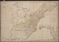
"Engraved on stone by Friend & Aub." and "The country on the eastern side of the Alleganey Mountains, is taken from Fry and Jefferson's Map of Virginia and Scull's Map of Pennsylvania ... that on the western side of the Alleganey, is taken from Hutchins ... a
Publisher:
J.W. Randolph,
Subject (Geographic):
Middle Atlantic States--Maps--Early works to 1800--Facsimiles
Subject (Name):
Friend & Aub and Randolph, Joseph Williamson, 1815-1893