- Creator:
- Schenk, Peter, 1660-1718 or 1719
- Published / Created:
- 1700?]
- Call Number:
- 331 1700A
- Container / Volume:
- BRBL_00078
- Image Count:
- 1
- Resource Type:
- Maps, Atlases & Globes
- Description:
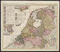
- "Cum privil.", Appears in Schenk's Atlas contractus ... [Amsterdam : Peter Schenk, ca. 1700]., Imperfect: Mutilated, with some loss of text. Sheet measures 53.5 x 62 cm. Verso: "19" (?) in ink ms., Insets: Batavorum colon, and Relief shown pictorially.
- Publisher:
- Peter Schenk?
- Subject (Geographic):
- East Indies--Maps--Early works to 1800, Netherlands--Maps--Early works to 1800, and New Netherland--Maps--Early works to 1800
- Found in:
- Beinecke Rare Book and Manuscript Library > Belgii pars septentrionalis communi nomine vulgo Hollandia : nuncupata continens statum potentissimae Batavorum Reipublicae seu Provincias VII. foederatas. Cum omnium provinciarum insignibus, additis omnibus nominibus urbium et pagorum edente / Petro Sche
You Searched For
1 - 7 of 7
Search Results
2.
- Creator:
- Robijn, Jacobus, d. ca. 1710
- Published / Created:
- 1687
- Call Number:
- 7855 1687
- Container / Volume:
- BRBL_00691
- Image Count:
- 1
- Resource Type:
- Maps, Atlases & Globes
- Description:
- Below title in cartouche: "Met privilegio voor 15 iaaren ao 1687.", Depths shown by soundings., Dutch and French., Inset map: Le partie du Carolina grand point., and Sheet measures 44.3 x 56.7 cm. Cross Collection no. 220.
- Publisher:
- s.n.],
- Subject (Geographic):
- Atlantic Coast (South Atlantic States)--Nautical charts--Early works to 1800 and South Carolina--Nautical charts--Early works to 1800
- Subject (Topic):
- Nautical charts--Atlantic Coast (South Atlantic States)--Early works to 1800 and Nautical charts--South Carolina--Early works to 1800
- Found in:
- Beinecke Rare Book and Manuscript Library > Caerte vande cust Carolina : tusschen B. de S Matheo en C. Henry / op niew verbeetert door Iacobus Robyn.
- Creator:
- Linschoten, Jan Huygen van, 1563-1611
- Published / Created:
- 1596?]
- Call Number:
- 63 1596
- Container / Volume:
- BRBL_00334
- Image Count:
- 1
- Resource Type:
- Maps, Atlases & Globes
- Alternative Title:
- Affbeeldinghe der custen des landts genaempt terra do Natal, item van alle de custen van Coffala, Mozambique, Melinde and Typus orarum maritimarum Guineae, Manicongo, & Angôlae ultra promontorium Bonae Spei.
- Description:
- Appears in the author's Itinerario, voyage ofte schipvaert van Jan Huygen van Linschoten naer Oost ofte Portugaels Indien., Companion map to Typus orarum maritimarum Guineae, Manicongo, & Angôlae ultra promontorium Bonae Spei ..., and Includes decorative carto
- Publisher:
- Cornelis Claesz?,
- Subject (Geographic):
- Africa, Eastern--Maps--Early works to 1800
- Subject (Name):
- Claesz, Cornelis, approximately 1546-1609, Langren, Arnold Florent van, 1580-1644, and Linschoten, Jan Huygen van, 1563-1611. Itinerario, voyage ofte schipvaert van Jan Huygen van Linschoten naer Oost ofte Portugaels Indien
- Subject (Topic):
- Coasts--Africa, Eastern--Maps--Early works to 1800
- Found in:
- Beinecke Rare Book and Manuscript Library > Delineatio orarum maritimarum, terrae vulgo indigetatae terra do Natal item Sofalae, Mozambicae & Melindae ... [cartographic material] = Affbeeldinghe der custen des landts genaempt terra do Natal, item van alle de custen van Coffala, Mozambique, Melinde
- Creator:
- Linschoten, Jan Huygen van, 1563-1611
- Published / Created:
- 1596?]
- Call Number:
- 63 1596
- Container / Volume:
- BRBL_00334
- Image Count:
- 1
- Resource Type:
- Maps, Atlases & Globes
- Alternative Title:
- Affbeeldinghe der custen des landts genaempt terra do Natal, item van alle de custen van Coffala, Mozambique, Melinde and Typus orarum maritimarum Guineae, Manicongo, & Angôlae ultra promontorium Bonae Spei.
- Description:
- Appears in the author's Itinerario, voyage ofte schipvaert van Jan Huyge, Companion map to Typus orarum maritimarum Guineae, Manicongo, & Angôlae ultra promontorium Bonae Spei ..., Has watermark., and Includes decorative cartouche and compass rose and col. ill.
- Publisher:
- Cornelis Claesz?,
- Subject (Geographic):
- Africa, Eastern--Maps--Early works to 1800
- Subject (Name):
- Claesz, Cornelis, approximately 1546-1609, Langren, Arnold Florent van, 1580-1644, and Linschoten, Jan Huygen van, 1563-1611. Itinerario, voyage ofte schipvaert van Jan Huygen van Linschoten naer Oost ofte Portugaels Indien
- Subject (Topic):
- Coasts--Africa, Eastern--Maps--Early works to 1800
- Found in:
- Beinecke Rare Book and Manuscript Library > Delineatio orarum maritimarum, terrae vulgo indigetatae terra do Natal item Sofalae, Mozambicae & Melindae ... [cartographic material] = Affbeeldinghe der custen des landts genaempt terra do Natal, item van alle de custen van Coffala, Mozambique, Melinde
5.
- Creator:
- Ruyter, Balthasar
- Published / Created:
- ca. 1747?]
- Call Number:
- 85 1702
- Container / Volume:
- BRBL_00692
- Image Count:
- 1
- Resource Type:
- Maps, Atlases & Globes
- Description:
- Includes decorative cartouche showi, Sheet measures 20.3 x 29.3 cm. Ms. no. in upper right corner: 61. Ms. no. in lower left corner: 18:29. Cross Collection no. 236., and Shows southern North America, Central America, northern South America and the West Indies.
- Publisher:
- s.n.,
- Subject (Geographic):
- Caribbean Area--Maps--Early works to 1800, Mexico, Gulf of--Maps--Early works to 1800, and West Indies--Maps--Early works to 1800
- Subject (Topic):
- Coasts--North America--Maps--Early works to 1800 and Coasts--South America--Maps--Early works to 1800
- Found in:
- Beinecke Rare Book and Manuscript Library > Kaarte van de Golf van Mexico en het Zuyd America : waar in Porto-Bello en Panama aangewezen werden / B Ruyter Sc.
- Published / Created:
- 1647?]
- Call Number:
- 88 1652
- Container / Volume:
- BRBL_00644
- Image Count:
- 2
- Resource Type:
- Maps, Atlases & Globes
- Description:
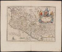
- Dutch text of verso, with caption title "Nieuvv Spanien" and signature 2G., From Jansson's Nieuwen atlas ... Amstelodami : Apud Ioannem Ianssonium, 1647., Includes ill., index, and text., and Relief shown pictorially.
- Publisher:
- Jan Jansson?,
- Subject (Geographic):
- Mexico--Maps--Early works to 1800
- Subject (Name):
- Jansson, Jan, 1588-1664. Atlas novus. Dutch
- Found in:
- Beinecke Rare Book and Manuscript Library > Nova Hispania et Nova Galicia.
- Creator:
- Roggeveen, Arent, -1679
- Published / Created:
- 1675?]
- Call Number:
- 73 1675
- Container / Volume:
- BRBL_00688
- Image Count:
- 1
- Resource Type:
- Maps, Atlases & Globes
- Description:
- From Roggeveen's Brandende veen ... Amsterdam : P. Goos ..., 1675. and Ms. no. on verso: 33. Sheet measures 51.5 x 62.6 cm. Cross Collection no. 164.
- Publisher:
- Pieter Goos?,
- Subject (Geographic):
- Atlantic Provinces--Maps--Early works to 1800 and Saint Lawrence, Gulf of--Maps--Early works to 1800
- Subject (Name):
- Goos, Pieter, approximately 1616-1675 and Roggeveen, Arent, -1679. Brandende veen
- Found in:
- Beinecke Rare Book and Manuscript Library > Pascaerte van Terra Nova, Nova Francia, Nieuw Engeland [cartographic material] / en de Groote Revier van Canada.