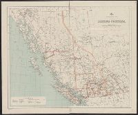
"Rand, McNally & Co.'s New Business Atlas Map of British Columbia.", Includes inset map: Northern part of British Columbia., and Index to railways overprinted in red in lower right; index to cities by population in left margin.
"Corrected to February 1st, 1908.", Indicates "lands disposed of, also timber berths.", Inset: Vancouver Island (Scale [ca. 1:1,267,200])., and Relief shown by spot heights.
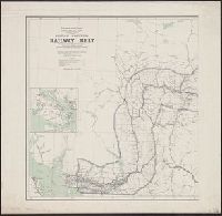
All maps west of the 5th & 7th meridians., Donald sheet -- Sicamous sheet -- Kamloops to Lytton sheet -- Port Moody to Yale sheet., and Relief shown by hachures and spot heights.
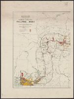
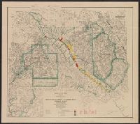
"669"--Lower right margin., Covers an area in southeastern British Columbia. Most of the area covered is in the Regional District of North Okanagan; the area includes Adams Lak, and Relief shown by contours, shading, and spot heights. Depths shown by soundings.
Publisher:
Geological Survey of Canada,
Subject (Geographic):
Shuswap Lake Region (B.C.)--Maps
Subject (Name):
Geological Survey of Canada and McEvoy, James, b. 1862
Subject (Topic):
Geology, Economic--British Columbia--Shuswap Lake Region--Maps, Glacial landforms--British Columbia--Shuswap Lake Region--Maps, and Mines and mineral resources--British Columbia--Shuswap Lake Region--Maps