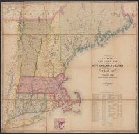
Telegraph and rail road map of the New England states, eastern portion of New York state and Canada
Description:
Entered according to act of Congress, in the year 1852, by Redding & Co. in the clerk's office of the District court of the United States for the district of Massachusetts. and Includes table showing the "cost of construction and equipment of all the rail roa
Eastern Virginia showing the positions of the armies on March 15, 1862., Field of Bull Run showing the positions of the armies at 4:30 p.m. on August 29, 1862., and Field of Fredericksburg showing the positions of the troops on the morning of December 13, 1862.
Description:
Annotated in red and blue to show Union and Confederate positions., Eastern Virginia showing the positions of the armies on March 15, 1862 [Scale ca. 1:1,005,840] --, and Kentucky and Tennessee showing the positions of the armies on the morning of February, 6,
Publisher:
s.n,
Subject (Geographic):
United States--History--Civil War, 1861-1865--Maps
Subject (Name):
Ropes, John Codman, 1836-1899. Story of the Civil War