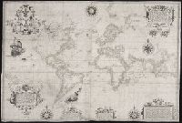
Guessefeld, F. L. (Franz Ludwig), 1744-1807 Harenberg, Johann Christoph, 1696-1774 Hase, Johann Matthias, 1684-1742 Homann Erben (Firm) Homann, Johann Baptist, 1663-1724 Lopez, D. T. Mayer, Tobias, 1723-1762 Rizzi-Zannoni, Giovanni Antonio, 1736-1814 Sperges, Joseph, Freiherr von, 1725-1791
Published / Created:
[1710-1786]
Call Number:
1983 Folio 23
Image Count:
2
Abstract:
A collection of maps issued by the Johann Baptist Homann or the Homann Erben firm between 1710 and 1786, made by various cartographers besides the Homann and the Homann Erben firm.
Certaine errors in nauigation / detected and corrected by Edw. Wright ; with many additions that
Image Count:
1
Description:
2d state, "William Kip sculpsit"., Formerly bound in Taylor 251., Housed and classed separately as BrSides Folio 2008 14., In pencil on verso: Beinecke / Library / Broadsides / Folio / 2008 / 14., Map has some small tears along previously folded edges that have been repaired., On verso: Yale proprietary stamp in center., and Scale not given.
Subject (Topic):
Nautical astronomy --Early works to 1800, Navigation --Early works to 1800, and Pilot guides --England --Early works to 1800
Collection Created:
[London] : Printed by Felix Kingsto[n] at London, 1610
Des Barres, Joseph F. W. (Joseph Frederick Wallet), 1722-1824
Published / Created:
1775?-1781?]
Call Number:
1983 Folio 25
Image Count:
3
Resource Type:
Maps, Atlases & Globes
Abstract:
A made-up collection of charts, plans and views, partly hand colored, from the Atlantic Neptune comprising [v. 1]: the charts of the South East Coast of Nova Scotia, with the title page of The charts of the coast and harbors of New England, 1781 bound in front (31 items, dated between 1777 and 1781). [v. 2]: Charts of the coast and harbours in the Gulph and river of St. Lawrence, 1780, including the charts of the coast of New England (36 items, dated between 1775 and 1781). [v. 3]: Charts of several harbours and divers parts of the coast of North America from New York south westwards to the Gulph of Mexico, 1780, including some 16 charts belonging to the New England part of the work (35 items, dated between 1776 and 1781). General title page wanting.
Description:
Includes indexes.
Publisher:
The Admiralty,
Subject (Geographic):
North America--Maps and North America--Pictorial works