Search
You Searched For
Search Results
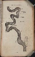
- Call Number:
- Zc20 802crc
- Collection Title:
- The navigator; or, The traders' useful guide in navigating the Monongahela, Allegheny, Ohio, and
- Image Count:
- 1
- Description:
- P. 55.
- Subject (Geographic):
- Chickasaw Bluffs (Tenn.), Mississippi River --Description and travel, Mississippi River --Maps, Mississippi River --Navigation, and Tennessee
- Collection Created:
- Pittsburgh, From the Press of Zadok Cramer, 1806
- Found in:
- Beinecke Rare Book and Manuscript Library > [A portion of the Mississippi River, including Chickasaw Bluffs]
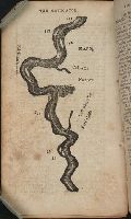
- Call Number:
- Zc20 802crc
- Collection Title:
- The navigator; or, The traders' useful guide in navigating the Monongahela, Allegheny, Ohio, and
- Image Count:
- 1
- Description:
- P. 72.
- Subject (Geographic):
- Mississippi, Mississippi River --Description and travel, Mississippi River --Maps, Mississippi River --Navigation, and Natchez (Miss.)
- Collection Created:
- Pittsburgh, From the Press of Zadok Cramer, 1806
- Found in:
- Beinecke Rare Book and Manuscript Library > [A portion of the Mississippi River, including Natchez]
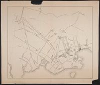
- Call Number:
- 766 N46 1917
- Container / Volume:
- BRBL_00473A
- Image Count:
- 15
- Resource Type:
- Maps, Atlases & Globes
- Description:
- Blueprint
- Subject (Geographic):
- New Haven (Conn)--Maps
- Found in:
- Beinecke Rare Book and Manuscript Library > [City of New Haven] 1913-1917.
- Call Number:
- 771hc B796 1776A
- Container / Volume:
- BRBL_00495
- Image Count:
- 1
- Resource Type:
- Maps, Atlases & Globes
- Subject (Geographic):
- Brooklyn (New York, N.Y.)--Maps--Early works to 1800
- Found in:
- Beinecke Rare Book and Manuscript Library > [Map of Brooklyn, N.Y., showing the battle in this area in 1776, superimposed upon a modern street map.]
- Creator:
- Rogers, William, b. ca. 1545, engraver
- Published / Created:
- Undated
- Call Number:
- Taylor 216A
- Collection Title:
- Iohn Huighen van Linschoten, his Discours of Voyages into ye Easte & West Indies : deuided into
- Image Count:
- 1
- Description:
- Bound in following title page of second book. and Map has small tear at bottom fold in center.
- Subject (Geographic):
- Africa --Maps --Early works to 1800, Cape of Good Hope --Maps, Congo (Democratic Republic) --Maps, and Madagascar --Maps --Early works to 1800
- Subject (Name):
- Wolfe, John, d. 1601, printer
- Subject (Topic):
- Voyages and travels --Early works to 1800
- Collection Created:
- [London] : Printed at London by [John Windet for] Iohn Wolfe, printer to ye Honorable Cittie of London, [1598]
- Found in:
- Beinecke Rare Book and Manuscript Library > [Map of southern Africa and Madagascar]
- Call Number:
- 11ba 1915
- Container / Volume:
- BRBL_00010A
- Image Count:
- 1
- Resource Type:
- Maps, Atlases & Globes
- Description:
- Sectional globe, showing steamship routes and transcontinental railways.
- Publisher:
- London Geographical Institute
- Subject (Geographic):
- World--maps
- Found in:
- Beinecke Rare Book and Manuscript Library > [Philips' 12 inch terrestrial globe.]
- Call Number:
- Lxe 784m
- Collection Title:
- Geography made easy : being a short, but comprehensive system of that very useful and agreeable
- Image Count:
- 1
- Resource Type:
- Books, Journals & Pamphlets
- Description:
- Imperfect: engraving of map not completed.
- Subject (Name):
- Doolittle, Amos, 1754-1832
- Subject (Topic):
- Geography
- Collection Created:
- New Haven : Meigs, Bowen & Dana, [1784]
- Found in:
- Beinecke Rare Book and Manuscript Library > [Placement of the divisions of South America]
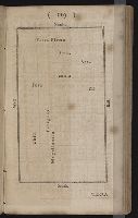
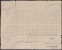
- Call Number:
- 771 OS9 1836
- Container / Volume:
- BRBL_00490
- Image Count:
- 1
- Resource Type:
- Maps, Atlases & Globes
- Description:
- Inset: The vicinity of Oswego Falls and Preliminary record.
- Publisher:
- P.A. Messier's, Lith.
- Subject (Geographic):
- Oswego County (N.Y.)--Maps
- Found in:
- Beinecke Rare Book and Manuscript Library > map of the Village of Oswego Falls to be Sold on hte Premises by Jas. Bleecker & Sons on the 18th October 1836.
- Call Number:
- 783 1673D
- Container / Volume:
- BRBL_00507
- Image Count:
- 1
- Resource Type:
- Maps, Atlases & Globes
- Description:
- Facsimile.
- Subject (Geographic):
- Virginia--Maps--Early works to 1800
- Found in:
- Beinecke Rare Book and Manuscript Library > virginia and Maryland. As it is planted and inhabited this present year 1670. Surveyed and Exactly Drawne by ... Augustin Herrman, 1673.