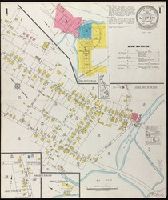
Fire insurance map, colored to show building construction, property boundaries and house and block numbers.
Alternative Title:
July 1923, Milton, Del. and Milton, Del.
Description:
"1131 (3 sheets).", Coordinates not present on map and are approximated., Index map at scale of 600 feet to 1 inch, or 1:7,200., Maps on sheets 1 and 3 are at a scale of 1:1200, map on sheet 2 is at a scale of 1:600., Partial cadastral map., and Sheet 1 includes key to building colors and other features of construction, water facilities and fire department, index map for the adjoining sheets, and information about updates.
Publisher:
Sanborn Map Company,
Subject (Geographic):
Milton (Del.)--Maps.
Subject (Topic):
Fire risk assessment--Delaware--Milton--Maps. and Real property--Delaware--Milton--Maps.
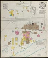
"Reproduction verified by the Coast and Geodetic Survey, April 1911.", Cadastral map., Facsimile., and Shows city blocks, Texas and Pacific railroad reserve, Texas and Santa Fe railroad reserve, and Rio Grande.
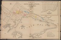
"Approved and declared to be the official map of Kern County, May 7th, 1898.", Relief shown by shading and spot heights., and Shows drainage, township and section lines, land ownership, ranchos, supervisor districts, railroads, etc.
Publisher:
W.B. Walkup,
Subject (Geographic):
Kern County (Calif.)--Administrative and political divisions--Maps and Kern County (Calif.)--Maps
Subject (Name):
W.B. Walkup & Co
Subject (Topic):
Land grants--California--Kern County--Maps and Real property--California--Kern County--Maps
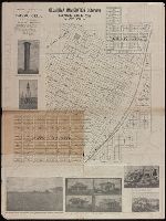
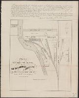
"Compiled for and copyrighted by Nicholas G. Morgan, Sr.", "This drawing ... is a copy of an undated Pioneer Map, drawn (apparently) in the late 1850s.", Blue line print., and Includes text, real estate block numbers, names of tract owners, and index of owners.
Subject (Name):
Morgan, Nicholas G. (Nicholas Groesbeck), 1884-1971
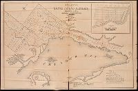
Coordinates not present on map and are approximated., Imperfect: mutilated, with some loss of text. Manuscript annotations on map. Manuscript title on verso: Thunder Bay Silver Mining District. From the Richard H. Rickard Papers., Inset: plan of town plot, Fort William., and Relief shown by hachures.
Publisher:
[publisher not identified],
Subject (Name):
Copp Clark Company and Rickard, Richard H.,---1885--Ownership.
Subject (Topic):
Real property--Ontario--Thunder Bay Region--Maps. and Silver mines and mining--Ontario--Thunder Bay Region--Maps.
Coordinates not present on map and are approximated., Imperfect. Mutilated with loss of text., Inset: plan of town plot, Fort William., and Relief shown by hachures.
Publisher:
[publisher not identified],
Subject (Name):
Copp Clark Company and Rickard, Richard H.,---1885--Ownership.
Subject (Topic):
Real property--Ontario--Thunder Bay Region--Maps. and Silver mines and mining--Ontario--Thunder Bay Region--Maps.