Bar scales in Milliaria Germanica Communia and Milliaria Gallica Communia., Ferro meridian., No. 37 of 69 maps bound together in composite atlas., Relief shown pictorially., and Scale [ca. 1:775 000].
Publisher:
[Frederik de Wit]
Subject (Geographic):
Prussia, east (Poland and Russia) --Maps --Early works to 1800
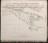
Maps of the Orinoco-Essequibo region, South America. Compiled for the Commission appointed by the
Image Count:
1
Resource Type:
Maps, Atlases & Globes
Subject (Geographic):
Amazon River--Discovery and exploration--Spanish, Amazon River--Maps, Caribbean Area--Maps--Early works to 1800, Colombia --Maps, Guyana --Maps, Orinoco River Valley (Venezuela and Colombia) --Maps, and Venezuela --Maps
Sanborn fire insurance maps are a rich source of historic data on the urban built environment of North America during the 19th and early 20th centuries. The atlases were created for the purpose of underwriting fire insurance policies, which depended upon accurate and frequently-updated information about construction materials, municipal and transportation infrastructure, industrial and commercial landuse and more. The Yale University Library Map Department scanned its holdings of Sanborn fire insurance maps (consisting primarily of Connecticut towns) in order to make the maps more accessible.
Alternative Title:
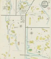
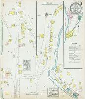
Aug. 1895, East Haddam, Conn.
Description:
"2 sheets. 8115.", Contains information on population, prevailing winds, water facilities and fire department., Partial cadastral map., and SMLMAPL 766 Ea73 1895: Sheets disbound. "Triplicate" stamp on both sheets. Library of Congress copyright stamp on title sheet.
Subject (Geographic):
East Haddam (Conn. : Town)--Maps
Subject (Name):
Library of Congress Stamp
Subject (Topic):
Fire risk assessment--Connecticut--East Haddam (Town)--Maps and Real property--Connecticut--East Haddam (Town)--Maps
Sanborn fire insurance maps are a rich source of historic data on the urban built environment of North America during the 19th and early 20th centuries. The atlases were created for the purpose of underwriting fire insurance policies, which depended upon accurate and frequently-updated information about construction materials, municipal and transportation infrastructure, industrial and commercial landuse and more. The Yale University Library Map Department scanned its holdings of Sanborn fire insurance maps (consisting primarily of Connecticut towns) in order to make the maps more accessible.
Alternative Title:
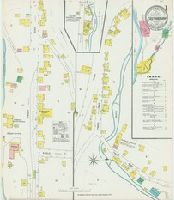
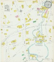
Oct. 1903, E. Haddam and Moodus, Conn.
Description:
"3 sheets. 6537.", "Including Moodus.", Contains information on population, prevailing winds, water facilities and fire department., Includes index of specials., Partial cadastral map., and SMLMAPL 766 Ea73 1903: Sheets disbound. "Triplicate" stamp on first 2 sheets. Library of Congress copyright stamp on title sheet.
Subject (Geographic):
East Haddam (Conn. : Town)--Maps
Subject (Name):
Library of Congress Stamp
Subject (Topic):
Fire risk assessment--Connecticut--East Haddam (Town)--Maps and Real property--Connecticut--East Haddam (Town)--Maps
Sanborn fire insurance maps are a rich source of historic data on the urban built environment of North America during the 19th and early 20th centuries. The atlases were created for the purpose of underwriting fire insurance policies, which depended upon accurate and frequently-updated information about construction materials, municipal and transportation infrastructure, industrial and commercial landuse and more. The Yale University Library Map Department scanned its holdings of Sanborn fire insurance maps (consisting primarily of Connecticut towns) in order to make the maps more accessible.
Alternative Title:
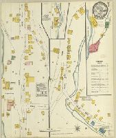
Aug. 1908, E. Haddam and Moodus, Conn.
Description:
"3 sheets. 534.", "Including Moodus.", Contains information on population, prevailing winds, water facilities and fire department., Includes index of specials., Partial cadastral map., and SMLMAPL 766 Ea73 1908: Sheets disbound. "Triplicate" stamp on all sheets. Library of Congress copyright stamp on title sheet.
Subject (Geographic):
East Haddam (Conn. : Town)--Maps
Subject (Name):
Library of Congress Stamp
Subject (Topic):
Fire risk assessment--Connecticut--East Haddam (Town)--Maps and Real property--Connecticut--East Haddam (Town)--Maps
Sanborn fire insurance maps are a rich source of historic data on the urban built environment of North America during the 19th and early 20th centuries. The atlases were created for the purpose of underwriting fire insurance policies, which depended upon accurate and frequently-updated information about construction materials, municipal and transportation infrastructure, industrial and commercial landuse and more. The Yale University Library Map Department scanned its holdings of Sanborn fire insurance maps (consisting primarily of Connecticut towns) in order to make the maps more accessible.
Alternative Title:
Apr. 1925, East Haddam, Conn.
Description:
"(2122). (3 sheets).", Contains information on population, prevailing winds, water facilities and fire department., Includes index of specials., Partial cadastral map., and SMLMAPL 766 Ea73 1925: Sheets disbound. Library of Congress copyright stamp on title sheet.
Subject (Geographic):
East Haddam (Conn. : Town)--Maps
Subject (Name):
Library of Congress Stamp
Subject (Topic):
Fire risk assessment--Connecticut--East Haddam (Town)--Maps and Real property--Connecticut--East Haddam (Town)--Maps
Sanborn fire insurance maps are a rich source of historic data on the urban built environment of North America during the 19th and early 20th centuries. The atlases were created for the purpose of underwriting fire insurance policies, which depended upon accurate and frequently-updated information about construction materials, municipal and transportation infrastructure, industrial and commercial landuse and more. The Yale University Library Map Department scanned its holdings of Sanborn fire insurance maps (consisting primarily of Connecticut towns) in order to make the maps more accessible.
Alternative Title:
Moodus, Conn., Part of E. Haddam Township
Description:
"(2 sheets).", "Including Moodus.", Contains information on population, prevailing winds, water facilities and fire department., Includes index of specials., Partial cadastral map., and SMLMAPL 766 Ea73 1935: Sheets disbound. Library of Congress copyright stamp on title sheet.
Subject (Geographic):
East Haddam (Conn. : Town)--Maps
Subject (Name):
Library of Congress Stamp
Subject (Topic):
Fire risk assessment--Connecticut--East Haddam (Town)--Maps and Real property--Connecticut--East Haddam (Town)--Maps
Sanborn fire insurance maps are a rich source of historic data on the urban built environment of North America during the 19th and early 20th centuries. The atlases were created for the purpose of underwriting fire insurance policies, which depended upon accurate and frequently-updated information about construction materials, municipal and transportation infrastructure, industrial and commercial landuse and more. The Yale University Library Map Department scanned its holdings of Sanborn fire insurance maps (consisting primarily of Connecticut towns) in order to make the maps more accessible.
Alternative Title:
Dec. 1903, East Hampton, Conn.
Description:
"6662. 2 sheets.", Contains information on population, prevailing winds, water facilities and fire department., Partial cadastral map., and SMLMAPL 766 Ea74 1903: Sheets disbound. "Triplicate" stamp on both sheets. Library of Congress copyright stamp on title sheet.
Subject (Geographic):
East Hampton (Conn. : Town)--Maps
Subject (Name):
Library of Congress Stamp
Subject (Topic):
Fire risk assessment--Connecticut--East Hampton (Town)--Maps and Real property--Connecticut--East Hampton (Town)--Maps
Sanborn fire insurance maps are a rich source of historic data on the urban built environment of North America during the 19th and early 20th centuries. The atlases were created for the purpose of underwriting fire insurance policies, which depended upon accurate and frequently-updated information about construction materials, municipal and transportation infrastructure, industrial and commercial landuse and more. The Yale University Library Map Department scanned its holdings of Sanborn fire insurance maps (consisting primarily of Connecticut towns) in order to make the maps more accessible.
Alternative Title:
Aug. 1908, East Hampton, Conn.
Description:
"2 sheets. #539.", Contains information on population, prevailing winds, water facilities and fire department., Partial cadastral map., and SMLMAPL 766 Ea74 1908: Sheets disbound. "Triplicate" stamp on both sheets. Library of Congress copyright and Map Division stamps on title sheet.
Subject (Geographic):
East Hampton (Conn. : Town)--Maps
Subject (Name):
Library of Congress Stamp and Library of Congress. Map Division Stamp
Subject (Topic):
Fire risk assessment--Connecticut--East Hampton (Town)--Maps and Real property--Connecticut--East Hampton (Town)--Maps