Browne, Christopher, fl. 1684-1712 Fer, Nicolas de, 1646-1720, creator
Published / Created:
[1704?]
Call Number:
1973 Folio 10
Image Count:
1
Resource Type:
Maps, Atlases & Globes
Alternative Title:
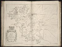
New map of the theatre of the war in Flanders and on the Rhine and Theatre of the warr in Flanders
Description:
Bar scales given in English miles., Dedicated to Q. Anne by C. Browne., Ferro meridian., Includes inset map the Rhine River Valley., No. 46 of 69 maps bound together in composite atlas., Relief shown pictorially., and Scale [ca. 1:600 000].
Publisher:
Made english and sold by C. Browne at the Globe at the west end of St. Pauls Church
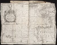
Certaine errors in nauigation / detected and corrected by Edw. Wright ; with many additions that
Image Count:
1
Description:
[ca. 1:5,400,000]., Bound in following p. 110., Linear brown stain at top on verso., Middle panel right of center has small hole., and Several small yellow, brown and black stains can be seen on both the recto and verso.
Subject (Geographic):
Azores
Subject (Topic):
Cosmography--Early works to 1800, Nautical astronomy --Early works to 1800, and Navigation --Early works to 1800
Collection Created:
[London] : Printed by Felix Kingsto[n] at London, 1610
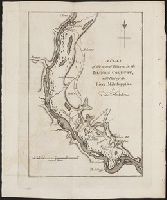
A topographical description of the Western territory of North America; containing a succinct
Image Count:
1
Description:
Engrav'd for S. Campbell's Edition of Imlay's Description of Kentucky., Facing p. 111., and Teaching resource: Professor John Mack Faragher, History 141: The American West.
Subject (Geographic):
Genesee River Valley (Pa. and N.Y.) --Early works to 1800, Mississippi River Valley --Description and travel --Early works to 1800, Mississippi River Valley --History --To 1803, and Ohio River Valley --Description and travel -
Subject (Name):
Filson, John, ca. 1747-1788 Discovery, settlement, and present state of Kentucky, Toulmin, Harry, 1766-1823 Thoughts on emigration, and United States. Dept. of State
Subject (Topic):
Public lands --United States --Early works to 1800
Collection Created:
New-York, Printed by Samuel Campbell, No. 37, Hanover Square, M,DCC,XCIII
A topographical description of Virginia, Pennsylvania, Maryland and North Carolina : comprehending
Image Count:
1
Description:
Between p. 40 and 41. and Teaching resource: Professor John Mack Faragher, History 141: The American West.
Subject (Geographic):
Illinois River (Ark. and Okla.) --Early works to 1800, Mississippi River Valley --Description and travel --Early works to 1800, and Ohio River Valley --Description and travel --Early works to 1800
Subject (Topic):
Indians of North America --Statistics --Early works to 1800
Collection Created:
London : Printed for the author, and sold by J. Almon, opposite Burlington House, in Piccadilly, M DCC LXXVIII [1778]