"For the Lond. Mag.", From the London Magazine (August 1757), p. 376., and Sheet measures 20.5 x 26.4 cm. Cross Collection no. 206.
Publisher:
Printed for R. Baldwin in Pater Noster Row,
Subject (Geographic):
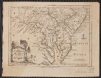
Chesapeake Bay Region (Md. and Va.)--Maps--Early works to 1800, Delaware--Maps--Early works to 1800, New Jersey--Maps--Early works to 1800, and Pennsylvania--Maps--Early works to 1800
Includes eastern Connecticut ; Massachusetts as far north as Boston, including Cape Cod, Martha's Vineyard, and Nantucket ; and the eastern end of Long Island.
Alternative Title:
Colony of Rhode Island and Rhode Island
Description:
"London Magazine 1778"--Top margin., From The London Magazine (November 1778)., Publisher from bottom margin., Relief shown pictorially., and Sheet measures 21 x 28.4 cm. Inscription on verso: William Akers. Cross Collection no. 198.
Publisher:
Printed for R. Baldwin at the Rose, Pater Noster Row,
Subject (Geographic):
New England--Maps--Early works to 1800
Subject (Name):
Akers, William--Autograph and Baldwin, R. (Robert), 1737-1810
From George Henry Millar's New complete & universal system of geography. 1782., Inset map: "East Florida continued"., Recto: Numbered "166" (?) in ink ms. Verso: Stamped "Yale Horace Brown 1900S"., and Relief shown pictorially.
Publisher:
Engrav'd for Millar's New complete & universal system of geography,
[Peter Force map collection ; 356] and Map of North America (1787)
Description:
"Longitude west from London.", Relief shown pictorially., and Yale's copy folded in covers 41 x 29 cm. with label titled "Map of North America (1787)"; presented by Rev. Kenneth Walter Cameron to Yale, accompanied by 1927 letter.
Publisher:
Engraved for Jno. Harrison No. 115 Newgate Street,