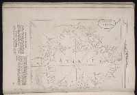
The English pilot: describing the West-India navigation, from Hudson's-Bay to the river Amazones
Image Count:
1
Subject (Geographic):
Atlantic Ocean --Maps --Early works to 1800, Boston (Mass.) --Maps --Early works to 1800, Boston Harbor (Mass.) --Maps --Early works to 1800, New England --Maps --Early works to 1800, and New York (State) --Maps --Early works to 1800
Subject (Topic):
Navigation --Early works to 1800, Pilot guides --Atlantic Coast (U.S.) --Early works to 1800, and Pilot guides --Caribbean Area --Early works to 1800
Collection Created:
London : Printed for Thomas Page, William and Fisher Mount, in Postern-Row on Tower-hill, MDCCXXV [1725]
Also appeared in Faden's [General atlas. London : William Faden, 1811?]., Imperfect: torn along fold, with no loss of text., No. 31 of 43 maps bound together in composite atlas., Relief shown pictorially., Scale [ca. 1:480,000]., and Sheets pasted together to form 1 sheet.
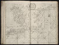
Forty-two new maps of Asia, Africa, and America ... : all engrav’d, according to the latest
Image Count:
1
Alternative Title:
Chili, Patagonia, part of La Plata &c
Description:
In pencil on verso: 27. and Table of contents for maps 2-20 in section "America" misnumbered.
Subject (Geographic):
Chile --Maps --Early works to 1800, Patagonia (Argentina and Chile) --Maps --Early works to 1800, South America --Maps --Early works to 1800, and Tierra del Fuego (Argentina and Chile)
Forty-two new maps of Asia, Africa, and America ... : all engrav’d, according to the latest
Image Count:
1
Alternative Title:
Mexico, or New Spain
Description:
In pencil on verso: 33. and Table of contents for maps 2-20 in section "America" misnumbered.
Subject (Geographic):
California --Maps --Early works to 1800, Central America --Maps --Early works to 1800, Florida --Maps --Early works to 1800, Louisiana --Maps --Early works to 1800, Mexico --Maps --Early works to 1800, and New Mexico --Maps