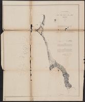
Peirce, Benjamin, 1809-1880 United States Coast Survey
Published / Created:
1869
Call Number:
846cea Or4 1869
Container / Volume:
BRBL_00623
Image Count:
1
Resource Type:
Maps, Atlases & Globes
Description:
In upper left margin: No. 16., Includes notes., Relief shown by hachures. Depths shown by soundings., and Removed from: United States Coast Survey, Annual report of the superintendent of the Coast Survey (1869).
Publisher:
U.S. Coast Survey,
Subject (Geographic):
Blanco, Cape (Or.)--Maps and Port Orford (Or.)--Maps
Subject (Name):
United States Coast Survey. Annual report of the superintendent of the Coast Survey. 1869
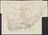
"London, pubd. 15 Feby. 1840 by J. Arrowsmith, 10 Soho Square.", "This map is by permission copied from the original ms. drawing in the Colonial Office, compiled by Mr. Hebert, Senr.", In lower right margin: 24., and Relief shown by hachures.
Publisher:
J. Arrowsmith,
Subject (Geographic):
Cape of Good Hope (South Africa)--Maps and South Africa--Maps
Eight engravings (some after John Webber) bordering a large sheet. and With manuscript poem titled "Idleness and sloth" signed by John Rodda and dated December 20th, 1815.
Publisher:
Printed & published by Edwd. Langley,
Subject (Name):
Cook, James,--1728-1779, Langley, Edward, active 1791-1835, and Rodda, John
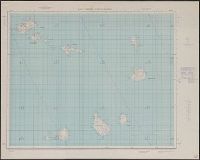
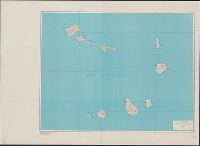
Germany. Heer. Abteilung für Kriegskarten- und Vermessungswesen II
Published / Created:
1941
Call Number:
329 C17 1941
Container / Volume:
BRBL_00074
Image Count:
3
Resource Type:
Maps, Atlases & Globes
Alternative Title:
England 1:10 000 ; GB 7, BB 32a, 32b, 32c and Stadtplan von Cardiff mit Mil.-Geo.-Eintragungen
Description:
"Militärgeogr. Angaben nach den bis zum 30. XI. 1941 vorhandenen Unterlagen.", Relief shown by hachures and spot heights., and Shows features of military interest.
Publisher:
Generalstab des Heeres, Abteilung für Kriegskarten- u. Vermessungswesen (II),