Skip to search
Skip to main content
Skip to first result
Search
You Searched For
Access
Public
Genre
Maps
New Search
Search Results
Creator:
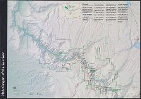
Published / Created:
c1975.
Call Number:
832 B574 1975
Container / Volume:
BRBL_00582
Image Count:
1
Resource Type:
Maps, Atlases & Globes
Alternative Title:
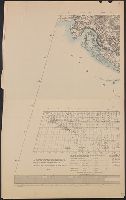
Big sky maps
Description:
Includes index map and indexes to "Road names" and "Landmarks.", Relief shown by hachures and spot heights., and Shows section lines, township, and ranges.
Publisher:
K.D.B. Enterprises,
Subject (Geographic):
Blaine County (Idaho)--Maps
Found in:
Beinecke Rare Book and Manuscript Library > Blaine County, Idaho.
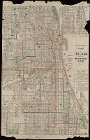
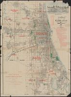
Published / Created:
1906
Call Number:
806 C43 1906
Container / Volume:
BRBL_00548
Image Count:
2
Resource Type:
Maps, Atlases & Globes
Alternative Title:
Blanchard's map of Chicago
Description:
Imperfect: Mutilated with loss of text: Ms. notations in blue. and Shows railroad and street railway lines.
Publisher:
Rufus Blanchard,
Subject (Geographic):
Chicago (Illinois)--Maps
Found in:
Beinecke Rare Book and Manuscript Library > Blanchard's map of Chicago : with the new street names.
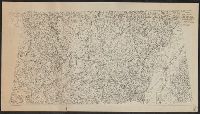
Creator:
Published / Created:
1918
Call Number:
44cbd 1918
Container / Volume:
BRBL_00256
Image Count:
4
Resource Type:
Maps, Atlases & Globes
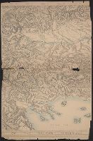
Description:
"Topography is based particularly upon the Generalkarte von Mitteleuropa of the Austrian General Staff (Scale 1:300,000).", In addition to landforms, shows bodies of water, transportation infrastructure, towns, and cities., and Lists maps on which map is based.
Publisher:
The American Geographical Society,
Subject (Geographic):
Balkan Peninsula--Maps
Subject (Topic):
Slopes (Physical geography)--Balkan Peninsula--Maps
Found in:
Beinecke Rare Book and Manuscript Library > Block diagram showing terrain of the Balkan Peninsula [cartographic material].
Creator:
Published / Created:
[1918]
Call Number:
11hcf 1919C-2
Container / Volume:
BRBL_00010T
Image Count:
2
Resource Type:
Maps, Atlases & Globes
Description:
Relief shown by shading and spot heights.
Publisher:
The American Geographical Society,
Subject (Geographic):
Balkan Peninsula--Maps
Subject (Topic):
Slopes (Physical geography)--Balkan Peninsula--Maps
Found in:
Beinecke Rare Book and Manuscript Library > Block diagram showing terrain of the Balkan Peninsula.
Branch:v1.61.6 ,Deployed:2024-06-12T09:55:36-04:00