Skip to search
Skip to main content
Skip to first result
Search
You Searched For
Access
Public
Genre
Maps
New Search
Search Results
Creator:
Published / Created:
1943
Call Number:
409 C17 1943
Container / Volume:
BRBL_00240
Image Count:
1
Resource Type:
Maps, Atlases & Globes
Alternative Title:
Geographical Section, General Staff ; no. 4378, GSGS (Series) ; 4378., and Sardinia
Description:
"8-43.", "Form lines from air photographs at intervals of 20 metres.", "From C.I.U. plan of March 1943.", and Military grid.
Publisher:
Army Map Service, U.S. Army,
Subject (Geographic):
Carbonia (Italy)--Maps
Subject (Name):
United States. Army Map Service
Found in:
Beinecke Rare Book and Manuscript Library > Carbonia [cartographic material] / photolithographed by War Office, 1943.
Creator:
Published / Created:
1941
Call Number:
329 C17 1941
Container / Volume:
BRBL_00074
Image Count:
3
Resource Type:
Maps, Atlases & Globes
Alternative Title:
England 1:10 000 ; GB 7, BB 32a, 32b, 32c and Stadtplan von Cardiff mit Mil.-Geo.-Eintragungen
Description:
"Militärgeogr. Angaben nach den bis zum 30. XI. 1941 vorhandenen Unterlagen.", Relief shown by hachures and spot heights., and Shows features of military interest.
Publisher:
Generalstab des Heeres, Abteilung für Kriegskarten- u. Vermessungswesen (II),
Subject (Geographic):
Cardiff (Wales)--Maps
Found in:
Beinecke Rare Book and Manuscript Library > Cardiff.
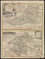
Published / Created:
1754
Call Number:
3297 1754
Container / Volume:
BRBL_00074
Image Count:
1
Resource Type:
Maps, Atlases & Globes
Description:
Inset: Pembroke Shire ca. 1:210,000. and Preliminary record.
Subject (Geographic):
Cardiganshire (Wales)--Maps--Early works to 1800
Found in:
Beinecke Rare Book and Manuscript Library > Cardigan Shire ... T. Kitchin ...
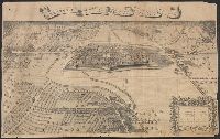
Creator:
Published / Created:
November 1944.
Call Number:
289 C19 1944
Container / Volume:
BRBL_00027
Image Count:
1
Resource Type:
Maps, Atlases & Globes
Description:
"Sheet 1 of 4 sheets".
Publisher:
Office of the Chief Engineer, Engineer Intelligence Section,
Subject (Geographic):
Leyte Island (Philippines)--Maps
Found in:
Beinecke Rare Book and Manuscript Library > Carigara (Leyte Island) [cartographic material].
Published / Created:
[1680?]
Call Number:
41 1680
Container / Volume:
BRBL_00241
Image Count:
2
Resource Type:
Maps, Atlases & Globes
Alternative Title:
Carinthiae dvcatvs, et Goritiae palatinatvs, Histriæ tabula à Petro Cappo ..., and Zarae, et Sebenici descriptio
Subject (Geographic):
Austria--Maps--Early works to 1800 and Hungary--Maps--Early works to 1800
Found in:
Beinecke Rare Book and Manuscript Library > Carinthiae ducatus, et Goritiae palatinatus / Wolf. Lazio auctore.
Published / Created:
[1903?]
Call Number:
615 1903
Container / Volume:
BRBL_00332
Image Count:
1
Resource Type:
Maps, Atlases & Globes
Alternative Title:
Die Nil-Länder and Nil-Länder
Description:
"IX.03.", In German., and Inset maps: [1.] Massaua. Verhältniss 1:80 000 -- [2.] Massaua und Umgegend. Verhältniss 1:1 000 000.
Publisher:
Carl Fleming, Verlag, Buch- und Kunstdruckerei, A.G.,
Subject (Geographic):
Africa, Northeast--Maps
Found in:
Beinecke Rare Book and Manuscript Library > Carl Flemings Generalkarten. No. 47. Die Nil-Länder / bearbeitet und ergänzt im kartographischen Institut der Verlagsbuchhandlung.
Published / Created:
1691
Call Number:
40AM C21 1691
Container / Volume:
BRBL_00227
Image Count:
1
Resource Type:
Maps, Atlases & Globes
Subject (Geographic):
Carmagnola (Italy)--Maps--Early works to 1800
Found in:
Beinecke Rare Book and Manuscript Library > Carmagnoli ingenomen in 1691. Prise en 1691 Door Syn Ht. Den Par S.A.S. le Pr. Eugenius Van Pr. Eugene de Savoye.
Published / Created:
1750?]
Call Number:
32992 1750
Container / Volume:
BRBL_00074
Image Count:
1
Resource Type:
Maps, Atlases & Globes
Description:
Inset: Glamorgan Shire ca. 1:210,000. and Preliminary record.
Subject (Geographic):
Carmarthenshire (Wales)--Maps--Early works to 1800
Found in:
Beinecke Rare Book and Manuscript Library > Carmarthen Shire ... Tho. Kitchin ...
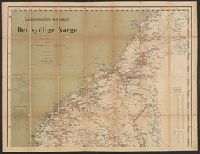
Published / Created:
1884
Call Number:
344 1884
Container / Volume:
BRBL_00093
Image Count:
2
Resource Type:
Maps, Atlases & Globes
Description:
List on margin of "Afstandstabeller for Jerbanerne". and Shows roads, railroads, etc.
Publisher:
Carnmermeyer,
Subject (Geographic):
Norway--Maps
Found in:
Beinecke Rare Book and Manuscript Library > Carnmermeyers Reisekart over det sydlige Norge Udarbeidet efter officielle Karter og Opgaren ved Per Nissen.
Call Number:
1976 1233
Collection Title:
Forty-two new maps of Asia, Africa, and America ... : all engrav’d, according to the latest
Image Count:
1
Alternative Title:
A map of ye island of Bermudos, divided into its tribes w.th the castles, forts &c and Carolina and Bermudos
Description:
In pencil on verso: 40. and Table of contents for maps 2-20 in section "America" misnumbered.
Subject (Geographic):
Bermuda Islands --Maps --Early works to 1800, North Carolina --Maps --Early works to 1800, and South Carolina --Maps --Early works to 1800
Subject (Name):
Nicholson, John, d. ca. 1717, bookseller
Subject (Topic):
Atlases --Early works to 1800
Collection Created:
London : Printed for J. Nicholson ..., 1716 ...
Found in:
Beinecke Rare Book and Manuscript Library > Carolina
Branch:v1.61.6 ,Deployed:2024-06-12T09:55:19-04:00