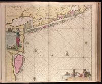
"Met prevelegie voor 15 Jaer"., Appeared in Gerard van Keulen's Nieuwe groote ligtende Zee-Fakkel ... 1734; cf. Koeman, C. Atlantes Neerlandici, IV, Keu 45, map 9., Backed with paper. Ms. no. "43" in upper right-hand corner. Sheet measures 53.7 x 62.9 cm. No. 41 of 87 maps bound together., Bar scales given in "Duytsche Mylen," "Spaensche Mylen," and "Eng. Fratn. Mylen"., Depths shown by soundings., and With north oriented towards the bottom.
Publisher:
By Ioannes van Keulen ...,
Subject (Geographic):
West Frisian Islands (Netherlands)--Maps--Early works to 1800.
Subject (Name):
Keulen, Gerard van. Nieuwe groote lichtende zee-fakkel.
Subject (Topic):
Nautical charts--Netherlands--West Frisian Islands--Early works to 1800.
"18" in lower right corner., "Met Previlegie voor 15 Iaar"., Appeared in Gerard van Keulen's Nieuwe groote ligtende Zee-Fakkel ... 1734; cf. Koeman, C. Atlantes Neerlandici, IV, Keu 45, map 30., Backed with paper. Ms. no. "14" in upper right-hand corner. Sheet measures 53.6 x 62.5 cm. No. 14 of 87 maps bound together., Includes four bar scales, Relief shown pictorially; depths shown by soundings., Watermark., and With north oriented towards the right.
Publisher:
By Johannes van Keulen ...,
Subject (Geographic):
Finland--Maps--Early works to 1800. and Sweden--Maps--Early works to 1800.
Subject (Name):
Keulen, Gerard van. Nieuwe groote lichtende zee-fakkel. and Vooght, Claes Janszoon, -1696.
Subject (Topic):
Nautical charts--Bothnia, Gulf of--Early works to 1800.
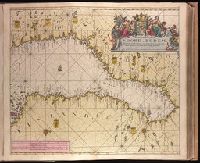
"28" in lower right corner., Appeard in Gerard van Keulen's Nieuwe groote ligtende Zee-Fakkel ... 1734; cf. Koeman, C. Atlantes Neerlandici, IV, Keu 45, map 56., Backed with paper. Ms. no. "6" in upper right-hand corner. Sheet measures 53.4 x 62.0 cm. No. 5 of 87 maps bound together., Bar scales given in "Duytsche Mylen," "Spaansche Mylen," and "Eng. en Fran. Mylen"., Includes smaller scale map of coast at top, "Paskaart van een Gedeelte van 't Liet van Bergen In 't Groot"., Relief shown pictorially., Watermark., and With north oriented towards the left.
Publisher:
By Iohannis van Keulen ...,
Subject (Geographic):
Hordaland fylke (Norway)--Maps--Early works to 1800.
Subject (Name):
Keulen, Gerard van. Nieuwe groote lichtende zee-fakkel.
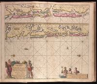
"30" in lower right corner., Appeard in Gerard van Keulen's Nieuwe groote ligtende Zee-Fakkel ... 1734; cf. Koeman, C. Atlantes Neerlandici, IV, Keu 45, map 58., Backed with paper. Ms. no. "7" in upper right-hand corner. Sheet measures 53.6 x 62.6 cm. No. 6 of 87 maps bound together., Bar scales given in "Duytsche Mylen," "Spaansche Mylen," and "Eng. en Fran. Mylen"., Relief shown pictorially., and With north oriented towards the bottom.
Publisher:
By Iohannis van Keulen ...,
Subject (Geographic):
Sør-Trøndelag (Norway)--Maps--Early works to 1800.
Subject (Name):
Keulen, Gerard van. Nieuwe groote lichtende zee-fakkel.
Subject (Topic):
Coasts--Norway--Maps--Early works to 1800. and Nautical charts--Norway--Trondheim Fjord--Early works to 1800.