Brightstovve, vulgo; quondam venta, floretissimum Angliae Emporium and Civitates orbis terrarum.
Description:
Mounted on sheet. Annotation on sheet: "Hoefnagel's map of Bristol, 1581 (Braun's Civitates). It shows Broad Stt., where the tennis court stood (1636). Preliminary record.
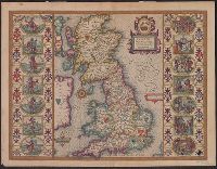
From Speed's The theatre of the empire of Great Britaine., Hand col. Sheet measures 42 x 55 cm. Lanman Collection., Left and right borders contain illustrations of notable persons from each of the 14 political districts., and Running title on verso: Heptarchiae
Publisher:
Are to be sold by John Sudbury & Georg. Humble,
Subject (Geographic):
Great Britain--Maps--Early works to 1800
Subject (Name):
Humble, George, d. 1640, Speed, John, 1552?-1629. Theatre of the Empire of Great Britaine, and Sudbury, John
Appears in William Camden's Camden's Britannia (1695)., Imprint derived from the earliest atlas in which the map was issued., London meridian., Relief shown pictorially., Shows Roman placenames., and Subsequently issued in the same state in several editions of the
Publisher:
[A. Swalle & A. & J. Churchill],
Subject (Geographic):
British Isles--Early works to 1800--Maps, Europe--British Isles, and Great Britain
Subject (Name):
Camden, William, 1551-1623. Britannia. English and Morden, Robert, approximately 1650-1703
Britannicae Insulae in quibus Albion seu Britannia Major, et Ivernia seu Britannia Minor
Description:
"Cum Privilegio Regis.", Appears in Gilles Robert de Vaugondy's Atlas Universel (1752 and later)., Prime meridian: Ferro., and Relief shown pictorially.
Publisher:
[Gilles Robert de Vaugondy?],
Subject (Geographic):
British Isles--Historical geography--Maps--Early works to 1800
Subject (Name):
Haye, G. de la, Robert de Vaugondy, Gilles, 1688-1766. Atlas universel., and Sanson, Nicolas, 1600-1667
Abtheilung V, Britisch Nord-America, Britisch Nord-America, I Blatt., and Britisch Nord-America, II Blatt.
Description:
At head of title: Abtheilung V., In lower right margin: Lith. u. gedr. im geogr. lith. Institut v. Albr. Platt., In upper right margin: Platt's grosser Atlas der Erde., No. 58 and 59., Prime meridian: Paris., Relief shown by hachures and spot heights., and Stamped
General map showing the explorations and surveys of the Expedition, 1907-1909 and The Geographical journal.
Description:
Map showing the area explored by Ernest Shackleton's British Antarctic Expedition, 1907-1909. The routes shown cover the areas explored or surveyed along the eastern coast of South Victoria Land, including the route of the South Magnetic Pole Party, and along the southern coastline of the Ross Sea. Shackleton's route towards the South Pole is also shown, including the southern-most point at 162E̊, 88S̊23'. Land relief is indicated by spot heights, hachures and contours.
Publisher:
Royal Geographical Society,
Subject (Geographic):
Antarctica--Discovery and exploration--Maps, South Magnetic Pole (Antarctica)--Discovery and exploration--Maps, South Pole--Discovery and exploration--Maps, and South Victoria Land (Antarctica)--Discovery and exploration--Maps
Subject (Name):
British Antarctic Expedition (1907-1909)--Maps, Royal Geographical Society (Great Britain). Australian Antarctic Division, and Shackleton, Ernest Henry Sir, 1874-1922
Subject (Topic):
Scientific expeditions--Antartica--South Victoria Land--Maps and Scientific expeditions--South Pole--Maps