Skip to search
Skip to main content
Skip to first result
Search
You Searched For
Genre
Maps
Language
English
Subject (Topic)
World War, 1914-1918--Maps
New Search
Search Results
Creator:
Published / Created:
1915
Call Number:
11hcf 1919E-19
Container / Volume:
BRBL_00010Z
Image Count:
1
Resource Type:
Maps, Atlases & Globes
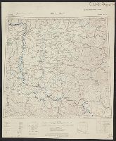
Alternative Title:
Europe 1:1,000,000, G.S.G.S. ; no. 2758, and GSGS (Series) ; no. 2758.
Description:
Copy 2: Col. ms. notes on map described as "Czechoslovakian Border". Inscription: Charles Seymour. and Includes index to adjoining sheets, index to boundaries, and pronunciation glossary.
Publisher:
Ordnance Survey,
Subject (Geographic):
Hungary--Maps
Subject (Name):
Seymour, Charles,--1885-1963--Autograph
Subject (Topic):
World War, 1914-1918--Maps
Found in:
Beinecke Rare Book and Manuscript Library > Buda Pest : North L 34. / compiled at the Royal Geographical Society under the direction of the Geographical Section; drawn and printed by Ordnance Survey.
Creator:
Published / Created:
1915
Call Number:
11hcf 1919E-19
Container / Volume:
BRBL_00010Z
Image Count:
1
Resource Type:
Maps, Atlases & Globes
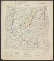
Alternative Title:
Europe 1:1,000,000, G.S.G.S. ; no. 2758, and GSGS (Series) ; no. 2758.
Description:
Copy 3: Ms. legend corresponding to col. ms. notes on map. On sheet 63 x 52 cm. Inscription: Charles Seymour. and Includes index to adjoining sheets, index to boundaries, and pronunciation glossary.
Publisher:
Ordnance Survey,
Subject (Geographic):
Hungary--Maps
Subject (Name):
Seymour, Charles,--1885-1963--Autograph
Subject (Topic):
World War, 1914-1918--Maps
Found in:
Beinecke Rare Book and Manuscript Library > Buda Pest : North L 34. / compiled at the Royal Geographical Society under the direction of the Geographical Section; drawn and printed by Ordnance Survey.
Creator:
Published / Created:
1915
Call Number:
11hcf 1919E-19
Image Count:
1
Resource Type:
Maps, Atlases & Globes
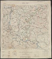
Alternative Title:
Europe 1:1,000,000, G.S.G.S. ; no. 2758, and GSGS (Series) ; no. 2758.
Description:
Copy 1: Col. ms. notes on map. and Includes index to adjoining sheets, index to boundaries, and pronunciation glossary.
Publisher:
Ordnance Survey,
Subject (Geographic):
Hungary--Maps
Subject (Name):
Seymour, Charles,--1885-1963--Autograph
Subject (Topic):
World War, 1914-1918--Maps
Found in:
Beinecke Rare Book and Manuscript Library > Buda Pest : North L 34. / compiled at the Royal Geographical Society under the direction of the Geographical Section; drawn and printed by Ordnance Survey.
Creator:
Published / Created:
[1914.]
Call Number:
11hc 1915B
Image Count:
2
Resource Type:
Maps, Atlases & Globes
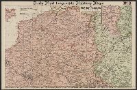
Alternative Title:
The Franco-Belgian Theatre of War
Description:
"The London Geographical Institute." printed outside lower right margin., Includes inset map "South East continuation of the Map on same scale.", and On verso: Key Map to the General European Situation, adv. and ill.
Publisher:
G. Philips & Son, Ltd.,
Subject (Geographic):
Belgium--Maps and France--Maps
Subject (Topic):
World War, 1914-1918--Maps
Found in:
Beinecke Rare Book and Manuscript Library > Daily Mail large-scale Military maps No. 3. : The Franco-Belgian Theatre of War / edited by George Philip, F.R.G.S., in conjunction with Military experts.
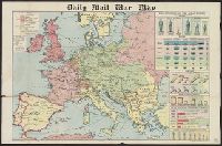
Creator:
Published / Created:
[1918?]
Call Number:
11hc 1914P
Image Count:
1
Resource Type:
Maps, Atlases & Globes
Alternative Title:
Daily mail (London, England)
Description:
"George Philip & Son, Ltd., The London Geographic Institute"--Left and right lower margins., Library's copy imperfect: torn., and On right margin: War Strength of the Great Powers: Armies, Navies, Aircraft, War Funds Available, Peace strength of the Great Power
Publisher:
Daily mail,
Subject (Geographic):
Europe--Maps
Subject (Topic):
World War, 1914-1918--Maps
Found in:
Beinecke Rare Book and Manuscript Library > Daily mail war map [cartographic material].
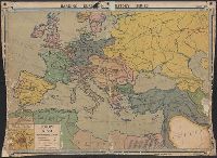
Creator:
Published / Created:
c1914.
Call Number:
30fab 1914
Container / Volume:
BRBL_00037B
Image Count:
1
Resource Type:
Maps, Atlases & Globes
Alternative Title:
Europe 1914.
Description:
Imperfect: mutilated with loss of text., Inset: Siege of Paris 1870-1871., and Third edition 1920.
Publisher:
Denoyer-Geppert Co.,
Subject (Geographic):
Europe--History--1871-1918--Maps
Subject (Topic):
World War, 1914-1918--Maps
Found in:
Beinecke Rare Book and Manuscript Library > Europe in 1914 before the Great War / by Samuel B. Harding ; L. Philip Denoyer, geographer ; compiled and drawn by R. Baxter Blair.
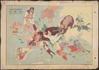
Creator:
Published / Created:
1914
Call Number:
30 1914E
Container / Volume:
BRBL_00032A
Image Count:
1
Resource Type:
Maps, Atlases & Globes
Description:
Caricature map. and Ill. of people and animals represent international relations.
Publisher:
"Geographia" Ltd.,
Subject (Geographic):
Europe--Maps
Subject (Topic):
International relations--20th century--Maps, World War, 1914-1918--Caricatures and cartoons, and World War, 1914-1918--Maps
Found in:
Beinecke Rare Book and Manuscript Library > European revue : kill that eagle / produced by "Geographia" Ltd. ; [drawn by] J.H.A.
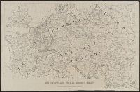
Published / Created:
1914
Call Number:
11hc 1914E
Container / Volume:
BRBL_00010A
Image Count:
1
Resource Type:
Maps, Atlases & Globes
Description:
"R6" printed to left of scale statement.
Publisher:
Army Service Schools,
Subject (Geographic):
Europe--Maps
Subject (Topic):
World War, 1914-1918--Maps
Found in:
Beinecke Rare Book and Manuscript Library > European war zone map / made at Army Service Schools, Fort Leavenworth, Kas.
Published / Created:
[1917?]
Call Number:
36hc 1917
Container / Volume:
BRBL_00133
Image Count:
1
Resource Type:
Maps, Atlases & Globes
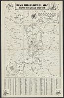
Description:
Index to names in margins.
Publisher:
Hobian Map Co.,
Subject (Geographic):
France--Maps and Germany--Maps
Subject (Name):
C.S. Hammond & Company Stamp
Subject (Topic):
World War, 1914-1918--Maps
Found in:
Beinecke Rare Book and Manuscript Library > Home Headquarters Map : French and German Frontiers.
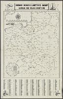
Published / Created:
[1917?]
Call Number:
36hc 1917a
Container / Volume:
BRBL_00133
Image Count:
1
Resource Type:
Maps, Atlases & Globes
Description:
Index to names in margins.
Publisher:
Hobian Map Co.,
Subject (Geographic):
Germany--Maps and Poland--Maps
Subject (Name):
C.S. Hammond & Company Stamp
Subject (Topic):
World War, 1914-1918--Maps
Found in:
Beinecke Rare Book and Manuscript Library > Home Headquarters Map : German and Polish Frontiers.
Branch:v1.61.6 ,Deployed:2024-06-12T09:55:36-04:00