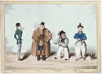
On the left a very thin and would-be fashionable young man stands in profile to the right, smoking a slim cigar. To his right a very broad hackney-coachman puffs at a very long clay pipe. He wears a long greatcoat with capes, over bulging coats and clumsy top-boots, with small top-hat. To his right a sailor in striped shirt and loose white trousers, chewing a quid with a pugnacious sideways look, stands full-face, taking tobacco from his box. On the far right a Frenchman stands full-face, taking a pinch from a snuff-box. A poodle stands beside him. His ear-rings, hat with truncated conical crown, and full white trousers gathered at the ankle indicate his nationality. See British Museum online catalogue
Description:
Title from caption below image., Sheet trimmed within plate mark., and State with imprint. Cf. Catalogue of prints and drawings in the British Museum. Division I, political and personal satires, v. 10, no. 14908.
Trade card for Thomas Obbinson from Sleaford Lincolnshire England, seller of teas, coffee, and, presumably, tobacco, depicts an enthroned American Indian smoking a long pipe. To his left side, a small Indian child fills a wooden barrel with leaves, another overturned barrel at his feet. In the background on the right are two sailing ships, one with the rigging up, the other at anchor, sails down
Description:
Title from item. and Below image: Teas coffee &c. wholesale & retail.
Publisher:
publisher not identified
Subject (Geographic):
Sleaford (Lincolnshire, England)
Subject (Topic):
Coffee industry, Sailing ships, Tea industry, and Tobacco industry
Title from caption below image., Approximate year of publication from British Museum online cat., Not in the Catalogue of prints and drawings in the British Museum. Division I, political and personal satires., and Watermark: J. Whatman.
Publisher:
Pub. by Geo. Hunt, corner of York St. & Bridges St.
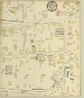
Sanborn fire insurance maps are a rich source of historic data on the urban built environment of North America during the 19th and early 20th centuries. The atlases were created for the purpose of underwriting fire insurance policies, which depended upon accurate and frequently-updated information about construction materials, municipal and transportation infrastructure, industrial and commercial landuse and more. The Yale University Library Map Department scanned its holdings of Sanborn fire insurance maps (consisting primarily of Connecticut towns) in order to make the maps more accessible.
Alternative Title:
Sept. 1884, Bethel, Conn.
Description:
"2 sheets.", Contains information on population, prevailing winds, water facilities and fire department., Partial cadastral map., and SMLMAPL 766 B467 1884: Sheets disbound. "Triplicate" stamp on all sheets. Library of Congress copyright stamp on title sheet.
Subject (Geographic):
Bethel (Conn.)--Maps
Subject (Name):
Library of Congress Stamp
Subject (Topic):
Fire risk assessment--Connecticut--Berlin--Maps and Real property--Connecticut--Bethel--Maps