Bowles's geographical game of Europe, in a new, complete, and elegant tour through the different kingdoms, states, cities, &c. of Europe : designed by Dr. Nugent and Game of Geography
Description:
Imperfect: wanting totum, pillars and counters., In pencil on verso: ""23"" on both the right and left sides, ""Hazel M. Osborn Fund"", ""pc259 98.2.9"", and ""Beinecke Library Osborn pc 259""., Includes publisher�s advertisements on map and case label., On verso: Yale proprietary stamp in center., and Text and hand colored map mounted on linen.
Publisher:
Printed for the proprietors Bowles & Carver
Subject (Topic):
Geographical recreations --Europe --Early works to 1800 and Publishers’ advertisements --England --London --1795
Europe divided into its principall parts viz. the Brittish [sic] Islands, Scandinavia, Moscovia, France, Germany, Poland, Spain, Italy, Turky [sic] in Europe ... described by Sanson, corrected and amended by William Berry
Description:
Dedicated To the most serene and most sacred majesty of Charles II ... by William Berry., Includes coat of arms and decorative cartouche containing dedication., No. 2 of 69 maps bound together in composite atlas., Prime meridian: Ferro., Relief shown pictorially., and Scale [ca. 1:75 000 000].
Publisher:
Sold by William Berry at ye sign of the globe between Charing-Cross and White-Hall
Subject (Geographic):
Europe --Maps --Early works to 1800, Russia --Maps --Early works to 1800, and Turkey --Maps --Early works to 1800
Bar scales given in Italian miles and com[m]on leagues of France., I. Harris, sc., Longitude east from London., No. 18 of 69 maps bound together in composite atlas., Relief shown pictorially., and Scale [ca. 1:2 300 000].
Publisher:
Improved and sold by Robt. Morden and Christopr. Browne at the Atlas in Cornhill and the Globe ye Westend of St. Pauls
Subject (Geographic):
Italy --History --1559-1789 --Maps and Italy --Maps --Early works to 1800
Italy divided according as its severall principalities extend, which are the territories of the Church, of the Catholick king, which contain the kingdomes of Naples, Sicily, Sardinia, and the Dukedome of Millain ... described by Sanson, corrected and amended by Will. Berry
Description:
Bar scales given in Italian miles, common leagues of Germany, great German leagues, common leagues of France, great French leagues, and common leagues of Spain., Dedicated To the most serene and most sacred majesty of Charles II ... by William Berry., No. 16 of 69 maps bound together in composite atlas., Relief shown pictorially., and Scale [ca. 1:2 300 000].
Publisher:
Sold by William Berry at the signe of the Globe between Charing-Cross and White Hall
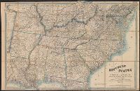
A list of other maps and atlases by Wyld is pasted on the verso., Description derived from published bibliography., and General map showing "dividing line between the free & slave-holding states."
Mediterranean Sea divided into the eastern and western seas, subdivides into its principal parts or seas ... described by Sanson, corrected and amended by William Berry
Description:
Based on La Mer Mediterranee divisee enses Principales Parties, ou Mers by Nicolas Sanson., Dedicated To the most serene and most sacred majesty James II ... by William Berry., Ms. mathematical annotations in left margin., No. 23 of 69 maps bound together in composite atlas., Relief shown pictorially., and Scale [ca. 1:610 000].
Publisher:
Sold by William Berry at the signe of the Globe between Charing-Cross and White-Hall
Part of the circle of Austria in which are the Dukedomes of Stiria, and Carinthia, of Carniola, in which are comprehended the countys of Chilley, and of Gorice, Windis-Marke, or Marquisat of Windes, described by Sanson, corrected and amended by William Berry
Description:
Bar scales in Italian miles, common leagues of Germany, great leagues of Germany, leagues of Hungary, common leagues of France, and great leagues of France or one hours travelling., Dedicated to The most high mighty and most excellent prince ----------------- prince of England, Scotland, France and Ireland, and Duke of Cornwall by William Berry, Ferro meridian., No. 28 of 69 maps bound together in composite atlas., Relief shown pictorially., and Scale [ca. 1:660 000].
Publisher:
Sold by William Berry at the sign of the Globe between Charing-Cross, and White-Hall
Part of the circle of Austria viz. the Archdukedom of Austria divided into the higher above the river Ens, and the lower below the Ens ... described by Sanson, corrected and amended by William Berry
Description:
Bar scales in Italian miles, common leagues of Germany, great leagues of Germany, leagues of Hungary, common leagues of France, and leagues of one hours travelling., Dedicated To the most serene and most sacred majesty James II ... by William Berry., Ferro meridian., No. 27 of 69 maps bound together in composite atlas., Relief shown pictorially., and Scale [ca. 1:510 000].
Publisher:
Sold by William Berry at the sign of the Globe between Charing-Cross, and White-Hall
Territories of the crown of Poland subdivided into their severall palatinates ... described by Sanson, corrected and amended by William Berry
Description:
Bar scales in Italian miles, common leagues of France, common leagues of Germany, leagues of Hungary, common leagues of Poland, and great leagues of Poland., Dedicated To the most serene and most sacred majesty of Charles II ... by William Berry., Ferro meridian., No. 39 of 69 maps bound together in composite atlas., Relief shown pictorially., and Scale [ca. 1:2 100 000].
Publisher:
Sold by William Berry at the sign of the Globe between Charing-Cross and White-Hall