Skip to search
Skip to main content
Skip to first result
Search
You Searched For
Resource Type
Maps, Atlases & Globes
Language
English
New Search
Search Results
Creator:
Published / Created:
[1847?]
Call Number:
88hc M57 1847B
Container / Volume:
BRBL_00649
Image Count:
1
Resource Type:
Maps, Atlases & Globes
Alternative Title:
Senate executive document (United States. Congress. Senate) ; 30th Congress, 1st session, no. 1.
Description:
Appears in Senate executive document, 30th Congress, 1st session, no. 1., Indexed., and Relief shown by hachures.
Publisher:
P.S. Duval's Lith.,
Subject (Geographic):
Mexico City (Mexico)--History--American occupation, 1847-1848--Maps
Subject (Name):
Duval, Peter S., 1804 or 5-1886, McClellan, George Brinton, 1826-1885, and Turnbull, Wm. (William), 1800-1857
Subject (Topic):
Mexican War, 1846-1848--Maps
Found in:
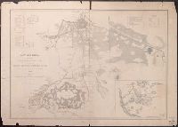
Beinecke Rare Book and Manuscript Library > Battles of Mexico : line of operations of the U.S. Army under the command of Major General Winfield Scott on the 8th, 12th and 13th of September, 1847 / surveyed by Maj. Turnbull, Capt. McClellan, and Lieut. Hardcastle, Corps of Top. Engineers ; drawn by
Published / Created:
1848
Call Number:
88hc M57 1847
Container / Volume:
BRBL_00649
Image Count:
1
Resource Type:
Maps, Atlases & Globes
Subject (Geographic):
Mexico--Maps
Found in:
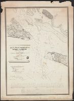
Beinecke Rare Book and Manuscript Library > Battles of Mexico [City]. Survey of the line of operations of the U.S. Army under command of Major general Winfield Scott, on the 19th and 20th August and on the 8th, 12th, & 13th September, 1847 ... U.S. War Dept., 1848.
Published / Created:
1839
Call Number:
785cea B382 1839
Container / Volume:
BRBL_00514
Image Count:
1
Resource Type:
Maps, Atlases & Globes
Description:
Lithy. of P. Haas.
Subject (Geographic):
North Carolina--Maps
Found in:
Beinecke Rare Book and Manuscript Library > Baufort Harbour North Carolina ... By Liutenant James Glynn ...
Published / Created:
1918
Call Number:
3627 1918
Image Count:
1
Resource Type:
Maps, Atlases & Globes
Description:
"G.S.G.S No. 2875".
Publisher:
War Office,
Subject (Geographic):
Bavaria (Germany)--Maps and Palatinate (Germany)--Maps
Found in:
Beinecke Rare Book and Manuscript Library > Bavarian Palatinate : with Birkenfeld and part of Rhenish Prussia.
Call Number:
1973 Folio 114
Collection Title:
The English pilot: describing the West-India navigation, from Hudson's-Bay to the river Amazones
Image Count:
1
Resource Type:
Maps, Atlases & Globes
Subject (Geographic):
Atlantic Ocean --Maps --Early works to 1800 and Newfoundland and Labrador --Maps --Early works to 1800
Subject (Topic):
Navigation --Early works to 1800, Pilot guides --Atlantic Coast (U.S.) --Early works to 1800, and Pilot guides --Caribbean Area --Early works to 1800
Collection Created:
London : Printed for W. and J. Mount, T. Page and son, on Tower-Hill, MDCCLIX [1759]
Found in:
Beinecke Rare Book and Manuscript Library > Bay Bulls, part of Newfoundland
Creator:
Published / Created:
[1949]
Call Number:
844gmb Sa52 1949A
Container / Volume:
BRBL_00618
Image Count:
2
Resource Type:
Maps, Atlases & Globes
Description:
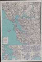
"C30944" below copyright and "1947" on panel., "Copyright by Automobile Club of Southern California.", "Map Number 1927.", Includes insets of Sacramento, Stockton, Santa Clara, Santa Cruz, and "San Francisco and East Bay cities.", Index and ill. on verso., and Relief shown by shading and spot heights.
Publisher:
Automobile Club of Southern California,
Subject (Geographic):
San Francisco Bay Area (Calif.)--Maps
Subject (Topic):
Roads--California--San Francisco Bay Area--Maps
Found in:
Beinecke Rare Book and Manuscript Library > Bay and rivers quadrangle.
Creator:
Published / Created:
[1943]
Call Number:
382 1943
Container / Volume:
BRBL_00175
Image Count:
1
Resource Type:
Maps, Atlases & Globes
Description:
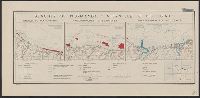
"22 November 1943.", "Map no. 2438.", and Relief shown by contours; depths shown by isolines.
Publisher:
Reproduction Branch, OSS,
Subject (Geographic):
Normandy (France)--Maps
Subject (Topic):
Beaches--France--Normandy--Maps
Found in:
Beinecke Rare Book and Manuscript Library > Beaches of Normandy - Vierville to Houlgate [cartographic material] / compiled and drawn in the Branch of Research and Analysis, OSS.
Creator:
Published / Created:
1971
Call Number:
739 1971
Container / Volume:
BRBL_00389
Image Count:
2
Resource Type:
Maps, Atlases & Globes
Alternative Title:
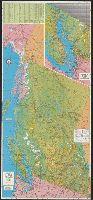
British Columbia
Description:
On recto: index and inset: Vancouver, Victoria and vicinity., On verso: text on points of interest, hunting and fishing information, and col. ill., Panel title., and Relief shown by shading and spot heights.
Publisher:
Grant-Mann Lithographers,
Subject (Geographic):
British Columbia--Maps
Subject (Name):
British Columbia. Dept. of Travel Industry and Grant-Mann Lithographers Limited
Subject (Topic):
Outdoor recreation--British Columbia--Maps and Roads--British Columbia--Maps
Found in:
Beinecke Rare Book and Manuscript Library > Beautiful British Columbia [cartographic material] : 1971-1972 road map, campground & fishing guide / G.E. Brenner, cartographer.
Published / Created:
1749
Call Number:
3239 1749
Container / Volume:
BRBL_00065
Image Count:
1
Resource Type:
Maps, Atlases & Globes
Description:
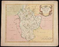
Preliminary record.
Subject (Geographic):
Bedfordshire (England)--Maps--Early works to 1800
Found in:
Beinecke Rare Book and Manuscript Library > Bedford ... by Eman: Bowen ...
Creator:
Published / Created:
[1695]
Call Number:
BrSides Folio 2019 85
Image Count:
1
Resource Type:
Maps, Atlases & Globes
Alternative Title:
Bedfordshire
Description:
First state, produced prior to changes before 1722., From: Camden's Britannia, newly translated into English ... [London] : Printed by F. Collins, for A. Swalle ... and A. & J. Churchil ..., 1695., London meridian., Relief shown pictorially., and Shows boundaries, rivers, roads, woods, parks and settlements.
Publisher:
Sold by Abel Swale, Awnsham & Iohn Churchil,
Subject (Geographic):
Bedfordshire (England)--Maps--Early works to 1800.
Subject (Name):
Camden, William, 1551-1623. Britannia. English., Churchill, Awnsham, -1728, Churchill, John, active 1690-1714, and Swall, Abel
Found in:
Beinecke Rare Book and Manuscript Library > Bedford Shire / by Robt. Morden.
Branch:v1.61.6 ,Deployed:2024-06-12T09:55:33-04:00