Search
You Searched For
Search Results
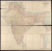
- Creator:
- Walker, John, 1786-1873, cartographer
- Published / Created:
- 1882.
- Call Number:
- Covers 59 +1882
- Image Count:
- 2
- Resource Type:
- cartographic image
- Found in:
- Beinecke Rare Book and Manuscript Library > Map of India : shewing the British territories, subdivided into collectorates and including British Burmah, with the position and boundary of each native state
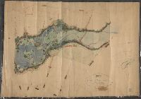
- Creator:
- Mitchell, Donald Grant, 1822-1908, cartographer
- Published / Created:
- Decr. 1863.
- Call Number:
- Roll Map 78
- Image Count:
- 2
- Resource Type:
- cartographic image
- Found in:
- Beinecke Rare Book and Manuscript Library > Map of a portion of Westville & New Haven
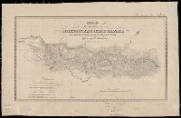
- Creator:
- Goddard, George H. (George Henry), 1817-1906, cartographer
- Published / Created:
- [1855?]
- Call Number:
- BrSides Zc72 855gn
- Image Count:
- 2
- Resource Type:
- cartographic image
- Found in:
- Beinecke Rare Book and Manuscript Library > Map of a survey of the Mokelumne Hill Canal and a reconnoissance of the adjoining country / [cartographic material]
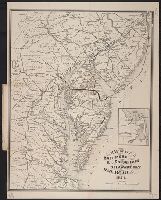
- Creator:
- J.L. Smith Co., cartographer, publisher
- Published / Created:
- 1874.
- Call Number:
- 754gme 1874
- Image Count:
- 1
- Resource Type:
- cartographic image
- Found in:
- Beinecke Rare Book and Manuscript Library > Map of the Baltimore, Chesapeake & Delaware Bay Railroad
- Creator:
- Searle, S.W., cartographer
- Published / Created:
- 1859.
- Call Number:
- 766 N46 1859
- Image Count:
- 1
- Resource Type:
- cartographic image
- Found in:
- Beinecke Rare Book and Manuscript Library > Map of the city of New Haven, Connecticut
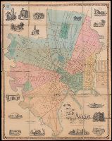
- Creator:
- Scott, F. H., Major, cartographer
- Published / Created:
- 1855.
- Call Number:
- Covers 59 1855
- Image Count:
- 4
- Resource Type:
- cartographic image
- Found in:
- Beinecke Rare Book and Manuscript Library > Map of the peninsula of India, comprising the whole of the Madras Presidency, and portions of the adjacent territories of Bengal and Bombay [cartographic material]
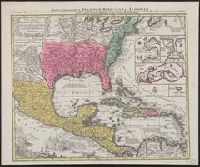
- Creator:
- Lotter, Tobias Conrad, 1717-1777, cartographer
- Published / Created:
- [between 1741 and 1760]
- Call Number:
- 85 1740D
- Image Count:
- 1
- Resource Type:
- cartographic image
- Found in:
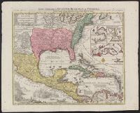
- Beinecke Rare Book and Manuscript Library > Mappa geographica regionem Mexicanam et Floridam terrasque adjacentes, ut et anteriores Americae insulas, cursus itidem et reditus navigantium versus flumen Missisipi et alias colonias ob oculos ponens / [cartographic material]
- Creator:
- Lotter, Tobias Conrad, 1717-1777, cartographer
- Published / Created:
- [between 1741 and 1760]
- Call Number:
- 71 1737A
- Image Count:
- 1
- Resource Type:
- cartographic image
- Found in:
- Beinecke Rare Book and Manuscript Library > Mappa geographica regionem Mexicanam et Floridam terrasque adjacentes, ut et anteriores Americae insulas, cursus itidem et reditus navigantium versus flumen Missisipi et alias colonias ob oculos ponens / [cartographic material]
- Creator:
- United States. War Department. Corps of Engineers, cartographer, publisher
- Published / Created:
- [1881]
- Call Number:
- 831 1881A
- Image Count:
- 2
- Resource Type:
- cartographic image
- Found in:
- Beinecke Rare Book and Manuscript Library > Montana Territory
- Creator:
- United States. War Department. Corps of Engineers, cartographer, publisher
- Published / Created:
- [1875?]
- Call Number:
- 831 1875
- Image Count:
- 1
- Resource Type:
- cartographic image
- Found in:
- Beinecke Rare Book and Manuscript Library > Montana Territory