Includes inset showing railway across all of Canada, "Map of the Canadian Pacific Railway, (Pacific Division) and connections on the Pacific Coast," and time tables., Relief shown by hachures., and Time tables, text, and ill. on verso.
"12-20'27" and "5410." and Includes inset of "Canadian Pacific Railway and steamship lines."
Publisher:
Poole Bros.,
Subject (Geographic):
Canada--Maps and United States--Maps
Subject (Name):
Canadian Pacific Railway Company, Duluth, South Shore, and Atlantic Railway Company, Duluth, South Shore, and Atlantic Railway Company--Maps, and Spokane International Railway--Maps
Subject (Topic):
Railroads--Canada--Maps and Railroads--United States--Maps
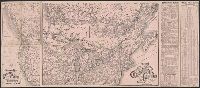
Sportsman's map of Canada and the Northwest Territory.
Description:
Date taken from Yale card catalog indicating map was originally in cover with date of issue, March 1901; also with a cover title, "The sportsman's map of Canada and the Northwest Territory." and Relief shown by hachures.
Publisher:
Poole Bros.,
Subject (Geographic):
Canada--Maps and United States--Maps
Subject (Name):
Canadian Pacific Railway Company, Canadian Pacific Railway Company--Maps, Duluth, South Shore, and Atlantic Railway Company, and Duluth, South Shore, and Atlantic Railway Company--Maps
Subject (Topic):
Railroads--Canada--Maps and Railroads--United States--Maps
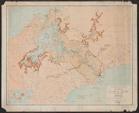
Coordinates not present on map and are approximated., Dissected and mounted on linen., Ill. title cartouche with views of the Old State House and Faneuil Hall., Includes index for streets and buildings., and Shows names of streets, railroads, bridges, wharfs, and other points of interest; districts numbered, public buildings and offices identified.
Publisher:
Geo. W. Stadly & Co.,
Subject (Geographic):
Boston (Mass.)--Maps and Massachusetts--Boston
Subject (Topic):
Central business districts and Central business districts--Massachusetts--Boston--Maps