Dukedom of Pomerania, which comprehended into the circle of the Upper Saxony divided as it is att present parted betweene the crown of Sweden and the elector of Brandenbourg ... described by Sanson, corrected & amended by William Berry
Description:
Bar scales in Italian miles, common leagues of Germany, great leagues of Germany, and common leagues of France., Dedicated To the most serene and most sacred majty. James II ... by William Berry., Ferro meridian., No. 36 of 69 maps bound together in composite atlas., Relief shown pictorially., and Scale [ca. 1:570 000].
Publisher:
Sold by William Berry at the signe of the Globe between Charing-Cross, and White-Hall
Subject (Geographic):
Pomerania (Poland and Germany) --Maps --Early works to 1800
Empire of Germany in which are distinguished the dominions of the house of Austria, the ecclesiasticall electors of Metz, Treves, and Colen ... described by Sanson, corrected and amended by William Berry
Description:
Bar scales in Italian miles, common leagues of Germany, great leagues of Germany, common leagues of France, great leagues of France or common leagues of Poland, great leagues of Poland, leagues of Hungary, and leagues of one houers travelling., Dedicated To the most serene and most sacred majesty James II ... by William Berry., Ferro meridian., No. 26 of 69 maps bound together in composite atlas., Relief shown pictorially., and Scale [ca. 1:2 100 000].
Publisher:
Sold by William Berry at the sign of the Globe, between Charing-Cross, and White-Hall
Dominions or empire of the great Turke in Europe, Asia, and Africa ... described by Sanson, corrected and amended by Will. Berry
Description:
Bar scales in Italian miles, common leagues of France, great leagues of France, common leagues of Germany or great leagues of Poland, leagues of Hungary, and Persian leagues of one houres travilling., Dedicated to James II by William Berry., Ferro meridian., No. 50 of 69 maps bound together in composite atlas., Relief shown pictorially., and Scale [ca. 1:8 600 000].
Publisher:
Sold by William Berry at the signe of the Globe between Charing Cross, and White Hall
Subject (Geographic):
Africa, North --Maps --Early works to 1800, Arabian Peninsula --Maps --Early works to 1800, Mediterranean Region --Maps --Early works to 1800, and Turkey --Maps --Early works to 1800
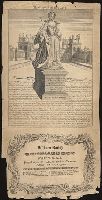
Engraving showing the statue of Queen Anne at Blenhiem Palace (in background), and text of inscription by Sarah Marlborough, dated 1738, with imprint: London, Printed & published ... by R. Walker, in Fleet Lane.