Search
You Searched For
Search Results
- Published / Created:
- [1920?].
- Call Number:
- 38gmb 1920A
- Container / Volume:
- BRBL_00170
- Image Count:
- 4
- Resource Type:
- Maps, Atlases & Globes
- Found in:
- Beinecke Rare Book and Manuscript Library > Carte routière de France de Dion-Bouton : spéciale pour automobiles / Dressée au Service Cartographique de Dion-Bouton.
- Creator:
- Hoebel, Paul
- Published / Created:
- 1910
- Call Number:
- 56 1901
- Container / Volume:
- BRBL_00296
- Image Count:
- 4
- Resource Type:
- Maps, Atlases & Globes
- Found in:
- Beinecke Rare Book and Manuscript Library > Hoebels Karte v. China [cartographic material] / gezeichnet und übersetzt von Paul Hoebel, Terrainzeichnung von F. Pilger.
- Creator:
- Ordnance Survey of Ireland
- Published / Created:
- [188-]
- Call Number:
- 327 1875
- Container / Volume:
- BRBL_00073
- Image Count:
- 4
- Resource Type:
- Maps, Atlases & Globes
- Found in:
- Beinecke Rare Book and Manuscript Library > A general map of Ireland : showing the county and barony boundaries, the rivers, railways, canals, leading roads and principal demesnes ... (New Edition).
- Published / Created:
- 1808
- Call Number:
- 89cea 1808
- Container / Volume:
- BRBL_00658
- Image Count:
- 4
- Resource Type:
- Maps, Atlases & Globes
- Found in:
- Beinecke Rare Book and Manuscript Library > A General Chart of the West Indies and Gulf of Mexico, describing the Gulf and Winward Passages, Coasts of Florida, Louisiana and Mexico, Bay of Honduras and Musquito Shore ... Drawn from the surveys taken by Mr. Geo Gaulo ... by Foss Dessiou.
- Published / Created:
- 1905
- Call Number:
- 771 Ad47 1905
- Container / Volume:
- BRBL_00480
- Image Count:
- 4
- Resource Type:
- Maps, Atlases & Globes
- Found in:
- Beinecke Rare Book and Manuscript Library > Map of the Adirondack Forest and adjoining territory / compiled from the official maps and field notes on file in the state departments at Albany, N.Y. ; by authority of the Forest, Fish, and Game Commission.
- Creator:
- American Geographical Society of New York
- Published / Created:
- 1918
- Call Number:
- 44cbd 1918
- Container / Volume:
- BRBL_00256
- Image Count:
- 4
- Resource Type:
- Maps, Atlases & Globes
- Found in:
- Beinecke Rare Book and Manuscript Library > Block diagram showing terrain of the Balkan Peninsula [cartographic material].
- Creator:
- Beers, S. N
- Published / Created:
- 1859
- Call Number:
- 771 On8 1859
- Container / Volume:
- BRBL_00490
- Image Count:
- 4
- Resource Type:
- Maps, Atlases & Globes
- Found in:
- Beinecke Rare Book and Manuscript Library > Map of Ontario County, New York : from actual surveys / by S.N. Beers, assisted by D.G. Beers.
- Creator:
- Pownall, Thomas, 1722-1805
- Published / Created:
- March 25th, 1776.
- Call Number:
- 71 1776N
- Container / Volume:
- BRBL_00726
- Image Count:
- 4
- Resource Type:
- Maps, Atlases & Globes
- Found in:
- Beinecke Rare Book and Manuscript Library > A map of the middle British colonies in North America [cartographic material] : First published by Lewis Evans, of Philadelphia, in 1755 ; and since corrected and improved, as also extended, with the addition of New England, and bordering parts of Canada
- Creator:
- Beer, Wilhelm, 1797-1850
- Published / Created:
- 1834
- Call Number:
- 4 1835
- Container / Volume:
- BRBL_00196
- Image Count:
- 4
- Resource Type:
- Maps, Atlases & Globes
- Found in:
- Beinecke Rare Book and Manuscript Library > Mappa selenographica [cartographic material] : totam lunae hemisphaeram visibilem complectens observationibus propriis : quatuor sectionibus constructa et delineata / Suae Majestati Friderico Sexto, regi daniae illustrissimo summa veneratione dedicata ; a
- Published / Created:
- 1913
- Call Number:
- 428 Ot9 1913
- Container / Volume:
- BRBL_00249
- Image Count:
- 4
- Resource Type:
- Maps, Atlases & Globes
- Found in:
- Beinecke Rare Book and Manuscript Library > Oetzthal & Stubai.
- Creator:
- Walling, Henry Francis, 1825-1888
- Published / Created:
- 1858
- Call Number:
- 764 B45 1858
- Container / Volume:
- BRBL_00454
- Image Count:
- 6
- Resource Type:
- Maps, Atlases & Globes
- Found in:
- Beinecke Rare Book and Manuscript Library > Map of the county of Berkshire, Massachusetts : based upon the trigonometrical survey of the state / the details from actual surveys under the direction of Henry F. Walling, supt. of the state map.
- Published / Created:
- 1861
- Call Number:
- 771fab 1861
- Container / Volume:
- BRBL_00493
- Image Count:
- 6
- Resource Type:
- Maps, Atlases & Globes
- Found in:
- Beinecke Rare Book and Manuscript Library > Map of the boundary line between the states of New York and Connecticut, to accompany the report of the New York Commissioners/ H.S. Dewy, Engineer, John Evans, Assistant.
- Creator:
- Hoempler, Carlos E. C
- Published / Created:
- 1906
- Call Number:
- 9739 1906
- Container / Volume:
- BRBL_00678
- Image Count:
- 6
- Resource Type:
- Maps, Atlases & Globes
- Found in:
- Beinecke Rare Book and Manuscript Library > Mapa del departamento de Loreto [cartographic material] / correjido y aumentado con los estudios los Srs. Espinar, Buenaño, Mavila, Zavala, Donayre, Von Hassel y otros ; trazado y dibujo de los cartografos Hoempler, Baluarte y Vallejos.
- Creator:
- United States. Army Map Service
- Published / Created:
- 1943
- Call Number:
- 5844 1943
- Container / Volume:
- BRBL_00315
- Image Count:
- 6
- Resource Type:
- Maps, Atlases & Globes
- Found in:
- Beinecke Rare Book and Manuscript Library > Malaya 1:253 440 : Pahang.
- Creator:
- United States. General Land Office
- Published / Created:
- 1876
- Call Number:
- 75 1876
- Container / Volume:
- BRBL_00405
- Image Count:
- 6
- Resource Type:
- Maps, Atlases & Globes
- Found in:
- Beinecke Rare Book and Manuscript Library > Map of the United States and territories, showing the extent of public surveys, Indian and military reservations, land grant R.R., rail roads, canals, and other details / compiled from the official surveys of the General Land Office, and other authentic s
- Published / Created:
- [ca. 1870]
- Call Number:
- 428 1870
- Container / Volume:
- BRBL_00248
- Image Count:
- 6
- Resource Type:
- Maps, Atlases & Globes
- Found in:
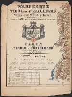
- Beinecke Rare Book and Manuscript Library > Wandkarte von Tirol und Vorarlberg für Volks-und Mittel-Schulen = Carta del Tirolo e Vorarlberg ad uso di scuole popolari e medie / Gezeichnet von G.v. Kaler.
- Creator:
- Mexico. Dirección de Estudios Geográficos y Climatológicos
- Published / Created:
- 1927?]
- Call Number:
- 8819 1927
- Container / Volume:
- BRBL_00652
- Image Count:
- 6
- Resource Type:
- Maps, Atlases & Globes
- Found in:
- Beinecke Rare Book and Manuscript Library > Estado de Chihuahua / Secretaria de Agricultura y Fomento, Direccion de Estudios Geográficos y Clim. ; Dep. Geográfico de Gabinete, Dep. Geogr. de Campo.
- Published / Created:
- 1909
- Call Number:
- 61 1909A
- Container / Volume:
- BRBL_00331
- Image Count:
- 6
- Resource Type:
- Maps, Atlases & Globes
- Found in:
- Beinecke Rare Book and Manuscript Library > Map of Egypt.
- Published / Created:
- 1799
- Call Number:
- 90 1799A
- Container / Volume:
- BRBL_00662
- Image Count:
- 6
- Resource Type:
- Maps, Atlases & Globes
- Found in:
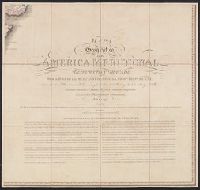
- Beinecke Rare Book and Manuscript Library > Mapa Geográfico de America Meridionale, Dispuesto y Gravado por de Juan de la Cruz Cano y Olmedilla, Geogfo. Pensdo. de S.M. Individluo de la Rl. Academia de Sn. Fernando, y de la Sociedad Bascongada de los Amigos de Pais, teniendo presentes Varios Mapas
- Published / Created:
- 1811
- Call Number:
- 90 1819
- Container / Volume:
- BRBL_00662
- Image Count:
- 6
- Resource Type:
- Maps, Atlases & Globes
- Found in:
- Beinecke Rare Book and Manuscript Library > Outlines of the Physical and Political Divisions of South America: delineated by A. Arrowsmith partly from scarse and Original Documents, published before the year 1806 corrected from accurate Astronomical observations to 1810.