Skip to search
Skip to main content
Skip to first result
Search
You Searched For
Genre
Engravings
Genre
Illustrations
Language
English
New Search
Search Results
Call Number:
2006 +S45
Collection Title:
Banter (London, England : 1867)
Image Count:
1
Resource Type:
Books, Journals & Pamphlets
Description:
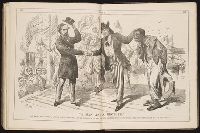
Second caption: Uncle Sam.-"Wal, Charley, I guess you're welcome; let me introduce to you our new brother from down south- 'the most remarkable man in the country.'"
Subject (Name):
Sala, George Augustus, 1828-1895
Subject (Topic):
English wit and humor --Periodicals
Collection Created:
London : Samuel Taylor, Printer, 1867-1868
Found in:
Beinecke Rare Book and Manuscript Library > "A Man and a brother."
Creator:
Published / Created:
[ca. 1860?]
Call Number:
Shirley +285
Collection Title:
Funny leaves for the younger branches / by Baron Krakemsides of Burstenoudelafen
Image Count:
2
Resource Type:
Books, Journals & Pamphlets
Description:
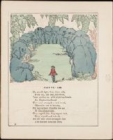
Page 13.
Subject (Topic):
Children’s poetry, Elephants --Juvenile poetry, and Hunting --Juvenile poetry
Collection Created:
Philadelphia : Willis P. Hazard, 724 Chestnut Street, [ca. 1860?]
Found in:
Beinecke Rare Book and Manuscript Library > "The Verdict"
Creator:
Call Number:
Shirley +285
Collection Title:
Funny leaves for the younger branches / by Baron Krakemsides of Burstenoudelafen
Image Count:
2
Resource Type:
Books, Journals & Pamphlets
Description:
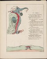
Page 12.
Subject (Topic):
Children’s poetry, Elephants --Juvenile poetry, and Hunting --Juvenile poetry
Collection Created:
Philadelphia : Willis P. Hazard, 724 Chestnut Street, [ca. 1860?]
Found in:
Beinecke Rare Book and Manuscript Library > "They try him"
Published / Created:
1850
Call Number:
1976 Folio 96
Collection Title:
A new universal atlas containing maps of the various empires, kingdoms, states and republics of the
Image Count:
1
Resource Type:
Maps, Atlases & Globes
Publisher:
Thomas, Cowperthwait & Co
Subject (Geographic):
Connecticut
Collection Created:
Philadelphia, Cowperthwait, DeSilver & Butler, 1854, c1850
Found in:
Beinecke Rare Book and Manuscript Library > 10. Map of Connecticut
Published / Created:
1846
Call Number:
1976 Folio 93
Collection Title:
A new universal atlas containing maps of the various empires, kingdoms, states and republics of the
Image Count:
1
Resource Type:
Maps, Atlases & Globes
Publisher:
S. Augustus Mitchell
Subject (Geographic):
Connecticut
Collection Created:
Philadelphia, S.A. Mitchell, 1847, c1844
Found in:
Beinecke Rare Book and Manuscript Library > 9. Connecticut
Creator:
Published / Created:
[1801?]
Call Number:
1986 400
Image Count:
35
Publisher:
Printed by R. Raikes, and sold by Washbourn, Hough, Roberts, and Bullock, Glocester, and at Broomesberrow Place
Subject (Name):
Greene, Richard, 1716-1793 --Museums, relics, etc and Yate, Walter Honywood --Museums, relics, etc.
Subject (Topic):
Curiosities and wonders --Private collections
Found in:
Beinecke Rare Book and Manuscript Library > A Concise and descriptive catalogue of all the natural and artificial curiosities in the museum of W.H. Yate, Esq. at Bromesberrow-Place near Glocester : being the extensive and valuable collection of the late Dr. Greene, of Lichfield, with many additions
Creator:
Published / Created:
1794 July 26
Call Number:
1986 102
Collection Title:
An historical, geographical, commercial, and philosophical view of the American United States, and
Image Count:
1
Description:
Engraved by J. Russell, Constitution Row, Grays Inn Lane. and Facing p. 157.
Publisher:
Publish'd as the Act directs, by H.D. Symonds, No. 20 Pater Noster Row
Subject (Geographic):
America --Description and travel, America --History --To 1810, United States --Description and travel, and United States --Maps --Early works to 1800
Collection Created:
London, Printed for the editor; J. Ridgway [etc.] 1795
Found in:
Beinecke Rare Book and Manuscript Library > A General map of North America drawn from the best sources
Published / Created:
1776
Call Number:
Cb23 27
Collection Title:
The American military pocket atlas : being an approved collection of correct maps, both general and
Image Count:
1
Alternative Title:
The Seat of war, in the northern colonies, containing the province of Quebec, Newfoundland, Nova-Scotia, New-England, New-York, New-Jersey, Pennsylvania, &ca
Description:
14th August 1776. and Teaching resource: Professor John Mack Faragher, History 141: The American West.
Publisher:
Printed for Robt. Sayer & Jno. Bennett, Map and Sea Chartsellers, No. 53, Fleet Street, as the Act directs
Subject (Geographic):
New England --Maps --Early works to 1800, North America --Maps --Early works to 1800, and United States --History --Revolution, 1775-1783 --Maps
Collection Created:
London : Printed for R. Sayer and J. Bennet, [1776]
Found in:
Beinecke Rare Book and Manuscript Library > A General map of the northern British colonies in America. which comprehends the province of Quebec, the government of Newfoundland, Nova-Scotia, New-England and New-York. From the maps published by the Admiralty and Board of Trade regulated by the astronomic and trigonometric observations of M. von Holland and corrected from Governor Pownall's late map 1776.
Creator:
Published / Created:
1776
Call Number:
Cb23 27
Collection Title:
The American military pocket atlas : being an approved collection of correct maps, both general and
Image Count:
1
Alternative Title:
The Seat of war, in the southern British colonies, comprehending North and South Carolina, Georgia, east and west Florida, &ca
Description:
15th Oct. 1776., Inset: Plan of Charlestown and plan of St. Augustine., and Teaching resource: Professor John Mack Faragher, History 141: The American West.
Publisher:
Printed for R. Sayer & J. Bennett, Map, Chart and Printsellers, No. 53 Fleet Street, as the Act directs
Subject (Geographic):
North America --Maps --Early works to 1800, Southern States --Maps --Early works to 1800, and United States --History --Revolution, 1775-1783 --Maps
Collection Created:
London : Printed for R. Sayer and J. Bennet, [1776]
Found in:
Beinecke Rare Book and Manuscript Library > A General map of the southern British colonies, in America, comprehending North and South Carolina, Georgia, east and west Florida, with the neighbouring Indian countries. From the modern surveys of engineer de Brahm, Capt. Collet, Mouzon & others; and from the large hydrographical survey of the coasts of east and west Florida
Call Number:
Egf 789
Collection Title:
The American geography; or, A view of the present situation of the United States of America
Image Count:
1
Description:
Preceding p. 33.
Subject (Geographic):
France --History --Revolution, 1789-1799, United States --Description and travel, and United States --Maps --Early works to 1800
Subject (Topic):
Geography --Textbooks --Early works to 1800 and Maps --United States --1788
Collection Created:
Elizabeth Town : Printed by Shepard Kollock, for the author, M,DCC,LXXXIX
Found in:
Beinecke Rare Book and Manuscript Library > A Map of the northern and middle states; comprehending the western Territory and the British dominions in North America. Compiled from the best authorities
Branch:v1.64.0 ,Deployed:2024-09-11T10:25:15-04:00