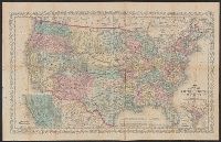
"Entered according to Act of Congress in the year 1856 by Charles Desilver in the clerks office of the District Court of the Eastern District, Also shows proposed western railroad routes., Prime meridians Washington and Greenwich., and Relief shown by hachures.
Publisher:
Charles Desilver,
Subject (Geographic):
United States--Maps
Subject (Name):
Desilver, Charles, Hazzard J. L, and Yeager, E. (Edward)
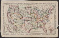
"Entered according to Act of Congress in the year 1859 by Charles Desilver in the clerks office of the District Court of, Also shows battle fields and proposed western railroad routes., Includes decorative border., and Prime meridians: Washington and Greenwich.
Publisher:
Charles Desilver,
Subject (Geographic):
United States--Maps
Subject (Name):
Charles Desilver (Firm), Hazzard, J. L, and Yeager, E. (Edward)
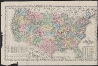
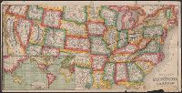
"Entered according to Act of Congress in the year 186[4?] by Charles Desilver in the clerks office of the D, Also shows proposed western railroad routes., Copy 1: Sheet measures 47 x 70 cm., Prime meridians Washington and Greenwich., and Relief shown by hachures.
Publisher:
Charles Desilver,
Subject (Geographic):
United States--Maps
Subject (Name):
Desilver, Charles, Hazzard, J. L, and Yeager, E. (Edward)
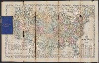
"Entered according to Act of Congress in the year 186[4?] by Charles Desilver in the clerks office of the District Court of the Eastern District of Pe, Includes note and population tables., Prime meridians Washington and Greenwich., and Relief shown by hachures.
Publisher:
Charles Desilver,
Subject (Geographic):
United States--Maps
Subject (Name):
Desilver, Charles, Hazzard, J. L, and Yeager, E. (Edward)
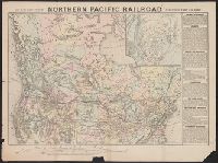
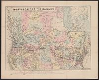
Map of the Northern Pacific Railroad, showing the intercontinental routes, oceanic currents and steamboat lines around the world. and Profiles of the Northern Pacific and the Central and Union Pacific Railroads, showing the difference in configuration of the
Description:
Date inferred from reference in text to lands " ... now ready for sale (January, 1872) ...." and Includes inset of "Map of the Northern Pacific Railroad, showing the intercontinental routes, oceanic currents and steamboat lines around the world," text, and "P
Map of the Northern Pacific Railroad, showing the intercontinental routes, oceanic currents and steamboat lines around the world. and Profiles of the Northern Pacific and the Central and Union Pacific Railroads, showing the difference in configuration of the
Description:
Includes inset of "Map of the Northern Pacific Railroad, showing the intercontinental routes, oceanic currents and steamboat lines around the world," text, and "Profiles of the Northern Pacific and the Central and Union Pacific Railroads, showing the diff
Publisher:
National Railway Publication Company, [187-?].
Subject (Name):
Northern Pacific Railroad Company--Maps
Subject (Topic):
Railroads--Canada--Maps and Railroads--United States--Maps
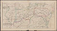
Colored in outline., Covers area from Jefferson City, Mo., to New Haven, Conn., and from Oswego, N.Y., to Blakely, N.C., and In lower left margin: Entered according to Act of Congress, in the year 1851, by Charles Ellet Jr. in the Clerk's Office of the District
General map of the Pennsylvania Railroad and its connections.
Description:
Inset: Round the World , Across the American Continent, via the Pennsylvania Railroad. and Text and tables on verso: Pennsylvania Railroad Great Trunk Line and U.S. Mail Route, July, 1880.