Colton, G. Woolworth (George Woolworth), 1827-1901
Published / Created:
1853
Call Number:
771 1853
Container / Volume:
BRBL_00479
Image Count:
1
Resource Type:
Maps, Atlases & Globes
Alternative Title:
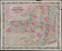
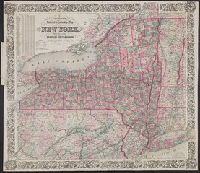
Railroad & township map of the state of New York with parts of the adjoining states & Canada and Railroad and township map of the state of New York with parts of the adjoining states and Canada
Description:
"Entered according to Act of Congress in the Year 1852, by J.H. Colton in the Clerk's Office of the Dist. Court for the Southern Dist. of New York.", Hand colored., Includes inset population table., Map within decorative border., and Prime meridians: Greenwich an
Publisher:
J.H. Colton,
Subject (Geographic):
New York (State)--Administrative and political divisions--Maps. and New York (State)--Maps.
Subject (Name):
Atwood, John M., approximately 1818- and Colton, J. H. (Joseph Hutchins), 1800-1893
Colton, G. Woolworth (George Woolworth), 1827-1901
Published / Created:
1853
Call Number:
771 1853
Container / Volume:
BRBL_00479
Image Count:
1
Resource Type:
Maps, Atlases & Globes
Alternative Title:
Railroad & township map of the state of New York with parts of the adjoining states & Canada and Railroad and township map of the state of New York with parts of the adjoining states and Canada
Description:
"Entered according to Act of Congress in the Year 1852, by J.H. Colton in the Clerk's Office of the Dist. Court for the Southern Dist. of New York.", Hand colored., Includes inset population table., Map within decorative border., and Prime meridians: Greenwich an
Publisher:
J.H. Colton,
Subject (Geographic):
New York (State)--Administrative and political divisions--Maps. and New York (State)--Maps.
Subject (Name):
Atwood, John M., approximately 1818- and Colton, J. H. (Joseph Hutchins), 1800-1893
Colton, G. Woolworth (George Woolworth), 1827-1901
Call Number:
771 1868
Container / Volume:
BRBL_00479
Image Count:
1
Resource Type:
Maps, Atlases & Globes
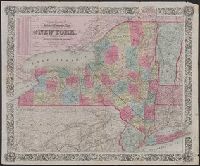
Alternative Title:
Colton's railroad and township map of the state of New York, Railroad & township map of the state of New York with parts of the adjoining states & Canada, and Railroad and township map of the state of New York with parts of the adjoining states and Canada
Description:
"Entered according to Act of Congress in the year 1852, by J.H. Colton, in the clerks office of the dist. court for the southern dist. of N. York.", Includes inset population table., Map within decorative border., Prime meridians: Greenwich and Washington., and R
Publisher:
G.W. & C.B. Colton & Co.,
Subject (Geographic):
New York (State)--Administrative and political divisions--Maps. and New York (State)--Maps.
Subject (Name):
Atwood, John M., approximately 1818- and G.W. & C.B. Colton & Co.
Colton, G. Woolworth (George Woolworth), 1827-1901
Call Number:
771 1867
Container / Volume:
BRBL_00479
Image Count:
1
Resource Type:
Maps, Atlases & Globes
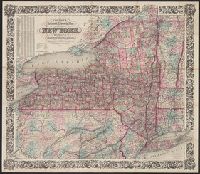
Alternative Title:
Colton's railroad and township map of the state of New York, Railroad & township map of the state of New York with parts of the adjoining states & Canada, and Railroad and township map of the state of New York with parts of the adjoining states and Canada
Description:
"Entered according to Act of Congress in the year 1852, by J.H. Colton, in the clerks office of the dist. court for the southern dist. of N. York.", Includes inset population table., Map within decorative border., Prime meridians: Greenwich and Washington., and R
Publisher:
G.W. & C.B. Colton & Co.,
Subject (Geographic):
New York (State)--Maps.
Subject (Name):
Atwood, John M., approximately 1818- and G.W. & C.B. Colton & Co.
Colton, G. Woolworth (George Woolworth), 1827-1901
Published / Created:
1862
Call Number:
754gme 1860A
Container / Volume:
BRBL_00420
Image Count:
1
Resource Type:
Maps, Atlases & Globes
Alternative Title:
Colton's county and township railroad map of Wisconsin, Illinois, Missouri, & Iowa, County and township rail road map of Wisconsin, Illinois, Missouri, & Iowa, and Wisconsin, Illinois, Missouri, & Iowa
Description:
"Entered according to Act of Congress by Thayer & Colton in the Clerk's office of the District Court of the United States for the Southern District of New York in t and Does not include northern half of Wisconsin; Appleton is the northernmost town on the map.
Publisher:
Drawn, engraved & published by G. Woolworth Colton; and Rufus Blanchard,
Subject (Geographic):
Illinois--Maps, Iowa--Maps, Missouri--Maps, and Wisconsin--Maps
Subject (Name):
Blanchard, Rufus, 1821-1904
Subject (Topic):
Railroads--Illinois--Maps, Railroads--Iowa--Maps, Railroads--Missouri--Maps, and Railroads--Wisconsin--Maps
Colton, G. Woolworth (George Woolworth), 1827-1901
Call Number:
771 1869C
Container / Volume:
BRBL_00479
Image Count:
1
Resource Type:
Maps, Atlases & Globes
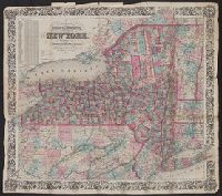
Alternative Title:
Colton's railroad and township map of the state of New York, Railroad & township map of the state of New York with parts of the adjoining states & Canada, and Railroad and township map of the state of New York with parts of the adjoining states and Canada
Description:
"Entered according to Act of Congress in the year 1852, by J.H. Colton, in the clerks office of the dist. court for the southern dist. of N. York.", Includes inset population table., Map within decorative border., Prime meridians: Greenwich and Washington., and R
Publisher:
Published by G.W. & C.B. Colton & Co., 172 William St.,
Subject (Geographic):
New York (State)--Maps.
Subject (Name):
Atwood, John M., approximately 1818- and G.W. & C.B. Colton & Co.
Colton, G. Woolworth (George Woolworth), 1827-1901
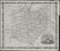
Published / Created:
1852
Call Number:
804 1852
Container / Volume:
BRBL_00543
Image Count:
1
Resource Type:
Maps, Atlases & Globes
Description:
From: Report on the preliminary surveys made for the Cincinnati, Hillsborough and Parkersburg Railway. Cincinnati : Cincinnati Gazette Co. Print., 1852., Includes view of the "State capitol at Columbus.", Prime meridians: Greenwich and Washington., and Shows rai
Publisher:
J.H. Colton,
Subject (Geographic):
Ohio--Maps
Subject (Name):
Atwood, John M., b. ca. 1818, Cincinnati, Hillsborough and Parkersburg Railroad--Maps, and Colton, J. H. (Joseph Hutchins), 1800-1893
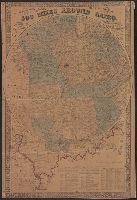
Colton, G. Woolworth (George Woolworth), 1827-1901
Published / Created:
1861
Call Number:
754 1861A
Container / Volume:
BRBL_00416
Image Count:
1
Resource Type:
Maps, Atlases & Globes
Alternative Title:
500 miles around Cairo and G. Woolworth Colton's map of the country five hundred miles around Cairo
Description:
General map centered on Cairo, Ill., with five concentric circles at intervals of 100 miles., Includes a list of the "Principle Forts and Military Stations the Western and Gulf states"., and Insets: [Map of Illinois, Missouri, Arkansas Kentucky, Tennessee, Miss
Publisher:
G. Woolworth Colton,
Subject (Geographic):
Illinois--Maps and United States--History--Civil War, 1861-1865--Maps
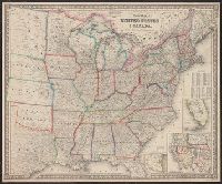
Colton, G. Woolworth (George Woolworth), 1827-1901
Published / Created:
1862, c1861.
Call Number:
75 1862C
Container / Volume:
BRBL_00403
Image Count:
1
Resource Type:
Maps, Atlases & Globes
Alternative Title:
Guide map of the United States & Canada. and New Guide map of the United States & Canada.
Description:
Insets: Plan of the southern portion of Florida.--Western portion of the United States., Prime meridians: Greenwich, Washington., Relief shown by hachures., and Table: Population of the United States.
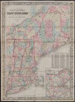
Colton, G. Woolworth (George Woolworth), 1827-1901
Published / Created:
1866, c1860.
Call Number:
753 1866C
Container / Volume:
BRBL_00415
Image Count:
1
Resource Type:
Maps, Atlases & Globes
Alternative Title:
Railroad, township & distance map of New England and Railroad, township and distance map of New England
Description:
Area includes all of New England and parts of New York State, Quebec and New Brunswick., Entered according to act of Congress, in the year 1860, by G. Woolworth Colton in the clerk's office of the District Court of the Southern District of New York., and Relief
Publisher:
G.W. and C.B. Colton & Co.,
Subject (Geographic):
Massachusetts--Maps and New England--Maps
Subject (Name):
G.W. & C.B. Colton & Co
Subject (Topic):
Railroads--Massachusetts--Maps and Railroads--New England--Maps