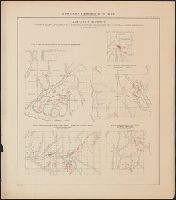
Atlas accompanying volumes I & IV, Geological survey of Wisconsin., Atlas accompanying volumes I and IV, Geological survey of Wisconsin., Geology of Wisconsin, survey of 1873-1879., and Wisconsin geological survey.
Description:
Cover title: Atlas accompanying volumes I & IV, Geological survey of Wisconsin., Includes index., Reissue of selected plates originally published as Atlas of the geological survey of Wisconsin, which accompanied Geology of Wisconsin, survey of 1873-1879., and Running title: Wisconsin geological survey.
Publisher:
Milwaukee Litho. & Engr. Co.,
Subject (Geographic):
Wisconsin--Maps
Subject (Name):
Chamberlin, Thomas C. (Thomas Chrowder), 1843-1928, Irving, R. D, and Strong, Moses McCure
Atlas accompanying geological survey of Wisconsin. and Geology of Wisconsin. Survey of 1873-1879.
Description:
Accompanies: Geology of Wisconsin. Survey of 1873-1879. 4 v. ; 27 cm., Cover title: Atlas accompanying ... geological survey of Wisconsin., Imperfect: library has only plates 3, 4, 5, 6, and 7 (Moses Strong) and plates 3 and 9 (T.C., and Includes cross-sections.
Publisher:
Wisconsin Geological Survey,
Subject (Geographic):
Wisconsin--Maps
Subject (Name):
Chamberlin, Thomas C. (Thomas Chrowder), 1843-1928, Irving, Roland Duer, 1847-1888, Milwaukee Lith. & Engr. Co, and Strong, Moses, 1846-1877
Subject (Topic):
Geology--Wisconsin--Maps and Mines and mineral resources--Wisconsin--Maps
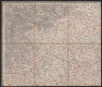
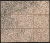
Copy 2: Imperfect: disbound; all sheets but Belluno, Trient, Padua, and Verona wanting; trimmed along neat line, with loss of marginal data. Sheets dissected and mounted on cloth. Stamps on verso: K.K. Un and Relief shown by hachures and spot heights.
Publisher:
Im Verlage der Herder'schen Kunst und Buchhandlung,
Copy 1: Imperfect: disbound; all sheets but Padua, Verona, and Milano wanting; trimmed along neat line, with loss of marginal data. Sheets dissected and mounted on cloth. and Relief shown by hachures and spot heights.
Publisher:
Im Verlage der Herder'schen Kunst und Buchhandlung,
Sanborn fire insurance maps are a rich source of historic data on the urban built environment of North America during the 19th and early 20th centuries. The atlases were created for the purpose of underwriting fire insurance policies, which depended upon accurate and frequently-updated information about construction materials, municipal and transportation infrastructure, industrial and commercial landuse and more. The Yale University Library Map Department scanned its holdings of Sanborn fire insurance maps (consisting primarily of Connecticut towns) in order to make the maps more accessible.
Alternative Title:
Baltic, Connecticut and May 1911, Baltic, Conn.
Description:
"3738, 3 sheets.", Contains information on population, prevailing winds, water facilities and fire department., Includes index of specials., Partial cadastral map., and SMLMAPL 766 B217 1911: Imperfect: sheet slightly chipped and torn, with no loss of text. Sheets disbound.
Subject (Geographic):
Sprague (Conn. : Town)--Maps
Subject (Topic):
Fire risk assessment--Connecticut--Sprague (Town)--Maps and Real property--Connecticut--Sprague (Town)--Maps
Sanborn fire insurance maps are a rich source of historic data on the urban built environment of North America during the 19th and early 20th centuries. The atlases were created for the purpose of underwriting fire insurance policies, which depended upon accurate and frequently-updated information about construction materials, municipal and transportation infrastructure, industrial and commercial landuse and more. The Yale University Library Map Department scanned its holdings of Sanborn fire insurance maps (consisting primarily of Connecticut towns) in order to make the maps more accessible.
Alternative Title:
Baltic, Conn., Jan. 1932 and Baltic, Connecticut
Description:
"(1530).", "(5 sheets).", Contains information on population, prevailing winds, water facilities and fire department., Includes index of streets and specials., Partial cadastral map., and SMLMAPL 766 B217 1932: Imperfect: sheet 1 slightly chipped, with no loss of text. Sheets disbound.
Subject (Geographic):
Sprague (Conn. : Town)--Maps
Subject (Topic):
Fire risk assessment--Connecticut--Sprague (Town)--Maps and Real property--Connecticut--Sprague (Town)--Maps
Ferro meridian., From Bleau's Atlas major (German ed.). Zu Amsterdam : Bey Johannem Blaeu, [ca. 1670]., No. 58 of 69 maps bound together in composite atlas., Relief shown pictorially., and Scale [ca. 1:4 000 000].
[Atlas factice of 42 maps, produced by the Homann Erben firm]
Image Count:
1
Resource Type:
Maps, Atlases & Globes
Alternative Title:
Belgium Catholicum seu decem provinciae Germaniae inferioris and Carte des Pais Bas catholiques ou des X provinces de l’Allegmagne inferieure, etc. dessinee au juste selon les exactes observations astronomiques et operations geometriques des Messur. Cassini, Snellius, Muschenbrok, etc. dressee par Sr. Tobias Maier, mathematicien; aux depens des Heritiers de Homann
Publisher:
Edentibus Homannianis heredib
Subject (Geographic):
Belgium --Maps --Early works to 1800 and Luxembourg --Maps --Early works to 1800
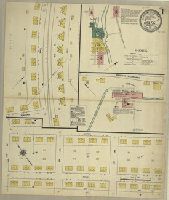
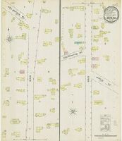
Sanborn fire insurance maps are a rich source of historic data on the urban built environment of North America during the 19th and early 20th centuries. The atlases were created for the purpose of underwriting fire insurance policies, which depended upon accurate and frequently-updated information about construction materials, municipal and transportation infrastructure, industrial and commercial landuse and more. The Yale University Library Map Department scanned its holdings of Sanborn fire insurance maps (consisting primarily of Connecticut towns) in order to make the maps more accessible.
Alternative Title:
Nov. 1887, Berlin, Conn.
Description:
"2 sheets.", Contains information on population, prevailing winds, water facilities and fire department., Partial cadastral map., and SMLMAPL 766 B45 1887: Sheets disbound. "Triplicate" stamp on all sheets.
Subject (Geographic):
Berlin (Conn.)--Maps
Subject (Topic):
Fire risk assessment--Connecticut--Berlin--Maps and Real property--Connecticut--Berlin--Maps
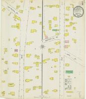
Sanborn fire insurance maps are a rich source of historic data on the urban built environment of North America during the 19th and early 20th centuries. The atlases were created for the purpose of underwriting fire insurance policies, which depended upon accurate and frequently-updated information about construction materials, municipal and transportation infrastructure, industrial and commercial landuse and more. The Yale University Library Map Department scanned its holdings of Sanborn fire insurance maps (consisting primarily of Connecticut towns) in order to make the maps more accessible.
Alternative Title:
Aug. 1895, Berlin, Conn. and Berlin, Conn.
Description:
"3 sheets, 8118.", Contains information on population, prevailing winds, water facilities and fire department., Partial cadastral map., and SMLMAPL 766 B45 1895: Sheets disbound. "Triplicate" stamp on all sheets. Library of Congress copyright stamp on title sheet.
Subject (Geographic):
Berlin (Conn.)--Maps
Subject (Name):
Library of Congress Stamp
Subject (Topic):
Fire risk assessment--Connecticut--Berlin--Maps and Real property--Connecticut--Berlin--Maps