Skip to search
Skip to main content
Skip to first result
Search
You Searched For
Genre
Maps
Publication Place
Washington :
New Search
Search Results
Creator:
Published / Created:
1941
Call Number:
80 1941
Container / Volume:
BRBL_00536
Image Count:
1
Resource Type:
Maps, Atlases & Globes
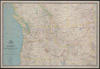
Description:
"Culture by Apphia E. Holdstock. Research by Wellman Chamberlin. Physiography by John J. Brehm.", Issued with the National geographic magazine, v. 79, no. 6, June 1941., Relief shown by hachures and spot heights., and Shows routes of exploration and includes notes on historical sites and points of interest.
Publisher:
The Society,
Subject (Geographic):
Alberta--Maps, British Columbia--Maps, Northwest, Pacific--Maps, and Saskatchewan--Maps
Subject (Name):
Brehm, J. J, Chamberlin, Wellman, Darley, James M. (James Morrison), and Holdstock, A. E
Found in:
Beinecke Rare Book and Manuscript Library > A map of Northwestern United States and neighboring Canadian Provinces / prepared in the Cartographic Section of the National Geographic Society for the National geographic magazine ; James M. Darley, chief cartographer.
Creator:
Published / Created:
[1910]
Call Number:
844fcm Y83 1910
Container / Volume:
BRBL_00615
Image Count:
1
Resource Type:
Maps, Atlases & Globes
Description:
Relief shown by contours and spot heights. and Shows park limits established by various Acts of Congress.
Publisher:
Geological Survey,
Subject (Geographic):
Yosemite National Park (Calif.)--Administrative and political divisions--Maps and Yosemite National Park (Calif.)--Maps
Found in:
Beinecke Rare Book and Manuscript Library > Administrative map of Yosemite National Park, California / topography by R.E. Marshall and A.H. Sylvester ; surveyed in 1893-94, 1896, 1898-99 and 1905.
Creator:
Published / Created:
1943
Call Number:
60gm 1943
Container / Volume:
BRBL_00330
Image Count:
1
Resource Type:
Maps, Atlases & Globes
Alternative Title:
Geographical Section, General Staff ; no. 4209 and GSGS (Series) ; 4209.
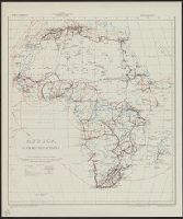
Description:
"Published by the War Office, 1941." and Shows three gauges of railroads, roads, tracks and telegraph cables.
Publisher:
Army Map Service, U.S. Army,
Subject (Topic):
Transportation--Africa--Maps
Found in:
Beinecke Rare Book and Manuscript Library > Africa : communications.
Creator:
Published / Created:
1943
Call Number:
3897 Aj12 1943
Container / Volume:
BRBL_00184
Image Count:
1
Resource Type:
Maps, Atlases & Globes
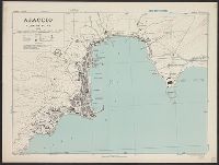
Alternative Title:
[G.S.G.S.] ; 4381 and Great Britain. War Office. General Staff. Geographical Section. G.S.G.S. ; 4381.
Description:
"Contours at 10 metres interval.", Important streets and buildings are named., In upper margin: Corsica 1:5,000 ..., and Military grid.
Publisher:
Army Map Service, U.S. Army,
Subject (Geographic):
Ajaccio (France)--Maps
Found in:
Beinecke Rare Book and Manuscript Library > Ajaccio, plan of port [cartographic material] / Drawn by War Office, 1943.
Creator:
Published / Created:
1983
Call Number:
848 1983
Container / Volume:
BRBL_00631
Image Count:
2
Resource Type:
Maps, Atlases & Globes
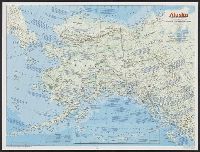
Alternative Title:
The making of America: Alaska.
Description:
"Supplement to the National Geographic, January 1984, page 50A, vol. 165, no. 1.", Inset: Continuation of the Aleutian Islands on same scale as main map., Relief shown by shading and spot heights., Text, maps, ill. on verso., and Title when folded: The making of America: Alaska.
Publisher:
National Geographic Society,
Subject (Geographic):
Alaska--Maps
Found in:
Beinecke Rare Book and Manuscript Library > Alaska / produced by the Cartographic Division, National Geographic Society.
Creator:
Published / Created:
1944
Call Number:
475gmb 1944
Container / Volume:
BRBL_00262
Image Count:
2
Resource Type:
Maps, Atlases & Globes
Alternative Title:
Perpignan S.W.
Description:
On the map of Perpignan, the word "cancelled" is stamped repeatedly in purple ink.
Publisher:
Map Reproduction Sec. R.E.,
Subject (Geographic):
Albania--Maps
Subject (Name):
Great Britain. War Office. General Staff. Geographical Section
Found in:
Beinecke Rare Book and Manuscript Library > Albania, Road information, AF 5811.
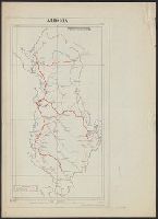
Creator:
Published / Created:
1943
Call Number:
3969gm 1943
Container / Volume:
BRBL_00194
Image Count:
1
Resource Type:
Maps, Atlases & Globes
Alternative Title:
Its A.M.S. ; 6201 and Series (Standard map series designation system) ; 6201.
Description:
"Polyconic projection.", Elevations are shown by hachures and spot heights in meters., and Principal roads and railroads are shown.
Publisher:
Army Map Service,
Subject (Geographic):
Balearic Islands (Spain)--Maps
Subject (Topic):
Transportation--Spain--Balearic Islands--Maps
Found in:
Beinecke Rare Book and Manuscript Library > Balearic islands [cartographic material] : special strategic map / compiled by the Army Map Service.
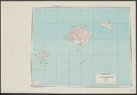
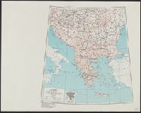
Creator:
Published / Created:
1943
Call Number:
44gm 1943
Container / Volume:
BRBL_00257
Image Count:
1
Resource Type:
Maps, Atlases & Globes
Alternative Title:
Its A.M.S. ; 6201 and Series (Standard map series designation system) ; 6201.
Description:
"Lambert conformal conic projection.", Elevations are shown by hachures and spot heights in meters., Inset shows area with detailed transportation information., and Two classes of roads and five classes of railroads are shown.
Publisher:
Army Map Service,
Subject (Geographic):
Balkan Peninsula--Maps
Subject (Topic):
Transportation--Balkan Peninsula--Maps
Found in:
Beinecke Rare Book and Manuscript Library > Balkans [cartographic material] : special strategic map compiled by the Army Map Service.
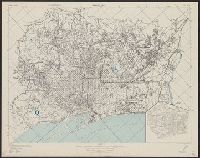
Creator:
Published / Created:
1943
Call Number:
39 B23 1943
Container / Volume:
BRBL_00189
Image Count:
1
Resource Type:
Maps, Atlases & Globes
Alternative Title:
[Series] M981.
Description:
"Copied from a Spanish map, 1:14,000, Plano de Barcelona.", At head of title: Spain 1:14,000., Includes inset., Military grid., and Standard map series designation: M981.
Publisher:
Army Map Service, U.S. Army,
Subject (Geographic):
Barcelona (Spain)--Maps
Found in:
Beinecke Rare Book and Manuscript Library > Barcelona [cartographic material] : city plan.
Branch:v1.61.6 ,Deployed:2024-06-12T09:55:31-04:00