Busch, Georg Paul, d. 1756, engraver Cóvens et Mortier, printer Gundling, Jacob Paul, Freiherr von, 1673-1731 L'Isle, Guillaume de, 1675-1726. Atlas nouveau
Published / Created:
[1742]
Call Number:
1977 Folio 177
Image Count:
2
Resource Type:
Maps, Atlases & Globes
Alternative Title:
Nova Electoratus Brandenburgici tabula edita per I.P. Fr. von Gundling
Description:
"G.P. Busch sculpsit"., From Guillaume de L'Isle's Atlas nouveau., Includes illustrated cartouches., Prime meridian: Ferro., Relief shown pictorially., Shows settlements, universities, roads, forests, rivers, etc., and Title in ms. on verso. Stamp on verso: 305. Sheet measures 54.2 x 67.5 cm. No. 28 of 34 maps bound together.
Publisher:
Bey Johannes Covens und Cornelius Mortier,
Subject (Geographic):
Brandenburg (Germany)--Maps--Early works to 1800 and Poland--Maps--Early works to 1800
From the Collection: Hanbury-Williams, Charles, 1708-1759
Published / Created:
1745 April 23–1749 July 14
Call Number:
LWL MSS 7
Container / Volume:
box 1
Image Count:
270
Description:
The volume holds 266 pages of letters primarily from Philip Dormer Stanhope, Earl of Chesterfield, and Thomas Pelham-Holles, Duke of Newcastle, writing from Whitehall in London. Also present are letters of instruction from George II appointing Hanbury-Williams Envoy Extraordinary at the Court of the King of Poland in 1747 (pages 13-24), his letter of revocation in 1749 for reassignment to the Court of the King of Prussia (pages 199-202), and his instructions from King George II for travel to Anspach to invest Charles William Frederick, the Margrave of Anspach, with the Ensigns of the Order of the Garter (pages 263-265). The letters in the volume were bound nearly in chronological order.
Other items in the volume are a copy of a letter written in 1715 to George Townshend from members of the Board of Trade (pages 1-8) and a copy of Lord Harrington's letter to all ministers abroad regarding court couriers, with a list of charges for their trips between Whitehall or Hanover and foreign cities (pages 9-12). Near the end of the volume (pages 243-262), is a "Paper delivered by Count Fleming," in which Saxon minister Karl Georg Friedrich Flemming mentions the June 1747 "double wedding" of Bavarian Elector Maximilian Joseph and his sister Princess Maria Antonia to the Electoral Prince Friedrich Christian of Saxony and his sister Princess Maria Anna; the marriage united the ruling families of Bavaria and Saxony.
The volume is untitled; it is in a stiff-board binding covered in brown paper with a blue linen spine and has no label on the front cover. The Hanbury-Williams volume number is 34; the Phillipps number is 10906.
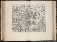
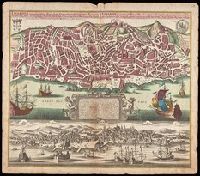
Lisabon die prächtigste Königl. Residenz Statt in Portugall u. florisanteste Handels Plaz am Austfluss des Tagi
Description:
"Cum gratia et privil. S.R.I. Vicariatus in partibus Rheni, Suevice, et Juris Franconici.", Historiated cartouche with note., Includes aerial view of "Lisabon" at bottom., and Manuscript number in upper right corner. From the Karpinski-von Wieser Map Collection.
Publisher:
[Matthaeus Seutter]
Subject (Geographic):
Lisbon (Portugal)--Aerial views--Early works to 1800, Lisbon (Portugal)--Maps--Early works to 1800, and Portugal--Lisbon
Guessefeld, F. L. (Franz Ludwig), 1744-1807 Homann Erben (Firm)
Published / Created:
1775
Call Number:
1983 Folio 23
Collection Title:
[Atlas factice of 50 maps, primarily by Johann Baptist Homann and/or issued by the Homann Erben
Image Count:
1
Publisher:
Impensis Homannianorum Haeredum
Subject (Geographic):
Bohemia (Czech Republic) --Maps --Early works to 1800, Galicia (Poland and Ukraine) --Maps --Early works to 1800, and Ukraine --Maps --Early works to 1800
Mappa Aestivarvm insularum, alias Barmvdas dictarum
Description:
Below map, list of proprietors in 12 columns flanked by coats-of-arms., Borders are hand colored., and Not hand colored. With watermark. Sheet measures 46 x 55 cm.
Charte worauf in einem Begriff und Anblick alle natürliche politische und Kunst-termini oder Wörter benen̄et.
Description:
1an, Demonstrates cartographic terms, symbols, depictions of landforms, etc., Has watermark., Relief shown pictorially., and Title in upper margin: Charte worauf in einem Begriff und Anblick alle natürliche politische und Kunst-termini oder Wörter benen̄et ...
Publisher:
Matthaeo Seutter,
Subject (Topic):
Cartography--Germany, Cartography--Methodology--Maps, Imaginary places--Maps--Early works to 1800, Maps--Symbols, and Maps--Terminology