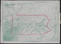
Shows coal and oil regions from Lake Ontario through much of West Virginia; most of New York State is shown, though without geological detail. Also shows locations of steel works, foundries, etc.
Publisher:
Jacob Haehnlen [lithographer],
Subject (Geographic):
Pennsylvania--Maps
Subject (Topic):
Canals--Pennsylvania--Maps, Coal--Pennsylvania--Maps, Iron industry and trade--Pennsylvania--Maps, and Railroads--Pennsylvania--Maps
"To accompany Report of Rear Admiral C. H. Davis, U.S.N., ordered by Resolution of the Senate of the United States of March 19, 1866., From: Charles H. Davis' Report on interoceanic canals and railroads between Atlantic, and North oriented to left side of map.
Publisher:
Bowen & Co.,
Subject (Geographic):
Honduras--Maps
Subject (Name):
Bowen & Co, Davis, Charles Henry, 1807-1877, Honduras Interoceanic Railway Company, Jeffers, William N. (William Nicholson), 1824-1883, Squier, E. G. (Ephraim George), 1821-1888, and Trautwine, John C. (J
Cowperthwait, Desilver & Butler Young, J. H. (James Hamilton)
Published / Created:
1854
Call Number:
30 1854
Container / Volume:
BRBL_00032
Image Count:
1
Resource Type:
Maps, Atlases & Globes
Alternative Title:
Europe
Description:
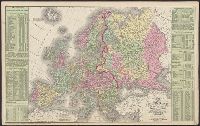
Index., Information provided on the European population., Prime meridians: Greenwich, Washington., Relief shown by hachures., and Scale: "164 miles to an inch or 1/10,400,000 of nature."
Includes illustrations of notable buildings, a list of the faculty of Starling Medical College, a Columbus business directory, statistics of Franklin Co, for 1855. and Insets: Map of the city of Columbus, Ohio -- Grove City, Jackson Tp. -- Hilliard -- North C
Publisher:
R.C. Foote Jr.,
Subject (Geographic):
Columbus (Ohio)--Maps and Franklin County (Ohio)--Maps
Mitchell, S. Augustus (Samuel Augustus), 1792-1868
Published / Created:
1831
Call Number:
76 1831A
Container / Volume:
BRBL_00444
Image Count:
1
Resource Type:
Maps, Atlases & Globes
Alternative Title:
Maine, New Hampshire & Vermont
Description:
"J.H. Young Sc.", Hand col. Sheet measures 43 x 55.5 cm., Includes statistical table and inset of northern Maine., Prime meridian: Washington., and Relief shown by hachures.
Publisher:
S.A. Mitchell,
Subject (Geographic):
Maine--Maps, New Hampshire--Maps, and Vermont--Maps