France 1:5,000, Geographical Section, General Staff ; no. 4234, and GSGS (Series) ; 4234.
Description:
"1-44.", "First G.S.G.S. ed., 1943.", "Grid provisional. Nord de Guerre zone grid.", "War Office 1943.", Important street names, industries and port facilities are shown., Includes index., Major street names, some buildings, and sites in French., and Relief shown by
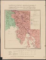
Map of Jugoslav territory and Map of Southern Slav territory
Description:
Imperfect: Cover wanting. Overprint in red on map indicating "Territory occupied by Italy 4000 S.q Mi.". Red stamp in upper right corner of sheet: "American Embassy. Paris, France Dec. 13, 1918"., Legend in English, Croatian, and French., and Sh
Publisher:
Christophers,
Subject (Geographic):
Yugoslavia--Maps and Yugoslavia--Maps--1915
Subject (Topic):
Ethnology--Yugoslavia--Maps and World War, 1914-1918--Maps
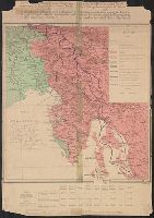
Italian revendications against Austria, which fought for Pangermanism against the Entente, and the Italian revendications against the Jugoslavs, who are the bulwark against the Pangermanism and therefore the natural allies of the Entente
Description:
Date from French catalog record., Legend and text in French and English., and Ms. notes on map indicating Treaty of London Line, with corresponding ms. note "This is the correct interpretation of the position of Treaty of London Line. Italians w
Publisher:
Wuhrer,
Subject (Geographic):
Italy--Boundaries--Maps, Italy--Ethnology--Maps, Yugoslavia--Boundaries--Maps, and Yugoslavia--Ethnology--Maps
Subject (Topic):
World War, 1914-1918--Italy--Maps and World War, 1914-1918--Yugoslavia--Maps
Italian revendications against Austria, which fought for Pangermanism against the Entente, and the Italian revendications against the Jugoslavs, who are the bulwark against the Pangermanism and therefore the natural allies of the Entente
Description:
Date from French catalog record., Legend and text in French and English., Ms. notes on map indicating Treaty of London Line, with corresponding ms. note "This is the correct interpretation of the position of Treaty o, and Relief shown by shading.
Publisher:
Wuhrer,
Subject (Geographic):
Italy--Boundaries--Maps, Italy--Ethnology--Maps, Yugoslavia--Boundaries--Maps, and Yugoslavia--Ethnology--Maps
Subject (Topic):
World War, 1914-1918--Italy--Maps and World War, 1914-1918--Yugoslavia--Maps
Carte ethnographique de la Hongrie construite en la accordance avec la densité de la population and Ethnographical map of Hungary based on the density of population
Description:
"Every square millimeter coloured indicates 100 inhabitants. According to the census of 1910.", Imperfect. text and leaf wanting. Copy 2 mounted on linen., In English, Hung, and Includes 1 inset map showing area around Budapest, sclae 1:5,000,000.
Carte ethnographique de la Hongrie construite en la accordance avec la densité de la population and Ethnographical map of Hungary based on the density of population
Description:
"Every square millimeter coloured indicates 100 inhabitants. According to the census of 1910.", Imperfect. text and leaf wanting., In English, Hungarian and French., and Includes 1 inset map showing area around Budapest, sclae 1:5,000,000.
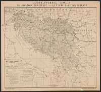
Jugoslav territory, Jugoslovenska zemlja, Map of southern Slav territory, and Territoire Iougoslave
Description:
"Issued for the Jugoslav Committee in London.", "September, 1915, London.", In upper margin: "Jugoslovenska zemlja, the Jugoslav territory, le territoire Iougoslave.", Includes "Jugoslav orthography.", and Legend in English, Croatian, and French.
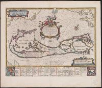
Mappa Aestivarvm insularum, alias Barmvdas dictarum
Description:
Based on Speed's map of 1626 but with new decorations., Below map, list of proprietors in 12 columns with arms of England and Bermuda., From the author's Theatre du monde ou nouvel atlas., Latin and English text on recto and French text on verso., Signature on verso: G., and Title on verso: L'Isle de Barmudas, avec ses voysines.
Publisher:
[Guillaume et Iean Blaeu,
Subject (Geographic):
Bermuda Islands--Maps--Early works to 1800
Subject (Name):
Blaeu, Joan, 1596-1673. Theatrum orbis terrarum. French and Blaeu, Willem Janszoon, 1571-1638. Theatrum orbis terrarum. French
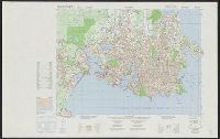
Canada. Mapping and Charting Establishment. MCE ; 317., Carte militaire de la ville. Victoria [map], Series A902 [map], and Victoria [map]
Description:
"Information depicted current as of 1976. Printed 1979.", "Transverse Mercator projection.", and Includes glossary, grid reference diagr., administrative boundary diagr., and diagr. showing "Relationship of the military city map to the national topographic syst
Publisher:
The Establishment : [available from] Canada Map Office, Dept. of Energy, Mines, and Resources,