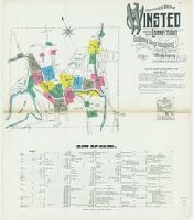
Sanborn fire insurance maps are a rich source of historic data on the urban built environment of North America during the 19th and early 20th centuries. The atlases were created for the purpose of underwriting fire insurance policies, which depended upon accurate and frequently-updated information about construction materials, municipal and transportation infrastructure, industrial and commercial landuse and more. The Yale University Library Map Department scanned its holdings of Sanborn fire insurance maps (consisting primarily of Connecticut towns) in order to make the maps more accessible.
Alternative Title:
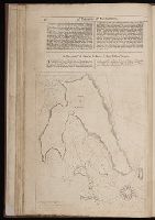
May 1909, Winsted, Conn. and Winsted, Litchfield County, Connecticut
Description:
"18 sheets 1400.", Contains information on population, prevailing winds, water facilities and fire department., Includes index of streets and specials., Partial cadastral map., and SMLMAPL 766 W73 1909: Sheets disbound. "Triplicate" stamp on sheets. Library of Congress copyright stamp on title sheet.
Subject (Geographic):
Winsted (Conn.)--Maps
Subject (Name):
Library of Congress Stamp
Subject (Topic):
Fire risk assessment--Connecticut--Winsted--Maps and Real property--Connecticut--Winsted--Maps
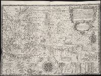
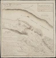
The West-India pilot: containing piloting directions for Port Royal and Kingston harbours in
Image Count:
1
Subject (Geographic):
Atlantic Ocean --Maps --Early works to 1800, Central America --Maps --Early works to 1800, Providence Island (Colombia) --Maps, and Santa Catalina Island (Colombia)
Subject (Topic):
Harbors --Atlantic Coast (North America) --Maps --Early works to 1800, Nautical charts --Atlantic Coast (North America) --Early works to 1800, Nautical charts --Caribbean Area --Early works to 1800, Nautical charts --West Indies --Early works to 1800, Pilot guides --Atlantic Coast (North America) --Early works to 1800, Pilot guides --Caribbean Area --Early works to 1800, and Pilot guides --West Indies --Early works to 1800
Collection Created:
London : Printed for the author and sold by S. Hooper ..., MDCCLXXI [1771]
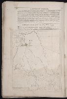
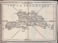
Summario de la generale historia de l’Indie Occidentali. Part 1
Image Count:
1
Description:
Facing p. 79.
Subject (Geographic):
America --Discovery and exploration --Spanish --History --16th century, America --Early works to 1600, Dominican Republic --Maps, Haiti --Maps --Early works to 1800, and Hispaniola --Maps --Early works to 1800
Subject (Name):
Hardy-Mennil, binder, Nicolini da Sabbio, Stefano, printer, and Ramusio, Giovanni Battista, 1485-1557, ed
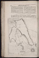
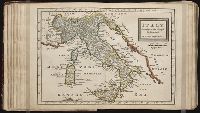
Twenty four new and accurate maps of the several parts of Europe ... : all (except the last) new
Image Count:
1
Alternative Title:
Italy in general, with Naples, the Isle of Sicily, &c
Description:
In pencil on verso: 19.
Subject (Geographic):
Italy --Maps --Early works to 1800, Naples (Italy) --Maps --Early works to 1800, and Sicily (Italy) --Maps --Early works to 1800
Subject (Name):
Barker, B. (Benjamin), d. 1764, bookseller, Clements, Henry, d. 1719, bookseller, King, Charles, d. 1735, bookseller, Nicholson, John, d. ca. 1717, bookseller, Parker, Richard, fl. 1692-1725, bookseller, and Tooke, Benjamin, d. 1716, bookseller
Subject (Topic):
Atlases --Early works to 1800
Collection Created:
[London] : Sold by J. Nicholson at the King’s-Arms in Little Britain, Benj. Barker and Charles King ..., Benj. Tooke ..., Hen. Clements ..., R. Parker and Ralph Smith under the Royal-Exchange ..., [1715?]