
You Searched For
1 - 5 of 5
Search Results
2.
- Creator:
- United States. General Land Office
- Published / Created:
- 1866
- Call Number:
- 825fcm 1866
- Container / Volume:
- BRBL_00575
- Image Count:
- 1
- Resource Type:
- Maps, Atlases & Globes
- Alternative Title:
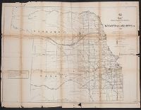
- (12) map showing the progress of the public surveys in Kansas and Nebraska
- Description:
- Also shows coal, salt, lead, platina, and marble deposits., Appears in General Land Office's Maps accompanying the report of the Commissioner of the General Land Office., At head of title: (12)., In upper right margin: N 15., and Relief shown by hachures.
- Publisher:
- s.n.],
- Subject (Geographic):
- Kansas--Maps and Nebraska--Maps
- Subject (Name):
- United States. General Land Office. Maps accompanying report of the commissioner of the General Land Office
- Subject (Topic):
- Public lands--Kansas--Maps and Public lands--Nebraska--Maps
- Found in:
- Beinecke Rare Book and Manuscript Library > Map showing the progress of the public surveys in Kansas and Nebraska / Surveyor General's Office ; Department of the Interior, General Land Office, Oct. 2nd, 1866.
3.
- Creator:
- United States. General Land Office
- Published / Created:
- 1866
- Call Number:
- 825fcm 1866
- Container / Volume:
- BRBL_00575
- Image Count:
- 1
- Resource Type:
- Maps, Atlases & Globes
- Alternative Title:
- (12) map showing the progress of the public surveys in Kansas and Nebraska
- Description:
- Also shows coal, salt, lead, platina, and marble deposits., Appears in General Land Office's Maps accompanying the report of the Commissioner of the General Land Office., At head of title: (12)., In upper right margin: N 15., and Relief shown by hachures.
- Publisher:
- s.n.],
- Subject (Geographic):
- Kansas--Maps and Nebraska--Maps
- Subject (Name):
- United States. General Land Office. Maps accompanying report of the commissioner of the General Land Office
- Subject (Topic):
- Public lands--Kansas--Maps and Public lands--Nebraska--Maps
- Found in:
- Beinecke Rare Book and Manuscript Library > Map showing the progress of the public surveys in Kansas and Nebraska / Surveyor General's Office ; Department of the Interior, General Land Office, Oct. 2nd, 1866.
- Creator:
- United States. General Land Office
- Published / Created:
- 1860?
- Call Number:
- 825fcm 1860
- Container / Volume:
- BRBL_00575
- Image Count:
- 1
- Resource Type:
- Maps, Atlases & Globes
- Alternative Title:
- Senate executive document (United States. Congress. Senate) ; 36th Congress, 2nd session, no. 1.
- Description:
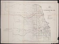
- "Sen. ex. doc. no. 1, 2d sess. 36th Cong." and At head of title: (6).
- Publisher:
- s.n.],
- Subject (Geographic):
- Kansas--Maps and Nebraska--Maps
- Subject (Topic):
- Public lands--Kansas--Maps and Public lands--Nebraska--Maps
- Found in:
- Beinecke Rare Book and Manuscript Library > Map showing the progress of the public surveys in the territories of Kansas and Nebraska : to accompany annual report of the Surveyor General, 1860.
5.
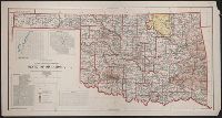
- Creator:
- United States. General Land Office
- Published / Created:
- 1907
- Call Number:
- 827 1907
- Container / Volume:
- BRBL_00577
- Image Count:
- 1
- Resource Type:
- Maps, Atlases & Globes
- Description:
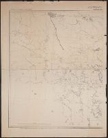
- Includes insets of Guthrie, Muskogee, McAlester, and Lawton., Prime meridians: Washington and Greenwich., Relief shown by shading., and Shows counties and Indian, military, forest, and "public purpose" reserves.
- Publisher:
- General Land Office?],
- Subject (Geographic):
- Oklahoma--Maps
- Subject (Name):
- Berthrong, I. P, Dinsmore, A. F, Helm, Charles J, and Hendges, M
- Found in:
- Beinecke Rare Book and Manuscript Library > State of Oklahoma / compiled from the official records of the General Land Office and other sources under the direction of I.P. Berthrong ; compiled by A.F. Dinsmore and M. Hendges ; drawn by Charles J. Helm.