
- None[remove]6
You Searched For
1 - 6 of 6
Search Results
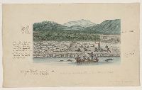
1. Drawings and sketches made during a voyage around the world, 1791-1795
- Creator:
- Bacstrom, Sigismund
- Published / Created:
- 1792-1800, bulk 1792-1794.
- Call Number:
- WA MSS S-2405 (Oversize)
- Image Count:
- 130
- Abstract:
- Views of natives, landscapes, and ethnographic objects of the Northwest Coast of America, Pacific Islands, China, and South America. Half of the drawings are fully rendered watercolors, others are rough sketches with detailed notes on coloring, dates of anchorages, and occasionally events on board ship or shore. Ten watercolors are of Native Americans of the Northwest Coast, eight of them signed by Bacstrom and fully executed after his return. There are ten views of the Northwest Coast of America, including Nootka Sound and Queen Charlotte's Island, and Native American villages at Norfolk Sound and Fitzhugh Sound. There are two maps of Queen Charlotte's Island, six watercolors of canoes from the Northwest Coast and the Pacific Islands, and four drawings of Native American and Pacific island ethnographic objects and There are eighteen watercolor sketches and drawings of the coast of South America and the islands in the Pacific, including Hawaii and Staaten Island near Cape Horn. Other drawings include ten watercolors of Chinese men and women, a pencil drawing of a Chinese junk, and a watercolor of an American tea plant. The drawings are accompanied by a highly finished watercolor of the Greenland Whale Fishery not made during the voyage, and a manuscript catalog of "some accurate and characteristic original drawings" made on the voyage with prices; not all of the drawings listed correspond to drawings present in the collection
- Description:
- Bacstrom, a protégé of Sir Joseph Banks, served as surgeon on a private fur-trading ship which sailed around Cape Horn to the South Seas, Nootka Sound, the East Indies, and the Cape. Bacstrom left the ship at Nootka Sound and later served as surgeon on several ships, visiting China, India, the Cape, and the Americas., Accompanied by a container list., Manuscript captions., and View a digital version in the Beinecke Library's Digital Images Online database
- Subject (Geographic):
- Northwest, Pacific, Hawaii, China, Islands of the Pacific, Queen Charlotte Islands (B.C.), South America, and Greenland
- Subject (Topic):
- Indians of North America, Social life and customs, Clothing and dress, and Whaling
- Found in:
- Beinecke Rare Book and Manuscript Library > Drawings and sketches made during a voyage around the world, 1791-1795

2. England [art original]
- Creator:
- Hughes, J., active 1872, artist
- Published / Created:
- [30 March 1872]
- Call Number:
- Drawings H893 no. 1 Box D128
- Image Count:
- 1
- Resource Type:
- still image
- Abstract:
- A comic map of Great Britain: an old woman is shown in profile, facing to the left, and seated on the back of a dolphin-like monster. At the top her cap is Scotland; her neck is labeled R. Tees (River Tees) and along her back is "Humber" and "The Wash" The mouth of the creature is labeled "Thames". The other points on the map are: Isle of Wight and Bristol Channel, Cardogan Bay, and Anglesea (a bird perched on the woman's out-stretched hand).
- Alternative Title:
- Britannia
- Description:
- Title supplied by artist above design., Added title supplied by cataloger, based on the Gillray print of which this is a copy., Signed and dated by the artist in lower margin., and Drawn after James Gillray's print "Britannia", published 25 June 1791. Cf. No. 8045 in the Catalogue of prints and drawings in the British Museum. Division I, political and personal satires, v. 6.
- Subject (Geographic):
- England
- Found in:
- Lewis Walpole Library > England [art original]
3. Insurance maps of San Francisco, California
- Creator:
- Sanborn Map Company, cartographer
- Published / Created:
- 1881-
- Call Number:
- 1997 Folio 77
- Image Count:
- 47
- Description:
- Bein 1997 Folio 77: v. 1 only. and Includes index.
- Publisher:
- Sanborn Map and Pub. Co.
- Subject (Geographic):
- California, San Francisco, and San Francisco (Calif.)
- Subject (Topic):
- Fire risk assessment
- Found in:
- Beinecke Rare Book and Manuscript Library > Insurance maps of San Francisco, California
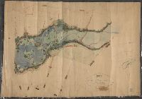
4. Map of a portion of Westville & New Haven
- Creator:
- Mitchell, Donald Grant, 1822-1908, cartographer
- Published / Created:
- Decr. 1863.
- Call Number:
- Roll Map 78
- Image Count:
- 2
- Resource Type:
- cartographic image
- Alternative Title:
- Map of a portion of Westville and New Haven
- Description:
- Imperfect: mutilated. Mounted on linen. Manuscript note on verso (partially trimmed): Map of old P[?]; D.G. Mitchell., Date of production precedes statement of responsibility., Oriented with north towards right., Relief shown by hachures., "Scale: 140 ft. to inch.", Coordinates not present on map and are approximated., Includes names of ownership., and Includes inset map of surrounding area in lower right corner.
- Subject (Geographic):
- New Haven (Conn.)
- Found in:
- Beinecke Rare Book and Manuscript Library > Map of a portion of Westville & New Haven
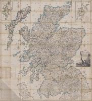
5. Scotland : drawn and engrav'd from a series of angles and astronomical observations
- Creator:
- Ainslie, John (Surveyor)
- Published / Created:
- [1800]
- Call Number:
- Folio 15 800Ai
- Image Count:
- 1
- Resource Type:
- cartographic image
- Alternative Title:
- Scotland drawn and engraved from a series of angles and astronomical observations
- Description:
- Title from cartouche., Engraved throughout., Relief shown by contour lines and pictures., Scale of miles 69 1/2 to a degree., Another imprint: "Published according to Act of Parliament Jan. 1st. 1789 by John Ainslie ... and William Faden ..." at bottom of sheet., Inset maps: "Shetland Islands laid down upon a less scale than the map ... "; "A Map of the Orkney Islands ...", Distance tables and lists of heights of hills and roads from Edinburgh to London., Edinburgh meridian, with note of degrees from Greenwich., Title cartouche shows men fishing and herding cattle, with sheep goats and foliage., Six compass roses., This issue not in Chubb, T. Printed maps in the atlases of Great Britain and Ireland., and Scotland.
- Publisher:
- Printed and sold by the proprietor Thomas Brown, North Bridge Street, Edinburgh and Publish'd according to Act of Parliament with improvements till 1800 by Thomas Brown ... Edinburgh and William Faden ... London
- Subject (Geographic):
- Scotland, Orkney (Scotland), Shetland (Scotland), Scotland., Orkney., and Shetland.
- Subject (Topic):
- Description and travel and Travel
- Found in:
- Lewis Walpole Library > Scotland : drawn and engrav'd from a series of angles and astronomical observations

6. [Manuscript map of Alaska].
- Published / Created:
- [1817?]
- Call Number:
- Small Manuscript 848 1817
- Image Count:
- 2
- Description:
- By Cptn. Charles Randall, R.N. and Verso: "David's lamentation over his son Absolom ... "
- Subject (Geographic):
- Alaska
- Found in:
- Beinecke Rare Book and Manuscript Library > [Manuscript map of Alaska].